Oundle is a market town on the left bank of the River Nene in North Northamptonshire, England, which had a population of 5,735 at the time of the 2011 census. It is 69 miles north of London and 12 mi (19 km) south-west of Peterborough. The town is home to Oundle School.

East Northamptonshire was from 1974 to 2021 a local government district in Northamptonshire, England. Its council was based in Thrapston and Rushden. Other towns include Oundle, Raunds, Irthlingborough and Higham Ferrers. The town of Rushden was by far the largest settlement in the district. The population of the district at the 2011 Census was 86,765.

Corby is a constituency in Northamptonshire represented in the House of Commons of the UK Parliament since May 2015 by Tom Pursglove of the Conservative Party.

Wellingborough is a constituency represented in the House of Commons of the UK Parliament since 2005 by Peter Bone, a Conservative.
Stanwick is a village and civil parish in North Northamptonshire, England.
Thrapston was a rural district in England from 1894 to 1935. It was one of the only rural districts to be split between administrative counties, with part in Northamptonshire and part in Huntingdonshire.
Gretton was a rural district in Northamptonshire, England from 1894 to 1935. It was formed from the Northamptonshire part of the Uppingham rural sanitary district.
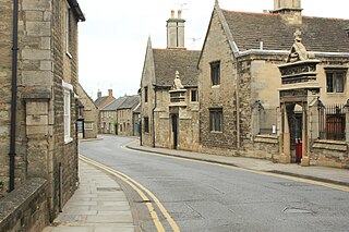
Oundle was a rural district in England from 1894 to 1935.
Kettering was a rural district in Northamptonshire in England from 1894 to 1974.
The Brixworth Rural District was a rural district in Northamptonshire, England from 1894 to 1974. It was named after and administered from the village of Brixworth.
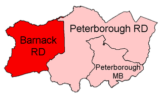
Barnack was a rural district in the Soke of Peterborough and later Huntingdon and Peterborough from 1894 to 1974.

Norman Cross was a rural district in Huntingdonshire from 1894 to 1974.
Easton on the Hill was a rural district in Northamptonshire, England from 1894 to 1935. It was formed under the Local Government Act 1894 from that part of the Stamford rural sanitary district which was in Northamptonshire proper. It consisted of the three parishes of Collyweston, Duddington and Easton on the Hill.
Thrapston Town F.C. is an English football club based in Thrapston, Northamptonshire, and competes in the Northamptonshire Combination Premier Division.
The A605 road is a main road in the English counties of Northamptonshire and Cambridgeshire.

North Northamptonshire is one of two local authority areas in Northamptonshire, England. It is a unitary authority area forming about one half of the ceremonial county of Northamptonshire. It was created in 2021. Its notable towns are Kettering, Corby, Wellingborough, Rushden, Raunds, Desborough, Rothwell, Irthlingborough, Thrapston and Oundle. The council is based at the Corby Cube in Corby.

The Nene Way is a waymarked long-distance footpath in England running through the English counties of Northamptonshire, Cambridgeshire and Lincolnshire. It generally follows the course of the River Nene.

Huntingdon was a rural district in Huntingdonshire from 1894 to 1974, lying to the north and west of urban Huntingdon. It was formed in 1894 under the Local Government Act 1894 from the earlier Huntingdon rural sanitary district.

St Neots was a rural district in Huntingdonshire, England from 1894 to 1974, around the northern and eastern sides of the urban area of St Neots.