
Nsukka is a town and a Local Government Area in Enugu State, Nigeria. Nsukka shares a common border as a town with Edem, Opi, Ede-Oballa, and Obimo.

Armstrong, officially the City of Armstrong is a city in the North Okanagan of the Canadian province of British Columbia, between Vernon and Enderby. It overlooks the Spallumcheen Valley, which forms a broad pass between the Okanagan Valley to the south and the Shuswap Country to the north, and is about 480 km (300 mi) from each of Vancouver, B.C. and Spokane, Washington. The town of Armstrong celebrated its centennial in 2013.

Ashford is a small village situated in the north-west on the Northern Tablelands of the state of New South Wales. The New England rural village of Ashford lies within the broad sunlit lands 748 km north of Sydney, 500 km south west of Brisbane, close to the Queensland border. Ashford is 430 metres above sea level and located 56 km north of Inverell on a major arterial road, connecting the Gwydir and Bruxner highways through to the Queensland border.
Blue Jay is an unincorporated community located in San Bernardino County, California. It is located in the San Bernardino Mountains, above a region of California known as the Inland Empire. It is within the San Bernardino National Forest. Blue Jay Village itself is located one mile from the southwestern bank of Lake Arrowhead.

Enugu State is a state in the South-East geopolitical zone of Nigeria, bordered to the north by the states of Benue and Kogi, Ebonyi State to the east and southeast, Abia State to the south, and Anambra State to the west. The state takes its name from its capital and largest city, Enugu. The city acquired township status in 1917 and was called Enugwu-Ngwo. Due to the rapid expansion towards areas owned by other indigenous communities, it was renamed Enugu in 1928.

Balscaddan is a village in Fingal, Ireland. It is the most northerly village of County Dublin, approx 5 km north of Balbriggan and close to the border with County Meath.

Plympton–Wyoming is a town in the Canadian province of Ontario, located in Lambton County immediately east of Sarnia. It is the seat of the Lambton County Council.
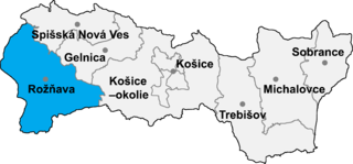
Jovice is a village and municipality in the Rožňava District in the Košice Region of middle-eastern Slovakia.
The Sanjay Education Society's College of Engineering and Polytechnic was founded in 1983. The college is affiliated to the North Maharashtra University, Jalgaon, India, under purview of the AICTE. The surrounding area is mostly arid with some farmland.
Abiriba pronounced [/E`biriba`/] is an ancient Enuda kingdom in Abia State, in southeastern Nigeria, traditionally an Igbo speaking region. It is in the Ohafia local government area.
Awo-Idemili is the headquarters of Orsu Local Government, Imo State in southeastern Nigeria. It is located near the city of Orlu.
Edem, occasionally referred to by the misnomer "Edem Ani" to distinguish it from Edem Nru and Edem Iheakpu Awka, is an ancient traditional state in Nsukka Local Government Area of Enugu State, Nigeria. A culturally rich, stable traditional political system with institutions of government dating back 900 years, it is one of the oldest civilisations in existence pre-colonial Nigeria. Today, it is made up of three autonomous communities/towns, listed in order of seniority: Akpa-Edem, Ozi-Edem and Edem-Ani but unified as a culturally inviolable and indivisible federated entity.
Okpekpe is a town in Etsako East Local Government Area of Edo State, Nigeria. It is located about 25 kilometres (16 mi) northeast of Auchi. It has a population of 3155 inhabitants. Its people belong to a homogeneous group of people, called the Afemai.
Obimo is a town in the Nsukka local government area of Enugu state in Nigeria. Its full name is Obimo Asebere. It is made up of five communities:
Ede-Enu is an autonomous community within the Nsukka Local Government Area (LGA) in Enugu State, Nigeria.
The Waawa clan of Northern Igboland, also referred to as Ndi Waawa, Wawa People, are a unique sub-group of the Igbo people in Enugu and Ebonyi State, Nigeria, consisting of several communities, who all speak a unique dialect of Igbo called Waawa. The most notable among these are the Agbaja and Ngwo which consist of peoples between the wooded lands of Awka to the rocky valleys of Enugu. The Agbaja are made up of communities in present-day Ngwo clan, Udi, Ezeagu, Umulokpa, Igbo-Etiti, Oji River, greater Awgu, Odume, Ndiagbor, Nenwe, Mpu, Okpanku and Enugu East Local Government Areas. Other notable parts of the Waawa clan include Nkanu, Nsukka, Abia, Nike, Agbani, Owo, and other communities in Enugu State. The Waawa are most notably associated with Chief Onyeama's people from Eke, who was the paramount ruler of Agbaja in the early 20th century.
Nru Nsukka is a suburb located in Nsukka town. Nru Nsukka is one of the former old three autonomous communities: Mkpunanor, Nru and Ihe n'Owerre that made up the Nsukka urban area. Nru Nsukka having been upgraded to a suburban area was split into three newer autonomous communities with newly installed traditional rulers. Since 2018, the suburb is now made up of Iheagu Nru autonomous community with its traditional ruler as Sylvanus Arumah, Ezema ne Edem autonomous community with its traditional ruler as Linus.O. Atugwu and the youngest being Umuoyo Nru autonomous community with Paul Atanike as its traditional ruler elect.
Ezema is one of four sub-communities that made up Nru Nsukka town in Nsukka Local Government Area, Nigeria. It is adjacent to the three other sub-communities in Nru Nsukka: Edem Nru, Umuoyo Nru and Iheagu. It also shares common boundaries with Various communities such as Umuoyo, Iheagu, Agbamere/Amike and Umabor both in Eha Alumona.

Neke is a town located in Isi-Uzo Local Government Area of Enugu State in South Eastern Nigeria. Bordered by towns such as Nike, Ikem, Mbu, Eha Amufu, Obollo and UmuAlor, Neke is a small town with a strong backbone. In the pre-colonial era, the people of Neke were known as fearsome warriors who had an economic stronghold on neighboring areas. In the present day, there are 5 main districts located in Neke namely; Ishienu, Akpani, ObeguAba, Umugwu and Umuegwu. These districts represent villages made up of clans and kindred prominent to the town's social structure.

The Idaasha also spelt Idaaca, Idaaṣa and Idaaitsa are a group of the Yoruba people, situated in the central portions of the Collines Department of Benin, West Africa. They are based in and around the communities of Glazoué and Dassa both situated west of the Oueme River. Every year, the Idaasha organize a festival of arts and culture known as FACI to celebrate their culture and heritage, themed Àshà Ìbílẹ̀.
