Eilean na Muice Duibhe

Last updated
Eilean na Muice Duibhe
Duich Moss
Location Islay, Scotland
Nearest city Bowmore
Coordinates 55°43′20″N6°15′20″W / 55.722222°N 6.255556°W / 55.722222; -6.255556 Coordinates: 55°43′20″N6°15′20″W / 55.722222°N 6.255556°W / 55.722222; -6.255556
Area5.76 km2 (2.22 sq mi) [1]
Established1988
Governing body Scottish Natural Heritage (SNH)

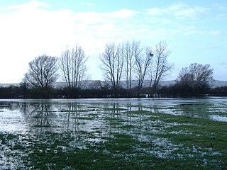
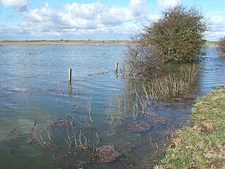
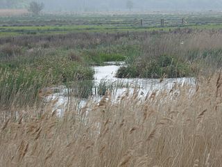
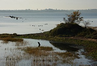
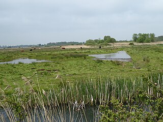
Eilean na Muice Duibhe, also known as Duich Moss, is an area of low-level blanket mire on the island of Islay, off the west coast of Scotland. Located south of the town of Bowmore and with an area of 576 hectares, the area has been protected as a Ramsar Site since 1988. [2]

Mire wetland terrain without forest cover, dominated by living, peat-forming plants

A mire is a wetland type, dominated by living, peat-forming plants. Mires arise because of incomplete decomposition of organic matter, due to waterlogging and subsequent anoxia. Like coral reefs, mires are unusual landforms in that they derive mostly from biological rather than physical processes, and can take on characteristic shapes and surface patterning.

Islay southernmost island of the Inner Hebrides of Scotland

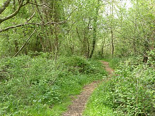
Islay is the southernmost island of the Inner Hebrides of Scotland. Known as "The Queen of the Hebrides", it lies in Argyll just south west of Jura and around 40 kilometres (25 mi) north of the Northern Irish coast. The island's capital is Bowmore where the distinctive round Kilarrow Parish Church and a distillery are located. Port Ellen is the main port.

Scotland country in Northwest Europe, part of the United Kingdom

Scotland is a country that is part of the United Kingdom. Sharing a border with England to the southeast, Scotland is otherwise surrounded by the Atlantic Ocean to the north and west, by the North Sea to the northeast and by the Irish Sea to the south. In addition to the mainland, situated on the northern third of the island of Great Britain, Scotland has over 790 islands, including the Northern Isles and the Hebrides.

The site includes an unusual transition from blanket bog to raised mire habitats. It supports an internationally important population of white-fronted geese, with 2% of the Greenland population overwintering at the site. Breeding birds include the common redshank, red-throated loon and hen harrier. [3]

Common redshank species of bird

The common redshank or simply redshank is a Eurasian wader in the large family Scolopacidae. The genus name Tringa is the New Latin name given to the green sandpiper by Aldrovandus in 1599 based on Ancient Greek trungas, a thrush-sized, white-rumped, tail-bobbing wading bird mentioned by Aristotle. The specific totanus is from Tótano, the Italian name for this bird.

Red-throated loon A migratory aquatic bird found in the northern hemisphere

The red-throated loon or red-throated diver is a migratory aquatic bird found in the northern hemisphere. The most widely distributed member of the loon or diver family, it breeds primarily in Arctic regions, and winters in northern coastal waters. Ranging from 55 to 67 centimetres in length, the red-throated loon is the smallest and lightest of the world's loons. In winter, it is a nondescript bird, greyish above fading to white below. During the breeding season, it acquires the distinctive reddish throat patch which is the basis for its common name. Fish form the bulk of its diet, though amphibians, invertebrates, and plant material are sometimes eaten as well. A monogamous species, the red-throated loon forms long-term pair bonds. Both members of the pair help to build the nest, incubate the eggs, and feed the hatched young.

Hen harrier species of bird

The hen harrier is a bird of prey. The genus name Circus is derived from Ancient Greek kirkos, meaning 'circle', referring to a bird of prey named for its circling flight. The specific cyaneus is Latin, meaning "dark-blue".

As well as being recognised as a wetland of international importance under the Ramsar Convention [2] , Greenlaw Moor has also been designated a Special Protection Area. [1]

Ramsar Convention international treaty for the conservation and sustainable utilization of wetlands

The Ramsar Convention on Wetlands of International Importance especially as Waterfowl Habitat is an international treaty for the conservation and sustainable use of wetlands. It is also known as the Convention on Wetlands. It is named after the city of Ramsar in Iran, where the Convention was signed in 1971.

A Special Protection Area (SPA) is a designation under the European Union Directive on the Conservation of Wild Birds. Under the Directive, Member States of the European Union (EU) have a duty to safeguard the habitats of migratory birds and certain particularly threatened birds. Together with Special Areas of Conservation (SACs), the SPAs form a network of protected sites across the EU, called Natura 2000. Each SPA has an EU code – for example the North Norfolk Coast SPA has the code UK9009031.

Related Research Articles

Ouse Washes nature reserve in the United Kingdom

Ouse Washes is a linear 2,513.6 hectare biological Site of Special Scientific Interest stretching from near St Ives in Cambridgeshire to Downham Market in Norfolk. It is also a Ramsar internationally important wetland site, a Special Protection Area under the European Union Birds Directive, a Special Area of Conservation, and a Nature Conservation Review site, Grade I. An area of 186 hectares between March and Ely is managed by the Wildlife Trust for Bedfordshire, Cambridgeshire and Northamptonshire, and another area near Chatteris is managed by the Royal Society for the Protection of Birds. The Wildfowl & Wetlands Trust manages another area near Welney.

Walmore Common

Walmore Common is a 57.78-hectare (142.8-acre) nature reserve on the flood-plain of the River Severn, west of the city of Gloucester in England and north of the village of Chaxhill. It was notified as a biological Site of Special Scientific Interest in 1966. The site is listed in the 'Forest of Dean Local Plan Review' as a Key Wildlife Site (KWS).

Nene Washes

Nene Washes is a 1,522.1 hectare biological Site of Special Scientific Interest on the bank of the River Nene east of Peterborough in Cambridgeshire. It is also a Ramsar internationally important wetland site, a Special Area of Conservation, a Special Protection Area and a Nature Conservation Review site. An area of 280 hectares is managed by the Royal Society for the Protection of Birds.

Colne Estuary biological and geological Site of Special Scientific Interest near Brightlingsea in Essex

Colne Estuary is a 2915 hectare biological and geological Site of Special Scientific Interest near Brightlingsea in Essex. It is also a Nature Conservation Review site, a National Nature Reserve, a Ramsar wetland site of international importance, a Special Protection Area, a Special Area of Conservation, and a Geological Conservation Review site. Three areas in the site are managed by the Essex Wildlife Trust, Colne Point, Fingringhoe Wick and Howlands Marsh.

Slieve Beagh or Sliabh Beagh is a mountainous area straddling the border between County Monaghan in the Republic of Ireland and County Fermanagh and County Tyrone in Northern Ireland. It includes the highest point in County Monaghan. The point where the three counties meet, which is also in the Sliabh Beagh, is referred to as "Three County Hollow".

Claish Moss is an upland blanket bog on the south side of Loch Shiel, in the Sunart district of the west highlands of Scotland

Castle Marshes Suffolk Wildlife Trust nature reserve

Castle Marshes is a 71 hectare nature reserve west of Lowestoft in Suffolk. It is managed by the Suffolk Wildlife Trust. It is part of the Barnby Broad and Marshes Site of Special Scientific Interest the Broadland Ramsar internationally important wetland site, the Broadland Special Protection Area under the European Union Directive on the Conservation of Wild Birds, and The Broads Special Area of Conservation.

Stour Estuary

Stour Estuary is a 2,523 hectare biological and geological Site of Special Scientific Interest which stretches from Manningtree to Harwich in Essex and Suffolk. It is also an internationally important wetland Ramsar site, a Special Protection Area and a Nature Conservation Review site. It is part of the Suffolk Coast and Heaths Area of Outstanding Natural Beauty, and there are Geological Conservation Review sites in Wrabness, Stutton, and Harwich Part of the site is managed by the Royal Society for the Protection of Birds, and a small area is Wrabness Nature Reserve, a Local Nature Reserve managed by the Essex Wildlife Trust.

Sprats Water and Marshes, Carlton Colville

Sprat's Water and Marshes, Carlton Colville is a 57.1 hectare biological Site of Special Scientific Interest on the western outskirts of Lowestoft in Suffolk. It is part of the Broadland Ramsar internationally important wetland site, and Special Protection Area under the European Union Directive on the Conservation of Wild Birds, and part of The Broads Special Area of Conservation. The northern part of the site is Carlton Marshes, which is part of Carlton and Oulton Marshes, a nature reserve managed by the Suffolk Wildlife Trust.

Carlton and Oulton Marshes Suffolk Wildlife Trust nature reserve

Carlton and Oulton Marshes is a 151 hectare nature reserve in Lowestoft in Suffolk. It is managed by the Suffolk Wildlife Trust. Carlton Marshes is part of the Sprat's Water and Marshes, Carlton Colville Site of Special Scientific Interest, the Broadland Ramsar internationally important wetland site, the Broadland Special Protection Area under the European Union Directive on the Conservation of Wild Birds, and The Broads Special Area of Conservation.

North Cove Nature Reserve Suffolk Wildlife Trust nature reserve

North Cove is a 15.5 hectare nature reserve between Beccles and Lowestoft in Suffolk. It is managed by the Suffolk Wildlife Trust. t is part of the Barnby Broad and Marshes Site of Special Scientific Interest the Broadland Ramsar internationally important wetland site, the Broadland Special Protection Area under the European Union Directive on the Conservation of Wild Birds, and The Broads Special Area of Conservation.

Bridgend Flats is an area of mudflats and saltmarsh near the village of Bridgend on the island of Islay off the west coast of Scotland. Covering an area of 331 hectares, it is situated around the outflow of the River Sorn into Loch Indaal.

Caithness and Sutherland Peatlands Peatland in nothern Scotland

The Caithness and Sutherland Peatlands is a large area of blanket bog and peatland, covering a number of disconnected regions across the historic counties of Caithness and Sutherland in the far north of Scotland, across an area known as the Flow Country. With a total area of 143,503 hectares, it is one of the largest recognised conservation sites in the UK, and is the largest Ramsar Site in Scotland.

Caithness Lochs Series of lochs in northern Scotland

Caithness Lochs is a protected wetland area in the historic county of Caithness in the far north of Scotland. With a total area of 1,379 hectares, it covers six freshwater lochs and a complex area of fen and swamp, and has been protected as a Ramsar Site since 1998.

The Kintyre Goose Roosts are a group of five oligotrophic hill lochs on the Kintyre peninsula in Argyll and Bute, western Scotland. With a total area of 312 hectares, they have been protected as a Ramsar Site since 1998.

The East Sanday Coast is a protected wetland area on and around the island of Sanday, the third-largest of the Orkney islands off the north coast of Scotland. With a total protected area of 1,515 hectares, the 55 kilometre stretch of coast includes rocky and sandy sections, sand dunes, machair habitats, intertidal flats, and saltmarsh. It has been protected as a Ramsar Site since 1997.

Greenlaw Moor is an area of raised heather moorland in the foothills of the Lammermuir Hills, in the Scottish Borders area of Scotland. Located north of the town of Greenlaw and with an area of 248 hectares, the moor has been protected as a Ramsar Site since 1996.

Fala Flow is an area of upland blanket bog on the edge of the Lammermuir Hills, in Midlothian, Scotland. Located north of the village of Fala, around 15km south east of Edinburgh, an area of 318 hectares has been designated as a Ramsar Site since 1990.

References

  1. 1 2 "Eilean na Muice Duibhe (Duich Moss), Islay". Joint Nature Conservation Committee. Retrieved 7 March 2019.
  2. 1 2 "Eilean Na Muice Duibhe". Ramsar Sites Information Service. Retrieved 7 March 2019.
  3. "Information Sheet on Ramsar Wetlands" (PDF). Joint Nature Conservation Committee. Retrieved 7 March 2019.