The Coral Sea Islands Territory is an external territory of Australia which comprises a group of small and mostly uninhabited tropical islands and reefs in the Coral Sea, northeast of Queensland, Australia. The only inhabited island is Willis Island. The territory covers 780,000 km2 (301,160 sq mi), most of which is ocean, extending east and south from the outer edge of the Great Barrier Reef and includes Heralds Beacon Island, Osprey Reef, the Willis Group and fifteen other reef/island groups. Cato Island is the highest point in the Territory.

İmralı is a small Turkish island in the south of the Sea of Marmara, west of the Armutlu-Bozburun peninsula within Bursa Province. It measures 8 kilometres in the north-south direction with a width of 3 kilometres, and has an area of 9.98 square kilometres (3.85 sq mi). The highest peak is Türk Tepesi at an altitude of 217 metres above sea level. It is currently a prison island, so it is prohibited to fly over the island or fish near its shores.
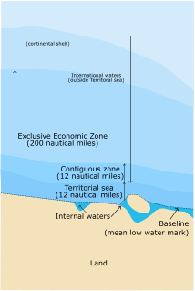
An exclusive economic zone (EEZ) is a sea zone prescribed by the United Nations Convention on the Law of the Sea over which a state has special rights regarding the exploration and use of marine resources, including energy production from water and wind. It stretches from the baseline out to 200 nautical miles (nmi) from its coast. In colloquial usage, the term may include the continental shelf. The term does not include either the territorial sea or the continental shelf beyond the 200 nmi limit. The difference between the territorial sea and the exclusive economic zone is that the first confers full sovereignty over the waters, whereas the second is merely a "sovereign right" which refers to the coastal state's rights below the surface of the sea. The surface waters, as can be seen in the map, are international waters.

Antikythera or Anticythera is a Greek island lying on the edge of the Aegean Sea, between Crete and Peloponnese. Since the 2011 local government reform it is part of the municipality of Kythera island.

Elafonisos is a small Greek island between the Peloponnese and Kythira. It lies off the coast of Cape Malea and Vatika. The area of the island is 19 square kilometres.

Fournoi Korseon or Fournoi Ikarias, more commonly simply Fournoi (Greek: Φούρνοι; anciently, it was known as Corsiae or Korsiai is a complex or archipelago of small Greek islands that lie between Ikaria, Samos and Patmos in Ikaria regional unit, North Aegean region. The two largest islands of the complex, the main isle of Fournoi 31 square kilometres and the isle of Thymaina 10 square kilometres, are inhabited, as is Agios Minas Island 2.3 square kilometres to the east. The municipality has an area of 45.247 km2. On the main isle Fournoi is the largest settlement and then Chrysomilia in the north the second largest. Fournoi proper is the main ferry harbour, with ferries also landing on Thymaina.
The island of Koločep is one of the three inhabited Elaphiti Islands situated near the city of Dubrovnik with an area of 2.44 square kilometres. Koločep is the southernmost inhabited island in Croatia and is locally known as Kalamota. In the 2011 census, the population of the island was 163.

Tenarunga or Tenania, formerly Minto Island is a low, wooded and uninhabited atoll in the Acteon Group in the southeastern part of the Tuamotu Islands in French Polynesia. It is administratively a part of the Gambier Islands.

Strongyli Megistis, also called plainly Strongyli or Ypsili, is a Greek islet which lies in the eastern Mediterranean Sea, about four kilometers south-east of the island of Kastellorizo. The island is about 1.5 kilometres long, and up to 700 metres (2,300 ft) wide. It covers an area of about 0.9 square kilometres (0.3 sq mi). It is rather flat and covered with macchia. The islet has no permanent residents.

Agathonísi is a small Greek island and municipality located at the northernmost point of the Dodecanese in Greece. It is surrounded by many smaller islands and is home to two villages, both inland; Megálo Chorió, and Mikró Chorió. Between them is the small settlement of Agios Georgios, which forms the island's only harbor and consists of a few hotels and restaurants. The island is also locally known as Gaidaro ("Donkey"), or by its ancient name Tragea.

Kastos is a Greek island and a former community east of the island of Lefkada, Ionian Islands, Greece. Since the 2011 local government reform it is part of the municipality Lefkada, of which it is a municipal unit. Until 1974, when it became part of the Lefkada Prefecture, the island was administered under the Cephalonia Prefecture. The nearest island is Kalamos, with a deep channel between them; the mainland is approximately 5 kilometres to the northeast in Aetolia-Acarnania.

St. Thomas Island or Zmiyski ostrov ), is a Bulgarian island in the Black Sea, 15 kilometres south of Sozopol. It has an area of 0.012 square kilometres and is one of a very few places in Bulgaria where wild cacti grow. The Opuntia cacti were brought from the Botanical Garden in Bratislava, Slovakia and planted by the royal botanist Ivan Buresh on the orders of Tsar Boris III in 1933. They have covered most of the island since then.

Koufonisi is an uninhabited Greek islet, located 3 nautical miles south of cape Goudero on the coast of Lasithi, eastern Crete, in the Libyan Sea. The island is roughly 6 kilometres long and 5.5 kilometres across. It has an entire surface area of 5.25 square kilometres (2.03 sq mi). It forms a close group of islands with Makroulo, Marmaro, Strongyli, and Trachilos.
St. François Atoll is one of two atolls of the Alphonse Group in the Seychelles that are part of the Outer Islands.

İç Ada is a Turkish islet near Kaş, in the homonymous district of Antalya province. It lies in the eastern Mediterranean Sea, about five nautical miles west-southwest of the island of Kekova, and about halfway between Kekova and the Greek islet of Stroggyli. The island has the shape of a right triangle elongated along a northeast-southwest axis, whose legs are 2.5 kilometres and 1.2 kilometres long. It is separated by the mainland by a 150 metres wide strait. Iç Ada is uninhabited and is covered with macchia.

Kamaka is an island in the Gambier Islands of French Polynesia, 11.7 km south of Mangareva within the same lagoon. Kamaka is about one kilometre in length, 700 metres wide, and has an area of 0.5 square kilometres. The highest point is 166 metres above sea level.
Alimia or Alimnia is a Greek island of the Aegean Sea, located in the sea area between Rhodes and Halki, the complex of Dodecanese. The surface of the island is 7.4 square kilometres and has a coastline of 21 kilometres. The island had a small population until the period of the Second World War, and in recent decades has remained uninhabited.

Insular Chile, also called Las islas Esporádicas, or "the Sporadic Islands", is a scattered group of oceanic islands of volcanic origin located in the Chilean Sea, at some distance from mainland Chile, and which are under the sovereignty of Chile.

Büyük Ilyosta Island is an Aegean island of Turkey. The name of the island is a corrupt form of a Greek name Eleos.