Elizabeth Township, New Jersey

Last updated

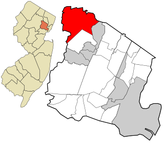
Elizabeth Township, also called Elizabethtown, was a township that existed in Essex County, in the U.S. state of New Jersey, from 1664 until 1855.

A township, in the context of New Jersey local government, refers to one of five types and one of eleven forms of municipal government. As a political entity, a township in New Jersey is a full-fledged municipality, on par with any town, city, borough, or village. They collect property taxes and provide services such as maintaining roads, garbage collection, water, sewer, schools, police and fire protection. The Township form of local government is used by 27% of New Jersey municipalities; however, slightly over 50% of the state's population resides within them.

Essex County, New Jersey County in the United States

Essex County is a county in the northeastern part of the U.S. state of New Jersey. As of the 2017 Census estimate, the county's population was 808,285, making it the state's third-most populous county, an increase of 3.1% from the 2010 United States Census, when its population was enumerated at 783,969, in turn a decrease of 1.2% from the 793,633 enumerated in the 2000 Census. In 2010, the county dropped down to third-largest, behind Middlesex County, and was one of only two counties in the state to see a decline between 2000 and 2010. Its county seat is Newark, the most populous city in the state. It is part of the New York Metropolitan Area.

U.S. state constituent political entity of the United States

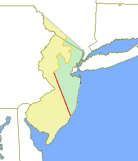
In the United States, a state is a constituent political entity, of which there are currently 50. Bound together in a political union, each state holds governmental jurisdiction over a separate and defined geographic territory and shares its sovereignty with the federal government. Due to this shared sovereignty, Americans are citizens both of the federal republic and of the state in which they reside. State citizenship and residency are flexible, and no government approval is required to move between states, except for persons restricted by certain types of court orders. Four states use the term commonwealth rather than state in their full official names.

The area was initially part of the Elizabethtown Tract, purchased from the Lenape on October 28, 1664. [1]

The Elizabethtown Tract was a property that was purchased on October 28, 1664, by John Baily, Daniel Denton and Luke Watson from the Native Americans that is in the area of present-day Elizabeth, New Jersey. The Native American witnesses to the treaty gave their names as Warinanco and Mattano. As specified in the Deed, the purchase included the area "Bounded on the South by a River commonly called the Raritons River, and on the East by the River which Parts Staten-Island and the Main, and to run Northward up after Cull-Bay, till we come at the first River which sets Westwards up after Cull-Bay." The territory encompassed lands from the mouth of the Raritan River and included all of present-day Union County as well as parts of Somerset, Middlesex, Morris and Essex counties.

Lenape indigenous people originally from Lenapehoking, now the Mid-Atlantic United States

The Lenape, also called the Leni Lenape, Lenni Lenape and Delaware people, are an indigenous people of the Northeastern Woodlands, who live in Canada and the United States. Their historical territory included present-day New Jersey and eastern Pennsylvania along the Delaware River watershed, New York City, western Long Island, and the Lower Hudson Valley. Today, Lenape people belong to the Delaware Nation and Delaware Tribe of Indians in Oklahoma; the Stockbridge-Munsee Community in Wisconsin; and the Munsee-Delaware Nation, Moravian of the Thames First Nation, and Delaware of Six Nations in Ontario.

Elizabeth-Town Township was formed on October 31, 1693, while the area was still within Essex County. Elizabeth was incorporated as one of New Jersey's initial 104 townships by the Township Act of 1798 Act of the New Jersey Legislature on February 21, 1798. Portions of the township were taken to form Westfield Township (January 27, 1794), Springfield Township (April 14, 1794), Rahway Township (February 27, 1804) and Clinton Township (April 14, 1834). [1]

The Township Act of 1798 is an Act passed by New Jersey Legislature on February 21, 1798 that formally incorporated 104 municipalities in 13 counties in New Jersey. It set standards on format for government of townships. The act was largely replaced by subsequent laws.

New Jersey Legislature the legislature of the U.S. state of New Jersey

The New Jersey Legislature is the legislative branch of the government of the U.S. state of New Jersey. In its current form, as defined by the New Jersey Constitution of 1947, the Legislature consists of two houses: the General Assembly and the Senate. The Legislature meets in the New Jersey State House, in the state capital of Trenton. Democrats currently hold super majorities in both chambers of the legislature.

Westfield, New Jersey Town in New Jersey, United States

Westfield is a town in Union County of New Jersey, United States. As of the 2010 United States Census, the town's population was 30,316, reflecting an increase of 672 (+2.3%) from the 29,644 counted in the 2000 Census, which had in turn increased by 774 (+2.7%) from the 28,870 counted in the 1990 Census. In March 2018, Bloomberg ranked Westfield as the 99th wealthiest place in the United States, and the 18th wealthiest in New Jersey. According to a 2014 nationwide survey, Westfield is considered to be the 30th-safest city to live in the United States.

On March 13, 1855, the City of Elizabeth was created, combining and replacing both Elizabeth Township and Elizabeth Borough. With the creation of the City of Elizabeth, Elizabeth Township was dissolved. [1]

Elizabeth, New Jersey City in New Jersey

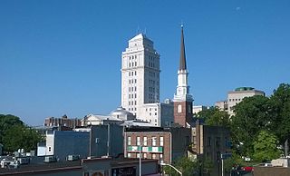
Elizabeth is both the largest city and the county seat of Union County, in New Jersey, United States. As of the 2010 United States Census, the city had a total population of 124,969, retaining its ranking as New Jersey's fourth most populous city, behind Paterson. The population increased by 4,401 (3.7%) from the 120,568 counted in the 2000 Census, which had in turn increased by 10,566 (+9.6%) from the 110,002 counted in the 1990 Census. For 2017, the Census Bureau's Population Estimates Program calculated a population of 130,215, an increase of 4.2% from the 2010 enumeration, ranking the city the 212th-most-populous in the nation.

Elizabeth Borough was a borough that existed in Essex County, in the U.S. state of New Jersey, from 1740 until 1855.

Related Research Articles

Fairfield Township, Essex County, New Jersey Township in New Jersey

Fairfield is a township in far northwestern Essex County, New Jersey, United States. As of the 2010 United States Census, the township's population was 7,466, reflecting an increase of 403 (+5.7%) from the 7,063 counted in the 2000 Census, which had in turn declined by 552 (-7.2%) from the 7,615 counted in the 1990 Census. Fairfield is the least densely populated town in Essex County.

East Jersey English possession in North America between 1674 and 1702

The Province of East Jersey, along with the Province of West Jersey, between 1674 and 1702 in accordance with the Quintipartite Deed were two distinct political divisions of the Province of New Jersey, which became the U.S. state of New Jersey. The two provinces were amalgamated in 1702. East Jersey's capital was located at Perth Amboy. Determination of an exact location for a border between West Jersey and East Jersey was often a matter of dispute.

Clinton Hill, Newark human settlement in United States of America

Clinton Hill is a neighborhood within the south-central portion of the city of Newark in Essex County, New Jersey, United States. It is centered at Clinton Avenue, and bounded roughly by Elizabeth Avenue in the east, Hawthorne Avenue in the south, Avon Avenue in the north, and Irvington in the west.

Acquackanonk Township, New Jersey Township

Acquackanonk Township was a township that existed in New Jersey, United States, from 1693 until 1917, first in Essex County and then in Passaic County.

New Barbadoes Township was a township that was formed in 1710 and existed in its largest extent in pre-American Revolutionary War times in Bergen County, New Jersey. The Township was created from territories that had been part of Essex County that were removed by royal decree and added to Bergen County. After many departures, secessions and deannexations over the centuries, New Barbadoes Township exists today as Hackensack, which adopted its present name in 1921.

Amwell Township was a Township that existed in Hunterdon County, New Jersey, United States, from 1708 to 1846.

Bergen Township was a township that existed in the U.S. state of New Jersey, from 1661 to 1862, first as Bergen, New Netherland, then as part Bergen County, and later as part of Hudson County. Several places still bear the name: the township of North Bergen; Bergen Square, Old Bergen Road, Bergen Avenue, Bergen Junction, Bergen Hill and Bergen Arches in Jersey City; Bergen Point in Bayonne; and Bergenline Avenue and Bergen Turnpike in North Hudson.

Pompton Township is a defunct township in Passaic County, New Jersey, United States, that existed from 1797 until it was dissolved in 1918.

Nottingham Township was a township that existed for almost 168 years in New Jersey, from 1688 until it was dissolved in 1856.

Clinton Township was a township located in Essex County, New Jersey, United States, which existed from 1834 to 1902.

Newton Township was a township in New Jersey, United States, that existed initially within Gloucester County from its creation in 1695, and became part of Camden County when that county was formed in 1844, where it existed until its dissolution in 1871.

Newton Township is a defunct township that was located in Sussex County, in northwestern New Jersey, in the United States. The township was established as a precinct in 1751, the township is first mentioned in a description of its boundaries in the sessions of the Court of Common Pleas in Morris County. Before the establishment of Sussex County on 8 June 1753, Morris County controlled the sparsely populated areas in the northwestern corner of New Jersey and spanned the territory of three present-day New Jersey counties: Morris, Sussex, and Warren. After ceding territory on several occasions new municipalities were created, Newton Township ceased to exist on 11 April 1864.

Woodside was a township that existed in Essex County, New Jersey, United States, from 1869 to 1871. Woodside was incorporated as a township by an Act of the New Jersey Legislature on March 24, 1869, from portions of Belleville Township On April 5, 1871, almost two weeks after its second anniversary, the township was dissolved, and its territory was absorbed by Belleville and Newark. Today, Woodside is Newark's northeasternmost neighborhood.

Bergen was a city that existed in Hudson County, New Jersey, United States, from 1855 to 1870.

Hudson City, New Jersey

Hudson was a city that existed in Hudson County, New Jersey, United States, from 1855 to 1870 when it became part of Jersey City.

Union Hill was a town that existed in Hudson County, New Jersey, United States, from 1864 to June 1, 1925, when it merged with West Hoboken to form Union City.

Rahway Township was a township in New Jersey, United States, that existed from 1804 until it was dissolved in 1861.

Plainfield Township was a township in New Jersey, United States, that existed from 1847 until it was dissolved in 1878.

References

  1. 1 2 3 Snyder, John P. The Story of New Jersey's Civil Boundaries: 1606-1968, Bureau of Geology and Topography; Trenton, New Jersey; 1969. p. 238. Accessed November 3, 2012.

Coordinates: 40°40′16″N74°12′40″W / 40.671°N 74.211°W / 40.671; -74.211

Geographic coordinate system Coordinate system

A geographic coordinate system is a coordinate system that enables every location on Earth to be specified by a set of numbers, letters or symbols. The coordinates are often chosen such that one of the numbers represents a vertical position and two or three of the numbers represent a horizontal position; alternatively, a geographic position may be expressed in a combined three-dimensional Cartesian vector. A common choice of coordinates is latitude, longitude and elevation. To specify a location on a plane requires a map projection.