Erimi

Last updated
Erimi

Ερήμη
Country Cyprus
District Limassol District
Government
   Mayor Panicos Hadjichambis
Population
 (2001 [1] )
  Total1,432
Time zone UTC+2 (EET)
  Summer (DST) UTC+3 (EEST)
Postal code
4630
Website http://www.thevillagexpress.com/cyprusvillage/profile/189

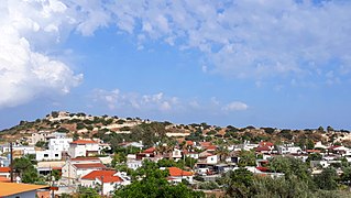
Erimi is a village lying partly in the Limassol District of Cyprus and partly in the British Overseas Territory of Akrotiri and Dhekelia. It has a population of 1,432 according to the 2001 census. It has recently[ citation needed ] increased in size with the addition of the district "Aphrodite Gardens", a new area just developed for expatriates of mainly British origin.

Limassol District District in Cyprus

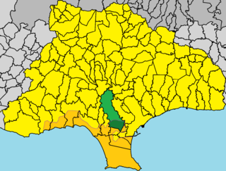
Limassol District or Lemesos is one of the six districts of Cyprus. As of 2011, it had a population of 239.842, 77% of which was urban. Its main city is Limassol. Part of the British Overseas Territory of Akrotiri and Dhekelia forms an enclave on the Akrotiri Peninsula, under the sovereignty of the United Kingdom.

Cyprus Island country in the Mediterranean

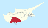
Cyprus, officially the Republic of Cyprus, is an island country in the Eastern Mediterranean and the third largest and third most populous island in the Mediterranean, located south of Turkey, west of Syria and Lebanon, northwest of Israel and Palestine, north of Egypt, and southeast of Greece.

Akrotiri and Dhekelia British Overseas Territory

The Sovereign Base Areas of Akrotiri and Dhekelia is a British Overseas Territory on the island of Cyprus. The areas, which include British military bases and installations, as well as other land, were retained by the British under the 1960 treaty of independence, signed by the United Kingdom, Greece, Turkey and representatives from the Greek and Turkish Cypriot communities, which granted independence to the Crown colony of Cyprus. The territory serves an important role as a station for signals intelligence and provides a vital strategic part of the United Kingdom communications gathering and monitoring network in the Mediterranean and the Middle East. The United States may have a significant presence in these territories.

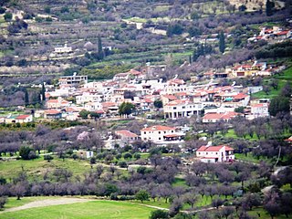
Close to Erimi is the village of Kolossi, which is where one can find the castle of Kolossi.

Kolossi Place in Limassol District, Cyprus

Kolossi is a village on the outskirts of Limassol, Cyprus. It lies partly in the British Overseas Territory of Akrotiri and Dhekelia. Its population in 2011 was 5,651.

Cyprus Wine Museum

The Cyprus Wine Museum (Οινομουσείο) is situated in Erimi village at the crossroads of the wine routes leading to the mountains and on the old road between Limassol and Paphos.[ citation needed ]

Paphos Place in Paphos District, Cyprus

Paphos, sometimes spelled Pafos, is a coastal city in the southwest of Cyprus and the capital of Paphos District. In antiquity, two locations were called Paphos: Old Paphos, today at Kouklia, and New Paphos.

The Cyprus Wine Museum, using traditional and contemporary methods presents a journey through centuries of Cyprus wine history. Ancient jars and vases, medieval drinking vessels, the private collection of Anastasia Guy, old documents and instruments illustrate how wine was produced, stored and enjoyed in the past. Photographic backdrops and audiovisual equipment bring all aspects of wine making to life, from cultivation to production.

Related Research Articles

Kolossi Castle

Kolossi Castle is a former Crusader stronghold on the south-west edge of Kolossi village 14 kilometres (9 mi) west of the city of Limassol on the island of Cyprus. It held great strategic importance in the Middle Ages, and contained large facilities for the production of sugar from the local sugarcane, one of Cyprus's main exports in the period. The original castle was possibly built in 1210 by the Frankish military, when the land of Kolossi was given by King Hugh I to the Knights of the Order of St John of Jerusalem (Hospitallers).

Pissouri Place in Limassol District, Cyprus

Pissouri is a village located in Limassol’s district, Cyprus, between Limassol and Paphos. Pissouri’s administrative area is the third biggest in Limassol District. The main settlement of Pissouri is situated about three kilometres away from the bay named Cape Aspro, and is built on the side of a green hill. The settlement, strangely, is placed in the middle of Pissouri’s territory.

Pachna Place in Limassol District, Cyprus

Pachna is a village in the Limassol District of the Republic of Cyprus. It is situated on the south slopes of the Troödos mountain range at an altitude of 745 m (2447 ft).

Omodos Place in Limassol District, Cyprus

Omodos is a village in the Troödos Mountains of Cyprus. It is also located in the Limassol District of Cyprus and is 80 kilometers from the city of Nicosia. The village produces a lot of wine and holds a wine festival every August. You can visit a 17th-century stone-built monastery via a cobblestone path and sample local wine for free at many outlets. You will also find a good mix of restaurants including traditional tavernas and a few modern bars housed in traditional buildings.

Marathassa Valley is a beautiful and fertile valley in the Troödos Mountains of Cyprus. It takes its name from the plant Marathos, a type of fennel which grows in the area.

Kalo Chorio, Limassol Place in Limassol District, Cyprus

Kalo Chorio is a village located 21 kilometres (13 mi) north of Limassol in Cyprus. It is best known for its production of Commandaria wine. The name translates word for word as good village.

Cypriot wine The wine production of Cyprus

The Cypriot wine industry ranks 50th in the world in terms of total production quantity ., and much higher on a per capita basis. Although, chronologically, Cyprus belongs to the Old World of wine-producing countries, the industry has gone through changes that place it more on par with the New World. The wine industry is a significant contributor to the Cypriot economy through cultivation, production, employment, export and tourism.

Avdimou Place in Limassol District, Cyprus

Avdimou is a small village on the south coast of Cyprus, lying partly within the British Overseas Territory of Akrotiri and Dhekelia. Up to 1974 it was inhabited by a majority of Turkish-Cypriots, but following the Turkish invasion the Turkish Cypriot residents were forcibly evacuated to the North. Greek Cypriot refugees from the North, who were also forcibly evacuated, replaced the Turkish residents.

Ypsonas municipality of Limassol District, Republic of Cyprus

Ypsonas is a municipality in Limassol prefecture of the Republic of Cyprus. It is one of the largest villages in the Limassol District of Cyprus and is located about 7 kilometers west of Limassol city. The southern part of the village is within the administrative borders of the British military base of Akrotiri - Episkopi. It has 10,916 residents as recorded in the Census of 2011.

Armenochori, Cyprus village in Limassol District, Cyprus

Armenochori is an Armenian village located in the Limassol District of Cyprus, 10 kilometres northeast of the city of Limassol. Armenochori means “Armenian village” in Greek. In 1958, the Turkish Cypriots adopted the alternative name Esenköy, literally meaning “windy village.”

Koilani Place in Limassol District, Cyprus

Koilani is a village in the Limassol District of Cyprus, located 3 km south of Pera Pedi.

Malia, Cyprus Place in Limassol District, Cyprus

Malia is a village in the Limassol District of Cyprus, located 4 km south of Omodos.

Agios Therapon village in Limassol District, Cyprus

Agios Therapon is a village in the Limassol District of Cyprus, located 20 km north of Erimi.

Pano Kivides village in Limassol District, Cyprus

Pano Kivides is a village in the Limassol District of Cyprus, located 10 km north of Erimi. Pano Kivides that '80 moved to the current location.

Silikou Village in Limassol District, Cyprus

Silikou is a village in the Limassol District of Cyprus, located 5 km south of Pera Pedi.

Limnatis, Limassol village in Limassol District, Cyprus

Limnatis is a village in the Limassol District of Cyprus, located 5 km south of Agios Mamas.

Kantou, Cyprus Place in Limassol District, Cyprus

Kantou is a village in the Limassol District of Cyprus, located 2 km north of Erimi. Prior to 1960, the village was almost exclusively inhabited by Turkish Cypriots.

References

  1. Statistical Service of the Republic of Cyprus , 2001 Population Census. MS Excel document.

Coordinates: 34°41′N32°55′E / 34.683°N 32.917°E / 34.683; 32.917

Geographic coordinate system Coordinate system

A geographic coordinate system is a coordinate system that enables every location on Earth to be specified by a set of numbers, letters or symbols. The coordinates are often chosen such that one of the numbers represents a vertical position and two or three of the numbers represent a horizontal position; alternatively, a geographic position may be expressed in a combined three-dimensional Cartesian vector. A common choice of coordinates is latitude, longitude and elevation. To specify a location on a plane requires a map projection.