
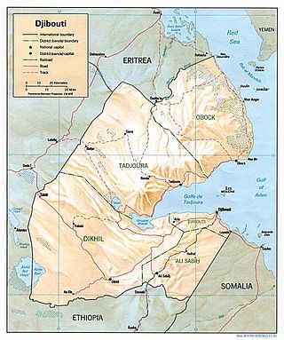
Djibouti is a country in the Horn of Africa. It is bordered by Eritrea in the north, Ethiopia in the west and south, and Somalia in the southeast. To the east is its coastline on the Red Sea and the Gulf of Aden. Rainfall is sparse, and most of the territory has a semi-arid to arid environment. Lake Assal is a saline lake which lies 155 m (509 ft) below sea level, making it the lowest point on land in Africa and the third-lowest point on Earth after the Sea of Galilee and the Dead Sea. Djibouti has the fifth smallest population in Africa. Djibouti's major settlements include the capital Djibouti City, the port towns of Tadjoura and Obock, and the southern cities of Ali Sabieh and Dikhil. It is the forty-six country by area in Africa and 147st largest country in the world by land area, covering a total of 23,200 km2 (9,000 sq mi), of which 23,180 km2 (8,950 sq mi) is land and 20 km2 (7.7 sq mi) is water.

Eritrea is located in the Horn of Africa and is bordered on the northeast and east by the Red Sea, on the west and northwest by Sudan, on the south by Ethiopia, and on the southeast by Djibouti. The country has a high central plateau that varies from 1,800 to 3,000 meters (5,906–9,843 ft) above sea level. A coastal plain, western lowlands, and some 350 islands comprise the remainder of Eritrea's land mass.

The Sahel region or Sahelian acacia savanna is a biogeographical region in Africa. It is the transition zone between the more humid Sudanian savannas to its south and the drier Sahara to the north. The Sahel has a hot semi-arid climate and stretches across the southernmost latitudes of North Africa between the Atlantic Ocean and the Red Sea. Although geographically located in the tropics, the Sahel does not have a tropical climate.

The Arabian Desert is a vast desert wilderness in West Asia that occupies almost the entire Arabian Peninsula with an area of 2,330,000 square kilometers (900,000 sq mi). It stretches from Yemen to the Persian Gulf and Oman to Jordan and Iraq. It is the fifth largest desert in the world and the largest in Asia. At its center is Ar-Rub' al-Khali, one of the largest continuous bodies of sand in the world. It is an extension of the Sahara Desert.

The dorcas gazelle, also known as the ariel gazelle, is a small and common gazelle. The dorcas gazelle stands about 55–65 cm at the shoulder, with a head and body length of 90–110 cm and a weight of 15–20 kg. The numerous subspecies survive on vegetation in grassland, steppe, wadis, mountain desert and in semidesert climates of Africa and Arabia. About 35,000–40,000 exist in the wild.

The antilopines are even-toed ungulates belonging to the subfamily Antilopinae of the family Bovidae. The members of tribe Antilopini are often referred to as true antelopes, and include the gazelles, blackbucks, springboks, gerenuks, dibatags, and Central Asian gazelles. True antelopes occur in much of Africa and Asia, with the highest concentration of species occurring in East Africa in Sudan, Eritrea, Ethiopia, Somalia, Kenya, and Tanzania. The saiga inhabits Central and Western Asia, mostly in regions from the Tibetan Plateau and north of the Indian Subcontinent. The dwarf antelope species of tribe Neotragini live entirely in sub-Saharan Africa.

The East Saharan montane xeric woodlands is an ecoregion of central Africa, a number of high mountains in the middle of the huge area of savanna on the edge of the Sahara Desert.
The wildlife of Djibouti, consisting of its flora and fauna, is in a harsh landscape with forest accounting for less than one percent of its area. Most species are found in the northern part of the country in the Day Forest National Park at an average elevation of 1,500 metres (4,900 ft), including the massif Goda, with a peak of 1,783 metres (5,850 ft). It covers an area of 3.5 square kilometres (1.4 sq mi) of Juniperus procera forest, with many of the trees rising to 20 metres (66 ft) height. This forest area is the main habitat of the critically endangered and endemic Djibouti spurfowl, and another recently noted vertebrate, Platyceps afarensis. The area also contains many species of woody and herbaceous plants, including boxwood and olive trees, which account for sixty percent of the identified species in the country.
Mauritania's wildlife has two main influences as the country lies in two biogeographic realms. The north sits in the Palearctic which extends south from the Sahara to roughly 19° north latitude and the south is in the Afrotropic realm. Additionally, Mauritania is an important wintering area for numerous birds which migrate from the Palearctic.

The wildlife of Libya is spread over the Mediterranean coastline and encompasses large areas of the Saharan desert. The protection of wildlife is provided through appropriate legislation in seven national parks, five reserves, 24 protected areas, two wetlands under Ramsar Convention, and also in other areas. Apart from these, there are also five UNESCO World Heritage Sites related to culture. The most important national parks are the El-Kouf National Park and Karabolli National Park. The well known nature reserves are the Benghazi Reserve and the Zellaf Reserve. The wildlife species recorded in the country are 87 mammals and 338 species of birds.

The Atlantic coastal desert is the westernmost ecoregion in the Sahara Desert of North Africa. It occupies a narrow strip along the Atlantic coast, where the more frequent fog and haze generated offshore by the cool Canary Current provides sufficient moisture to sustain a variety of lichens, succulents, and shrubs.

The South Saharan steppe and woodlands, also known as the South Sahara desert, is a deserts and xeric shrublands ecoregion of northern Africa. This band is a transitional region between the Sahara's very arid center to the north, and the wetter Sahelian Acacia savanna ecoregion to the south. In pre-modern times, the grasslands were grazed by migratory gazelles and other ungulates after the rainfalls. More recently, over-grazing by domestic livestock have degraded the territory. Despite the name of the ecoregion, there are few 'woodlands' in the area; those that exist are generally acacia and shrubs along rivers and in wadis.

The Arabian Peninsula coastal fog desert, also known as the Southwestern Arabian coastal xeric scrub, is desert ecoregion on the southern coasts of the Arabian Peninsula, which experiences thick fogs where visibility may be reduced to 10 metres (33 ft). It is classed as an Afrotropical fog desert

The Djibouti Xeric Shrublands ecoregion is a semi-desert strip on or near the Red Sea and the Gulf of Aden coasts in Eritrea, Ethiopia, Djibouti and Somalia. This ecoregion lies mainly between sea level and 800 meters (m) elevation. There are, however, many hills and massifs, which range up to 1300 m as well as outstanding fault-induced depressions, such as the Danakil, lying as low as 155 m below sea level. This region is extremely active tectonically, experiencing many earthquakes and intermittently active volcanoes. Rainfall is very low and yearly averages range from 100 to 200 millimeters (mm), with less rain falling closer to the coast. There are many species of interest, including the endemic Archer's lark, a species of dragon tree, and a large suite of desert ungulates, including the last viable population of African wild ass.

The Gulf of Oman desert and semi-desert is a coastal ecoregion on the Persian Gulf and the Gulf of Oman in Oman and the United Arab Emirates at the northeastern tip of the Arabian Peninsula. The climate is hot and dry, with gravelly plains and savanna with thorny acacia trees inland from the coast. Along the coast there are mixture of habitats that include mangrove swamps, lagoons and mudflats. The mangrove areas are dominated by Avicennia marina and the savanna by Prosopis cineraria and Vachellia tortilis. Masirah Island is an important breeding area for the loggerhead sea turtle and other sea turtles also occur here, as well as a great variety of birds, some resident and some migratory. There are some protected areas, but in general the habitats have been degraded by the grazing of livestock, especially camels and goats; they are also at risk from oil spills, off-road driving and poaching.

The Hobyo grasslands and shrublands is a desert and xeric scrubland ecoregion in Somalia. The ecoregion includes a belt of coastal dunes, 10 to 15 km wide, along the Indian Ocean coast, extending from north of Hobyo to south of Mogadishu.
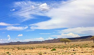
The Grand Bara, Bara Wein or Bada Wein, is a desert in southern Djibouti. It consists of large areas of sand flats, with sparse, semi-desert and desert grasses and scrub vegetation. A road built in 1981 passes through the area, connecting the capital Djibouti City with the south. Prior to the arrival of the French, the extremely arid interior was inhabited primarily by the Issa Somali. Runners make their way across the Grand Bara Desert during the Annual Grand Bara 15K race.

The Somali Acacia–Commiphora bushlands and thickets is a semi-arid tropical grasslands, savannas, and shrublands ecoregion in the Horn of Africa. It is home to diverse communities of plants and animals, including several endemic species.

The Somali montane xeric shrublands is a desert and xeric scrubland ecoregion in Somalia. The ecoregion lies in the rugged Karkaar Mountains, which run parallel and close to Somalia's northern coast on the Gulf of Aden, and follows coast from Cape Guardafui south to Eyl on the Arabian Sea.

The Red Sea coastal desert is deserts and xeric shrublands ecoregion of Egypt and Sudan.

