See also
- Extreme points of India, shares border with Bangladesh
- Extreme points of Myanmar, shares border with Bangladesh
- Bangladesh-India border
- Bangladesh-Myanmar border
Here is a list of the extreme points and extreme elevations in Bangladesh
| Heading | Location | Administrative entity | Bordering entity |
|---|---|---|---|
| Northernmost | Banglabandha | Tetulia Upazila, Panchagarh District | Siliguri, West Bengal, India |
| Southernmost | Chhera Dwip, St. Martin's Island | Teknaf Upazila, Cox's Bazar District | Bay Of Bengal |
| Southernmost(mainland) | Shah Parir Dwip Cape, Teknaf Peninsula | Teknaf Upazila, Cox's Bazar District | Bay Of Bengal, Naf River |
| Easternmost | Akhainthong | Thanchi Upazila, Bandarban District | Mindat District, Chin State, Myanmar |
| Westernmost | Manakosa Union | Shibganj Upazila, Chapai Nawabganj District | Kaliachak, Malda District, West Bengal, India |
| Extremity | Name | Elevation | Location | Division |
|---|---|---|---|---|
| Highest | Saka Haphong | 1,052 m (3,451 ft) | Thanchi Upazila, Bandarban District | Chittagong Division |
| Lowest | Swatch of no ground | −900 m (−2,952.8 ft) | near Dublar Char, Shyamnagar Upazila, Satkhira District | near Khulna Division |

The Rohingya people are a stateless Indo-Aryan ethnic group who predominantly follow Islam and reside in Rakhine State, Myanmar. Before the Rohingya genocide in 2017, when over 740,000 fled to Bangladesh, an estimated 1.4 million Rohingya lived in Myanmar. Described by journalists and news outlets as one of the most persecuted minorities in the world, the Rohingya are denied citizenship under the 1982 Myanmar nationality law. There are also restrictions on their freedom of movement, access to state education and civil service jobs. The legal conditions faced by the Rohingya in Myanmar have been compared to apartheid by some academics, analysts and political figures, including Nobel laureate Bishop Desmond Tutu, a South African anti-apartheid activist. The most recent mass displacement of Rohingya in 2017 led the International Criminal Court to investigate crimes against humanity, and the International Court of Justice to investigate genocide.
Indira Point, the southernmost point of India's territory, is a village in the Nicobar district at Great Nicobar Island of Andaman and Nicobar Islands in India. It is located in the Great Nicobar tehsil.

The Border Guard Bangladesh (BGB) is a paramilitary force responsible for the border security of Bangladesh. The BGB is entrusted with the responsibility to defend the 4,427 kilometres (2,751 mi) border of Bangladesh with India and Myanmar. It was formerly known as the Bangladesh Rifles (BDR).

Tlabung, formerly known as Demagiri, is a census town in Lunglei district in the Indian state of Mizoram.
The Coco Islands are a small group of islands in the northeastern Bay of Bengal. They are part of the Yangon Region of Myanmar since 1937. The islands are located 414 km (257 mi) south of the city of Yangon. Coco Island group consists of five islands: four on the Great Coco Reef and one on the Little Coco Reef. To the north of this island group lies Preparis Island, belonging to Myanmar. To the south lies the Landfall Island, belonging to India.
The Ministry of Development of North Eastern Region is a Government of India ministry, established in September 2001, which functions as the nodal Department of the Central Government to deal with matters related to the socio-economic development of the eight States of Northeast India: Arunachal Pradesh, Assam, Manipur, Meghalaya, Mizoram, Nagaland, Tripura and Sikkim. It acts as a facilitator between the Central Ministries/ Departments and the State Governments of the North Eastern Region in the economic development including removal of infrastructural bottlenecks, provision of basic minimum services, creating an environment for private investment and to remove impediments to lasting peace and security in the North Eastern Region.

Crime in Bangladesh is present in various forms such as drug trafficking, money laundering, extortion, contract killing, fraud, human trafficking, robbery, corruption, black marketeering, political violence, terrorism and abduction, wildlife trafficking, among others.

The following outline is provided as an overview of and topical guide to Myanmar:

The Bangladesh–India border, known locally as the Radcliffe line (IB), is an international border running between the republics of Bangladesh and India that demarcates the six divisions of Bangladesh and the Indian states.
Gede is the last railway station on the Indian side of the Bangladesh–India border in Krishnaganj CD Block in Nadia district in the Indian state of West Bengal. The corresponding station on the Bangladesh side is Darshana. It is the terminal station on the Sealdah–Gede section of Kolkata Suburban Railway system. There is a border checkpoint at Gede.

Preparis Island is an island which is part of the Yangon Region of Myanmar. Together, with the other Andaman Islands, it marks the boundary between the Bay of Bengal and the Andaman Sea. The island has a population of 50 and a total area of 8.1 km2 (3.1 sq mi).
Mahisasan is a border railway station and a defunct railway transit facility point on the India–Bangladesh border in Karimganj district in the Indian state of Assam. The corresponding station on the Bangladesh side is Shahbajpur in Sylhet District. The border station is linked to Karimganj 11 kilometres (6.8 mi) away. The Mahisasan–Shahbajpur route has not been operational since December, 1996 due to lack of traffic.

The Kaladan Road Project is a US$484 million project connecting the eastern Indian seaport of Kolkata with Sittwe seaport in Rakhine State, Myanmar by sea. In Myanmar, it will then link Sittwe seaport to Paletwa in Chin State via the Kaladan river boat route, and then from Paletwa by road to Mizoram state in Northeast India. All components of the project, including Sittwe port and power, river dredging, Paletwa jetty, have been completed, except the under construction Zorinpui-Paletwa road. Originally, the project was scheduled to be completed by 2014, but end-to-end project is expected to be fully operational only by December 2023 as per November 2023 update.
Landfall Island is the northernmost island of the Indian union territory of Andaman and Nicobar Islands. It belongs to the territory's North and Middle Andaman administrative district. The island lies 220 km (137 mi) north of Port Blair, and is situated 300 km (186 mi) south of Myanmar. It is home to the Kari tribe.

In 2015, hundreds of thousands of Rohingya people were forcibly displaced from their villages and IDP camps in Rakhine State, Myanmar, due to sectarian violence. Nearly one million fled to neighbouring Bangladesh and some travelled to Southeast Asian countries including Malaysia, Indonesia, Cambodia, Laos and Thailand by rickety boats via the waters of the Strait of Malacca, Bay of Bengal and the Andaman Sea.

India–Myanmar–Thailand Trilateral Highway, 1,360 km (850 mi) long route, is a 4-lane highway under construction under India's Look East policy that will connect Moreh, India with Mae Sot, Thailand via Myanmar. Imphal-Mandalay-Bangkok 1,813 km (1,127 mi) route, consisting of Imphal-Mandalay 584 km (363 mi) and Mandalay-Bangkok 1,397 km (868 mi), is a highway in good condition except for 101 km (63 mi) part of 120 km (75 mi) long Kalewa-Yagyi stretch being built to 2-lane in each direction highway by India.
The Republic of India shares borders with several sovereign countries; it shares land borders with China, Bhutan, Nepal, Pakistan, Bangladesh, and Myanmar. Bangladesh, Myanmar, and Pakistan share both land borders as well as maritime borders, while Sri Lanka shares only a maritime border through Ram Setu. India's Andaman and Nicobar Islands share a maritime border with Thailand, Myanmar, and Indonesia.

The Bangladesh–Myanmar border is the international border between the countries of Bangladesh and Myanmar. The border stretches 271.0 kilometres, from the tripoint with India in the north, to the Bay of Bengal in the south. About 210 km (130 mi) of the border is fenced, with the government of Myanmar announcing in 2017 that it was planning to fence off the rest of the border.
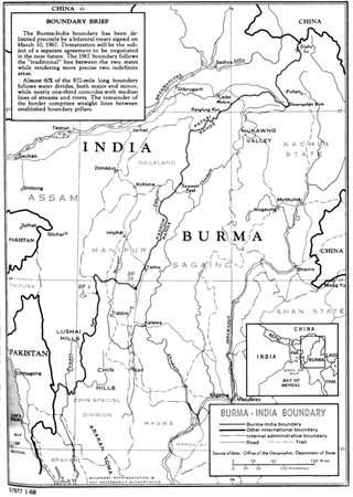
The India–Myanmar border is the international border between India and Myanmar. The border is 1,643 kilometres (1,021 mi) in length and runs from the tripoint with China in the north to the tripoint with Bangladesh in the south.