
Swansea is a coastal city and the second-largest city of Wales. It forms a principal area, officially known as the City and County of Swansea.

Swansea Bay is a bay on the southern coast of Wales. The River Neath, River Tawe, River Afan, River Kenfig and Clyne River flow into the bay. Swansea Bay and the upper reaches of the Bristol Channel experience a large tidal range. The shipping ports in Swansea Bay are Swansea Docks, Port Talbot Docks and Briton Ferry wharfs.

River Neath is a river in south Wales running south west from the point at which its headwaters arising in the Brecon Beacons National Park converge to its mouth at Baglan Bay below Briton Ferry on the east side of Swansea Bay.

The River Tawe is a 30 miles (48 km) long river in South Wales. Its headwaters flow initially east from its source below Llyn y Fan Fawr south of Moel Feity in the Black Mountains, the westernmost range of the Brecon Beacons National Park, before the river turns south and then southwest to its estuary at Swansea. Its main tributaries are the right bank Upper and Lower Clydach Rivers and the Afon Twrch. The total area of the catchment is some 246 km2 (95 sq mi). The Tawe passes through a number of towns and villages including Ystradgynlais, Ystalyfera, Pontardawe, and Clydach and meets the sea at Swansea Bay below Swansea. The Tawe Valley is more commonly known as the Swansea Valley.

The Neath and Tennant Canals are two independent but linked canals in South Wales that are usually regarded as a single canal. The Neath Canal was opened from Glynneath to Melincryddan, to the south of Neath, in 1795 and extended to Giant's Grave in 1799, in order to provide better shipping facilities. With several small later extensions it reached its final destination at Briton Ferry. No traffic figures are available, but it was successful, as dividends of 16 per cent were paid on the shares. The canal was 13.5 miles (21.7 km) long and included 19 locks.

St Thomas is a suburban district and community in Swansea, Wales. It is a mainly residential area which lies east of Swansea city centre across the River Tawe and falls within the St Thomas ward. Fabian Way divides the traditional residential area from Swansea Docks, which has been developed during the 2010s to create a new area of commercial activities and apartments.

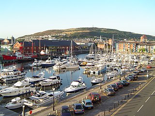
The Maritime Quarter is a residential area of Swansea, Wales, UK located immediately south of the city centre shopping core. It falls within Swansea's Castle ward. The area is bounded by Brynmill to the west, Swansea Bay to the South, the River Tawe to the east and the A4067 to the north.
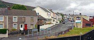
Port Tennant is a suburban district of Swansea, Wales, falling within the St. Thomas ward. Port Tennant lies at the southern foot of Kilvey Hill just east of St. Thomas and is bounded by the Fabian Way to the south. It is a mostly residential area and is the location of one of Swansea's largest public cemeteries - Danygraig Cemetery.
Kilvey Hill is a hill in the St. Thomas area of Swansea. It is193 metres (633 ft) high and is classed as a Sub Marilyn. The top of Kilvey Hill enjoys panoramic views of Swansea city centre, Swansea Docks, Swansea Bay, ad the Lower Swansea Valley. The historic name of the hill in Welsh is Y Bigwrn, with its summit known as Pen y Bigwrn. Currently, however, it is generally known as Mynydd Cilfái.
Swansea Docks is the collective name for several docks in Swansea, Wales. The Swansea docks are located immediately south-east of Swansea city centre. In the mid-19th century, the port was exporting 60% of the world's copper from factories situated in the Tawe Valley. The working docks area today is owned and operated by Associated British Ports as the Port of Swansea and the northern part around the Prince of Wales Dock is undergoing re-development into a new urban area branded the SA1 Swansea Waterfront.
Crymlyn Burrows is an area of land in Wales, UK to the east of Swansea city centre, and south of Crymlyn Bog. It is bounded by Jersey Marine Beach to the south and the River Neath to the east. The land west of Baldwin's Crescent falls within the City and County of Swansea and from Baldwin's Crescent eastwards falls within Neath Port Talbot.
National Cycle Network, Route 43 is part of the National Cycle Network and the Celtic Trail, which connects Swansea with Builth Wells. Most of the route is still awaiting development. As of June 2006, there is a 13-mile section out of Swansea that is open and signed.

St. Thomas is the name of an electoral ward of Swansea, Wales.

SA1 Swansea Waterfront is the marketing name given to the brownfield development area located in the northern part of Swansea Docks, Wales. The area is located directly to the southeast of Swansea city centre. It is bordered by the Fabian Way to the north and covers the Prince of Wales Dock area.
Swansea Beach stretches for five miles along Swansea Bay between the Maritime Quarter and the "Knab Rock" near Mumbles in Wales. It is backed by a promenade/cycle track and a coastal road. The southern section of the Swansea Bay beach between Blackpill and Mumbles is designated Site of Special Scientific Interest.

The Clyne River is a river in Swansea, south Wales. It has a total length of 6.5 miles (10.5 km), and flows through the Clyne Valley Country Park for much of its length.
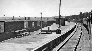
Swansea Bay is a former railway station in Swansea next to Swansea Bay, in South Wales, opened to passenger and goods traffic on 14 December 1867. Owned successively by the Llanelly Railway and Dock Company, the Swansea and Carmarthen Railways Company, the London and North Western Railway Company, the London, Midland and Scottish Railway Company and British Railways, it was served by trains to and from Shrewsbury, Crewe, Liverpool, Manchester and York and formed the southern terminus of the Central Wales line, most of which is still operational as the Heart of Wales Line. Swansea Bay closed in June 1964, having been listed in the Report on the Reshaping of British Railways the previous year. The former station is near 'The Slip' opposite the Bay View Public House. It was adjacent to the Swansea and Mumbles Railway which was closed in 1960, and opposite the Western end of St Helen's Road, which until the 1930s was the terminus of one of the Town tram lines. Much of the trackbed is now part of the A4067 road towards Swansea Victoria.
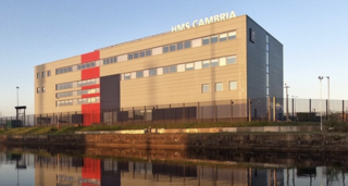
HMS Cambria is the lead Royal Naval Reserve unit in Wales. It is based in the docks of the Welsh capital, Cardiff.

Swansea East Dock railway station served the city of Swansea, in the historical county of Glamorganshire, Wales, from 1880 to 1936 on the Swansea and Neath Railway.
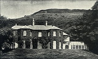
Maesteg House was a manor house built on the south slope of Kilvey Hill, Swansea. It was built in the mid 19th century by the copper and tin industrialist Pascoe St Leger Grenfell. The building is no longer there, as it was demolished shortly after the First World War to make way for new housing development.