Fairmount Township, New Jersey

Last updated

Fairmount was a township that existed in Essex County, New Jersey, United States, from 1862 to 1863.

A township, in the context of New Jersey local government, refers to one of five types and one of eleven forms of municipal government. As a political entity, a township in New Jersey is a full-fledged municipality, on par with any town, city, borough, or village. They collect property taxes and provide services such as maintaining roads, garbage collection, water, sewer, schools, police and fire protection. The Township form of local government is used by 27% of New Jersey municipalities; however, slightly over 50% of the state's population resides within them.

Essex County, New Jersey County in the United States

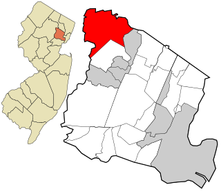
Essex County is a county in the northeastern part of the U.S. state of New Jersey. As of the 2017 Census estimate, the county's population was 808,285, making it the state's third-most populous county, an increase of 3.1% from the 2010 United States Census, when its population was enumerated at 783,969, in turn a decrease of 1.2% from the 793,633 enumerated in the 2000 Census. In 2010, the county dropped down to third-largest, behind Middlesex County, and was one of only two counties in the state to see a decline between 2000 and 2010. Its county seat is Newark, the most populous city in the state. It is part of the New York Metropolitan Area.

New Jersey State of the United States of America

New Jersey is a state in the Mid-Atlantic and Northeastern regions of the United States. It is located on a peninsula, bordered on the north and east by the state of New York, particularly along the extent of the length of New York City on its western edge; on the east, southeast, and south by the Atlantic Ocean; on the west by the Delaware River and Pennsylvania; and on the southwest by the Delaware Bay and Delaware. New Jersey is the fourth-smallest state by area but the 11th-most populous, with 9 million residents as of 2017, and the most densely populated of the 50 U.S. states; its biggest city is Newark. New Jersey lies completely within the combined statistical areas of New York City and Philadelphia. New Jersey was the second-wealthiest U.S. state by median household income as of 2017.

Fairmount was incorporated as a township by an Act of the New Jersey Legislature on March 11, 1862, from portions of Caldwell Township (now Fairfield Township), Livingston Township and Orange Township. [1]

New Jersey Legislature the legislature of the U.S. state of New Jersey

The New Jersey Legislature is the legislative branch of the government of the U.S. state of New Jersey. In its current form, as defined by the New Jersey Constitution of 1947, the Legislature consists of two houses: the General Assembly and the Senate. The Legislature meets in the New Jersey State House, in the state capital of Trenton. Democrats currently hold super majorities in both chambers of the legislature.

Fairfield Township, Essex County, New Jersey Township in New Jersey

Fairfield is a township in far northwestern Essex County, New Jersey, United States. As of the 2010 United States Census, the township's population was 7,466, reflecting an increase of 403 (+5.7%) from the 7,063 counted in the 2000 Census, which had in turn declined by 552 (-7.2%) from the 7,615 counted in the 1990 Census. Fairfield is the least densely populated town in Essex County.

Livingston, New Jersey Township in New Jersey, United States

Livingston is a township in Essex County, New Jersey, United States. As of the 2010 United States Census, the township's population was 29,366, reflecting an increase of 1,975 (+7.2%) from the 27,391 counted in the 2000 Census, which had in turn increased by 782 (+2.9%) from the 26,609 counted in the 1990 Census.

Fairmount lasted until April 10, 1863, shortly after its first anniversary, when it was absorbed into the newly created West Orange Township. [1] [2]

West Orange, New Jersey Township in New Jersey

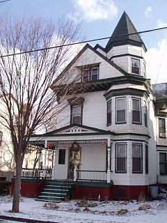
West Orange is a suburban township in central Essex County, New Jersey, United States. As of the 2010 United States Census, the township's population was 46,207, reflecting an increase of 1,264 (+2.8%) from the 44,943 counted in the 2000 Census, which had in turn increased by 5,840 (+14.9%) from the 39,103 counted in the 1990 Census.

Related Research Articles

Orange, New Jersey Township in New Jersey, United States

The City of Orange is a township in Essex County, New Jersey, United States. As of the 2010 United States Census, the township's population was 30,134, reflecting a decline of 2,734 (-8.3%) from the 32,868 counted in 2000, which had in turn increased by 2,943 (+9.8%) from the 29,925 counted in the 1990 Census.

Clinton Hill, Newark human settlement in United States of America

Clinton Hill is a neighborhood within the south-central portion of the city of Newark in Essex County, New Jersey, United States. It is centered at Clinton Avenue, and bounded roughly by Elizabeth Avenue in the east, Hawthorne Avenue in the south, Avon Avenue in the north, and Irvington in the west.

Fairmount, Newark, New Jersey human settlement in United States of America

Fairmount is an unincorporated community and neighborhood within the city of Newark in Essex County, New Jersey, United States. It is part of the West Ward. Its population is mostly African American, of varying economic statuses. Central Avenue is the major street, though its commerce is considerably reduced from the Industrial Era heyday. The neighborhood is officially bounded by South Orange Avenue on the south, the Garden State Parkway on the west, Interstate 280 on the north, and the University of Medicine and Dentistry of New Jersey on the east.

Fairmount Cemetery (Newark, New Jersey) cemetery in Newark, New Jersey

Fairmount Cemetery is a 150-acre (0.61 km2) Victorian cemetery in the West Ward of Newark, New Jersey, in the neighborhood of Fairmount. It opened in 1855, shortly after the Newark City Council banned burials in the central city due to fears that bodies spread yellow fever. The first burial in Fairmount Cemetery was a 24-year-old man named Lewis J. Pierson. Fairmount is still accepting interments.

The Oranges human settlement in United States of America

The Oranges are a group of four municipalities in Essex County, New Jersey, all of which have the word Orange in their name. All of these communities were named for William III of Orange, Stadtholder of the Dutch Republic, and from 1689 till 1712 King of England, Ireland, and Scotland. The four municipalities are the City of Orange Township, City of East Orange, Township of South Orange Village and Township of West Orange.

Amwell Township was a Township that existed in Hunterdon County, New Jersey, United States, from 1708 to 1846.

New Jerseys 11th congressional district

New Jersey's 11th Congressional District is a suburban district in northern New Jersey. The district includes portions of Essex, Morris, Passaic, and Sussex Counties; it is centered in Morris County. The district is one of the 10 most affluent congressional districts in the United States. As of February 2019, the typically Republican-leaning district is represented by Democrat Mikie Sherrill.

New Jerseys 10th congressional district

New Jersey's 10th congressional district is an urban congressional district in the U.S. state of New Jersey. The district consists of portions of Essex, Hudson and Union counties, and includes the cities of Newark and Orange.

The Edison Township Public Schools is a comprehensive community public school district, serving students in kindergarten through twelfth grade from Edison, in Middlesex County, New Jersey, United States. The school district has a preschool, 11 elementary schools, four middle schools and two high schools that are part of the district, serving a culturally diverse student population.

Palisades Township was a township that existed in Bergen County, New Jersey, United States. The township was in existence from 1871 to 1922.

Gillette station NJ Transit rail station

Gillette is the first of three station stops on the Gladstone Branch of the Morris & Essex Line of NJ Transit, in Long Hill Township, New Jersey. The station consists of a small low-level side platform with a covered bench shelter on the inbound side of the single track. The station is located at the intersection of Mountain Avenue and Jersey Avenue in the Gillette portion of Long Hill Township. The station has 82 parking spaces and bike lockers. The station serves trains that go to Gladstone, Summit, Hoboken Terminal and New York Pennsylvania Station for commuters.

Nottingham Township was a township that existed for almost 168 years in New Jersey, from 1688 until it was dissolved in 1856.

Clinton Township was a township located in Essex County, New Jersey, United States, which existed from 1834 to 1902.

Bergen was a city that existed in Hudson County, New Jersey, United States, from 1855 to 1870.

The New Jersey Republican State Committee (NJGOP) is the affiliate of the Republican Party in New Jersey. The Committee was founded in 1880. The party is currently led by Doug Steinhardt, who replaced Michael B. Lavery. Lavery replaced Sam Raia of Saddle River, New Jersey.

Van Vorst Park neighborhood in Jersey City, New Jersey

Van Vorst Park is an upper income neighborhood in the Historic Downtown of Jersey City, Hudson County, New Jersey, United States, centered on a park sharing the same name. The neighborhood is located west of Paulus Hook and Marin Boulevard, north of Grand Street, east of the Turnpike Extension, and south of The Village and Christopher Columbus Drive. Much of it is included in the Van Vorst Park Historical District.

Bergen-Lafayette is a section of Jersey City, New Jersey.

Fairmount Avenue station

Fairmount Avenue is a former New Jersey Transit rail station on the Pascack Valley Line. The station was one of three rail stations in Hackensack, New Jersey, United States, and was located at Fairmount Avenue and Temple Avenue. The Essex Street and Anderson Street stations are also located in Hackensack. The station house was built in 1870 as part of the extension railroad for the Hackensack and New York Railroad on a track extension from Anderson Street in Hackensack. The line became part of the Erie Railroad in 1896 and New Jersey Transit in 1983.

References

  1. 1 2 "The Story of New Jersey's Civil Boundaries: 1606-1968", John P. Snyder, Bureau of Geology and Topography; Trenton, New Jersey; 1969. p. 127.
  2. West Orange article, Encyclopædia Britannica Eleventh Edition, accessed March 9, 2007


Coordinates: 40°47′53″N74°17′06″W / 40.798°N 74.285°W / 40.798; -74.285

Geographic coordinate system Coordinate system

A geographic coordinate system is a coordinate system that enables every location on Earth to be specified by a set of numbers, letters or symbols. The coordinates are often chosen such that one of the numbers represents a vertical position and two or three of the numbers represent a horizontal position; alternatively, a geographic position may be expressed in a combined three-dimensional Cartesian vector. A common choice of coordinates is latitude, longitude and elevation. To specify a location on a plane requires a map projection.