
Boca Raton is a city in Palm Beach County, Florida, United States. The population was 97,422 in the 2020 census and it ranked as the 23rd-largest city in Florida in 2022. However, many people with a Boca Raton postal address live outside of municipal boundaries, such as in West Boca Raton. As a business center, the city also experiences significant daytime population increases. A part of South Florida, Boca Raton is 45 miles (72 km) north of Miami and is a principal city of the Miami metropolitan area, which had a population of 6,012,331 as of 2015.

Boynton Beach is a city in Palm Beach County, Florida, United States. It is situated about 57 miles (92 km) north of Miami. The 2020 census recorded a population of 80,380. Boynton Beach is a principal city of the Miami metropolitan area, which was home to 6,138,333 people at the 2020 census. The city is named after Nathan Boynton, a Civil War major and Michigan politician who became one of the first settlers in the area in 1895. Boynton Beach is located north of Delray Beach, south of Hypoluxo and Lantana, and east of Golf, while the municipalities of Briny Breezes, Gulf Stream, Manalapan, and Ocean Ridge are situated to the east across the Intracoastal Waterway.

Lake Worth Beach, previously named Lake Worth, is a city in east-central Palm Beach County, Florida, United States, located about 64 miles (103 km) north of Miami. The city's name is derived from the body of water along its eastern border known as the Lake Worth Lagoon, which was named for General William J. Worth, who led United States Army forces during the last part of the Second Seminole War. Lake Worth Beach is situated south of West Palm Beach, southeast of Lake Clarke Shores, east of Palm Springs, and north of Lantana, while a small section of the city also partitions the town of Palm Beach. The 2010 census recorded a population of 34,910, which increased to 42,219 in the 2020 census. Lake Worth Beach is within the Miami metropolitan area, which was home to an estimated 6,138,333 people in 2020.

Palm Beach is an incorporated town in Palm Beach County, Florida, United States. Located on a barrier island in east-central Palm Beach County, the town is separated from West Palm Beach and Lake Worth Beach by the Intracoastal Waterway to its west and a small section of the Intracoastal Waterway and South Palm Beach to its south. It is part of the South Florida metropolitan area. As of the 2020 census, Palm Beach had a year-round population of 9,245.

West Palm Beach is a city in and the county seat of Palm Beach County, Florida, United States. It is located immediately to the west of the adjacent Palm Beach, which is situated on a barrier island across the Lake Worth Lagoon.

South Beach, also nicknamed colloquially as SoBe, is a neighborhood in Miami Beach, Florida. It is located east of Miami between Biscayne Bay and the Atlantic Ocean. The area encompasses Miami Beach south of Dade Boulevard.
The Millionaires' Mile, Millionaires' Row, Billionaires Row, Golden Mile or Alpha Street are the exclusive residential neighborhoods of various cities, often along one scenic strip such as a riverside or hilltop drive, or a wide city boulevard.

The Hampton Terrace Historic District, originally called the Lakewood Manor Subdivision, is a U.S. historic district located in the Old Seminole Heights neighborhood of Tampa, Florida. The district is roughly bounded by Hanna Avenue to the north, 15th Street to the east, Nebraska Avenue to the west, and Hillsborough Avenue to the south. Hampton Terrace Historic District was so designated by its inclusion in the National Register of Historic Places on January 27, 1999.
The Grandview Heights Historic District is a U.S. historic district located in West Palm Beach, Florida. The district is bounded by Park Place, Alabama Avenue, M Street, and Lake Avenue.
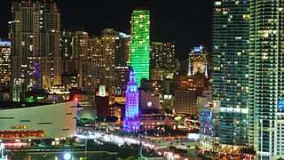
Brickell is a neighborhood in Miami, Florida located directly east of Interstate 95, south of the historic CBD, and north of Coconut Grove. Brickell is known as the financial district of Miami, as well as South Florida.

There are more than 500 neighborhoods within the area of Jacksonville, Florida, the largest city in the contiguous United States by area. These include Downtown Jacksonville and surrounding neighborhoods. Additionally, greater Jacksonville is traditionally divided into several major sections with amorphous boundaries: Northside, Westside, Southside, and Arlington, as well as the Jacksonville Beaches.

The Kenwood Historic District is a district located in St. Petersburg, Florida U.S.A. It was designated on August 4, 2003, and is located immediately west of downtown, bounded by 9th Avenue North, 1st Avenue North, 19th Street North and 34th Street North. It contains 2,203 historic buildings. The Grand Central adjoins the district at its southern boundary.
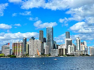
Downtown Miami is the urban city center of Miami, Florida. The city's greater downtown region consists of the Central Business District, Brickell, the Historic District, Government Center, the Arts & Entertainment District, and Park West. It is divided by the Miami River and is bordered by Midtown Miami's Edgewater and Wynwood sections to its north, Biscayne Bay to its east, the Health District and Overtown to its west, and Coconut Grove to its south.

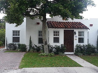
The Clifton Rice House is a historic house located at 714 Claremore Drive in West Palm Beach, Florida.
South Nebraska is a neighborhood within the city limits of Tampa, Florida. As of the 2000 census the neighborhood had a population of 2,908. The ZIP codes of the neighborhood are 33602 and 33605.

The Upper Eastside is a neighborhood in Miami, Florida. It is north of Edgewater, east of Little Haiti, south of the village of Miami Shores, and sits on Biscayne Bay. In geographical order from south to north and east to west, it contains the subdivisions of Magnolia Park, Bay Point, Morningside, Bayside, Belle Meade, Shorecrest, and Palm Grove. The MiMo District along Biscayne Boulevard in the area is host to many art galleries, shops and restaurants.
Harvey and Clarke was an American architectural firm formed by Henry Stephen Harvey and L. Philips Clarke in West Palm Beach, Florida, in 1921. The firm was active in South Florida for only a few years, but in that time designed a number of distinctive homes, apartments, churches, and commercial buildings. Harvey was a member of the West Palm Beach Planning Commission. Firm member Gustav Maass designed several railroad stations, and became a noted South Florida architect in his own right.

Riverside and Avondale are two adjacent and closely associated neighborhoods, alternatively considered one continuous neighborhood, of Jacksonville, Florida. The area is primarily residential, but includes some commercial districts, including Five Points, the King Street District, and the Shoppes of Avondale.


