The Forestry Commission is a non-ministerial government department responsible for the management of publicly owned forests and the regulation of both public and private forestry in England. It was formerly also responsible for Forestry in Wales and Scotland, however on 1 April 2013, Forestry Commission Wales merged with other agencies to become Natural Resources Wales, whilst two new bodies were established in Scotland on 1 April 2019.

Ae is a village in Dumfries and Galloway, south west Scotland. The village is located on the edge of a 15,000-acre (61 km2) man-made conifer forest, and is approximately 9 miles (14 km) north of Dumfries.

The Southern Uplands are the southernmost and least populous of mainland Scotland's three major geographic areas. The term is used both to describe the geographical region and to collectively denote the various ranges of hills and mountains within this region. An overwhelmingly rural and agricultural region, the Southern Uplands are partly forested and contain many areas of open moorland - the hill names in the area are congruent with these characteristics.
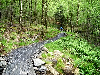
A grading system for way-marked off-road cycling trails has been adopted in the UK, and is used by official bodies such as Forestry England and IMBA-UK. It was originally developed by Cyclists' Touring Club (CTC) employee Colin Palmer in June 1999, based on a system widely used for grading cross-country skiing routes.

Parbat District (Nepali: पर्वत जिल्ला[pʌɾbʌt], is a hilly area of Nepal. It is a part of Gandaki Province and one of the seventy-seven districts of Nepal. The district, with Kusma as its district headquarters, covers an area of 494 km2 and has a population of 157,826. It is the fourth smallest district of Nepal with 47 VDCs currently. It is mainly known for the Gupteshwar Cave, which is visited by thousands of pilgrims during Shivaratri. Patheshwari Temple a notable temple in Kushma located at Katuwa Chaupari of Kushma-09. Patheshwori Mandir has many sub-temples inside like Ram Janaki Mandir, Bhagwati, Devi, Hanuman, and others. Alapeshwar cave is a cave in this district. It is also noted for the Dahere Deurali Temple, which is visited by thousands of pilgrims during Balachaturdanshai. Kamadhenu Mandir is another temple of Parbat district which is located in Khurkot development committee. Recently the Modi hydro project of 10 M.W. has been constructed in this district. Parbat's biggest playground lies in Phalewas village named Majhi Chour and Indra Chour.
Glentress Forest is located near Peebles in the Scottish Borders, about 30 miles south of Edinburgh. Part of the Tweed Valley Forest Park along with Traquair Forest in Innerleithen, it is the home of a mountain biking centre which is one of the 7stanes mountain bike trails operated throughout southern Scotland by Forestry and Land Scotland.

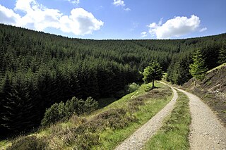
The 7stanes are seven mountain biking centres spanning the south of Scotland, from the heart of the Scottish Borders to Dumfries and Galloway. They are all in Forestry and Land Scotland forests and are known as the 7stanes because each venue features a 'stane', created by artist Gordon Young, somewhere along the forest trails.

Raft Cove Provincial Park is a provincial park in British Columbia, Canada, located south of San Josef Bay on northwestern Vancouver Island.

Galloway Forest Park is a forest park operated by Forestry and Land Scotland, principally covering woodland in Dumfries and Galloway. It is claimed to be the largest forest in the UK. The park was granted Dark Sky Park status in November 2009, being the first area in the UK to be so designated.

Glenariff Forest Park is an 1185 hectare forest in County Antrim, Northern Ireland. It is part of Glenariff glen itself. The forest is managed by the Northern Ireland Forest Service, the state body responsible for forestry in the province, which is part of the Department of Agriculture, Environment and Rural Affairs.
The Lytton First Nation, a First Nations band government, has its headquarters at Lytton in the Fraser Canyon region of the Canadian province of British Columbia. While it is the largest of all Nlaka'pamux bands, unlike all other governments of the Nlaka'pamux (Thompson) people, it is not a member of any of the three Nlaka'pamux tribal councils, which are the Nicola Tribal Association, the Fraser Canyon Indian Administration and the Nlaka'pamux Nation Tribal Council.

Canoe, British Columbia, is a semi-rural community in British Columbia within the larger City of Salmon Arm. The community lies on the south side of Shuswap Lake, northeast of the city centre, just off the Trans Canada Highway. Canoe is home to the Canoe Forest Products plywood plant, which processes lumber from the surrounding forests for sale and export.
Glentrool is a collection of mountain biking routes through the heart of Galloway in southwest Scotland. The mountain bike routes are part of the 7Stanes project by Forestry and Land Scotland throughout the Scottish Borders and Dumfries and Galloway.
Mabie is a collection of mountain biking routes located in Dumfries and Galloway, southwest Scotland. The mountain bike routes are part of the 7Stanes project by Forestry and Land Scotland throughout the Scottish Borders and Dumfries and Galloway.
Culbin Sands, Forest and Findhorn Bay is a huge area of coast and countryside and an SSSI in Moray, Scotland, stretching from just east of the town of Nairn eastwards to the village of Findhorn and its bay. All of the areas are very important for wildlife in general and are strongly protected by law. The Culbin Sands are known in Gaelic as Bar Inbhir Èireann.

The Cross River National Park is a national park of Nigeria, located in Cross River State, Nigeria. There are two separate sections, Okwangwo and Oban . The park has a total area of about 4,000 km2, most of which consists of primary moist tropical rainforests in the North and Central parts, with mangrove swamps on the coastal zones. Parts of the park belong to the Guinea-Congolian region, with a closed canopy and scattered emergent trees reaching 40 or 50 meters in height.

Scotland is ideal for tree growth, thanks to its mild winters, plentiful rainfall, fertile soil and hill-sheltered topography. As of 2019 about 18.5% of the country was wooded. Although this figure is well below the European Union (EU) average of 43%, it represents a significant increase compared to the figure of 100 years previously: in 1919 it was estimated that only 5% of the country's total land area was covered in forest. The Scottish Government's Draft Climate Change Plan has set an aim of increasing coverage to 21% of Scotland by 2032, with the rate of afforestation rising to 15,000 hectares per year by 2024.

Forestry and Land Scotland (FLS) is responsible for managing and promoting Scotland's national forest estate: land, predominantly covered in forest, owned by the Scottish Government on behalf of the nation. It was formed on 1 April 2019, to take over some of the responsibilities of Forestry Commission Scotland, which was dissolved. The organisation exists alongside Scottish Forestry, also established on 1 April 2019, which is responsible for regulation, policy and support to landowners. Forestry and Land Scotland's key functions are to look after the national forest estate, including unforested land within this portfolio, and to produce and supply timber. Within this remit they are expected to enhance biodiversity, increase public access to the outdoors, encourage tourism and support the rural economy.
Tweed Valley Forest Park is forest park in the border region of Scotland. It consists of a network of eight forests managed by Forestry and Land Scotland (FLS) spread along the valley of the River Tweed, and which are managed with an emphasis on recreational facilities for visitors.
Kirroughtree Forest is located near Newton Stewart in Dumfries and Galloway, southwest Scotland and overlooks the Irish Sea. It is managed by Forestry and Land Scotland and is part of the Galloway Forest Park. It has been developed as a centre for mountain biking trails.
