
Cheshire is a county in North West England, bordering Merseyside and Greater Manchester to the north, Derbyshire to the east, Staffordshire and Shropshire to the south, and Flintshire and Wrexham County Borough in Wales to the west. Cheshire's county town is the City of Chester (118,200); the largest town is Warrington (209,700). Other major towns include Crewe (71,722), Ellesmere Port (55,715), Macclesfield (52,044), Runcorn (61,789), Widnes (61,464) and Winsford (32,610), Northwich (19,924)

Mercia was one of the kingdoms of the Anglo-Saxon Heptarchy. The name is a Latinisation of the Old English Mierce or Myrce, meaning "border people". Mercia dominated what would later become England for three centuries, subsequently going into a gradual decline while Wessex eventually conquered and united all the kingdoms into the Kingdom of England.

Shropshire is a county in England, bordering Wales to the west, Cheshire to the north, Staffordshire to the east, and Worcestershire and Herefordshire to the south. Shropshire Council was created in 2009, a unitary authority taking over from the previous county council and five district councils. The borough of Telford and Wrekin has been a separate unitary authority since 1998 but continues to be included in the ceremonial county.

Staffordshire is a landlocked county in the West Midlands of England. It borders Cheshire to the northwest, Derbyshire and Leicestershire to the east, Warwickshire to the southeast, West Midlands and Worcestershire to the south, and Shropshire to the west.
South Shropshire was, between 1974 and 2009, a local government district in south west Shropshire, England.

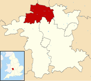
Telford and Wrekin is a unitary district with borough status in the West Midlands region of England. The district was created in 1974 as The Wrekin, then a non-metropolitan district of Shropshire. In 1998 the district became a unitary authority and was renamed Telford and Wrekin. It remains part of the Shropshire ceremonial county and shares institutions such as the Fire and Rescue Service and Community Health with the rest of Shropshire.

East Staffordshire is a local government district with borough status in Staffordshire in England. It has two main towns: Burton upon Trent and Uttoxeter.

South Staffordshire is a local government district in Staffordshire, England. The district lies to the north and west of the West Midlands county, bordering Shropshire to the west and Worcestershire to the south. It contains no towns of major size, and many of the settlements within the district are considered dormitory villages for Stafford, Telford, and the West Midlands conurbation.
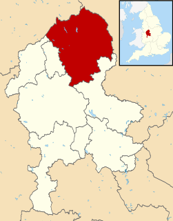
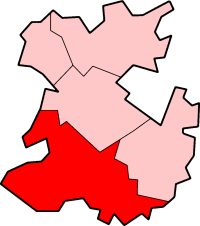
Staffordshire Moorlands is a local government district in Staffordshire, England. Its council, Staffordshire Moorlands District Council, is based in Leek and is located between the city of Stoke-on-Trent and the Peak District National Park. The 2001 census recorded the population as 94,489.
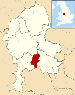
Cannock Chase is a local government district in Staffordshire, England. Its council is based in the town of Cannock; other notable towns are Rugeley and Hednesford. The district covers a large part of the Cannock Chase Area of Outstanding Natural Beauty, from which it takes its name.

The Borough of Wellingborough is a Non-metropolitan district and borough in Northamptonshire, England. It is named after Wellingborough, its main town, but also includes surrounding rural areas.

Bromsgrove is a local government district in Worcestershire, England. Its council is based in the town of Bromsgrove.
The Metropolitan Borough of Solihull is a metropolitan borough of the West Midlands, in west-central England. It is named after its largest town, Solihull, from which Solihull Metropolitan Borough Council is based. For Eurostat purposes it is a NUTS 3 region and is one of seven boroughs or unitary districts that comprise the "West Midlands" NUTS 2 region. Much of the large residential population in the north of the borough centres on the communities of Castle Bromwich, Chelmsley Wood, Fordbridge, Kingshurst, Marston Green and Smith's Wood. In the south are the towns of Solihull and Shirley.

Arden is an area, located mainly in Warwickshire, England, and also part of Staffordshire and Worcestershire traditionally regarded as extending from the River Avon to the River Tame. It was once heavily wooded, giving rise to the name 'Forest of Arden'. It does not seem that the area was subject to forest law, however.

The North Wessex Downs Area of Outstanding Natural Beauty (AONB) is located in the English counties of Berkshire, Hampshire, Oxfordshire and Wiltshire. The name North Wessex Downs is not a traditional one, the area covered being better known by various overlapping local names, including the Berkshire Downs, the North Hampshire Downs, the White Horse Hills, the Lambourn Downs, the Marlborough Downs, the Vale of Pewsey and Savernake Forest.

Penn is an area now divided between the City of Wolverhampton and South Staffordshire district. The population of the Wolverhampton Ward taken at the 2011 census was 12,718. Originally, it was a village in the historic county of Staffordshire. There is considerable confusion about exactly which areas fall within Penn. In 19th century censuses, Merry Hill, Bradmore are understood to form part of Penn, although these areas are generally understood to be separate today. However, there has never been any doubt that the two historic settlements of Upper and Lower Penn form the core of the area.
Wyre Forest is a local government district in Worcestershire, England, covering the towns of Kidderminster, Stourport-on-Severn and Bewdley, and several civil parishes and their villages. Its council was previously based in Stourport-on-Severn, but moved to new purpose built offices on the outskirts of Kidderminster in 2012.

Lichfield District Council is a non metropolitan district council, which covers the district of Lichfield in Staffordshire, England. It was formed in 1974 from Lichfield City Council and Lichfield Rural District Council. The council offices are located at the District Council House on Frog Lane, in the centre of Lichfield.

The Mercian Trail is the name given to a group of museums and historical sites in the West Midlands of England that will be used to display objects from the Staffordshire Hoard. The trail is organised by a partnership of Lichfield District, Tamworth Borough Council, Staffordshire County Council, Stoke-on-Trent City Council and Birmingham City Council, and features the following locations:

The boundaries of Worcestershire, England have been fluid for over 150 years since the first major changes in 1844. There were many detached parts of Worcestershire in the surrounding counties, and conversely there were islands of other counties within Worcestershire. The 1844 Counties Act began the processing of eliminating these, but the process was not completed until 1966, when Dudley was absorbed into Staffordshire.
