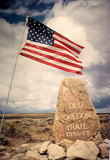
The Oregon Trail is a 2,170-mile (3,490 km) historic East–West, large-wheeled wagon route and emigrant trail in the United States that connected the Missouri River to valleys in Oregon. The eastern part of the Oregon Trail spanned part of the future state of Kansas, and nearly all of what are now the states of Nebraska and Wyoming. The western half of the trail spanned most of the future states of Idaho and Oregon.

Miner County is a county in the U.S. state of South Dakota. As of the 2010 United States Census, the population was 2,389. Its county seat is Howard. The county was created in 1873 and organized in 1880.

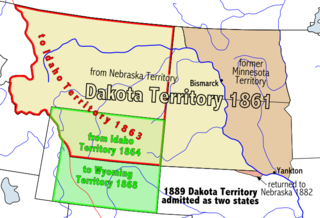
The Territory of Nebraska was an organized incorporated territory of the United States that existed from May 30, 1854, until March 1, 1867, when the final extent of the territory was admitted to the Union as the State of Nebraska. The Nebraska Territory was created by the Kansas–Nebraska Act of 1854. The territorial capital was Omaha. The territory encompassed areas of what is today Nebraska, Wyoming, South Dakota, North Dakota, Colorado, and Montana.

The Mormon Trail is the 1,300-mile (2,092 km) route that members of The Church of Jesus Christ of Latter-day Saints traveled from 1846 to 1868. Today, the Mormon Trail is a part of the United States National Trails System, known as the Mormon Pioneer National Historic Trail.

The California Trail was an emigrant trail of about 3,000 mi (4,800 km) across the western half of the North American continent from Missouri River towns to what is now the state of California. After it was established, the first half of the California Trail followed the same corridor of networked river valley trails as the Oregon Trail and the Mormon Trail, namely the valleys of the Platte, North Platte and Sweetwater rivers to Wyoming. In the present states of Wyoming, Idaho, and Utah, the California and Oregon trails split into several different trails or cutoffs.
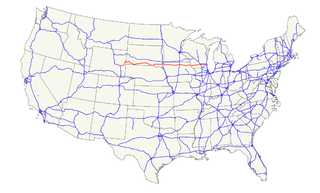
U.S. Route 18 is an east–west U.S. highway in the Midwestern United States. The western terminus is in Orin, Wyoming at an interchange with Interstate 25. Its eastern terminus is in downtown Milwaukee, Wisconsin. However, US 18 runs concurrent with other U.S. routes from its western terminus to Mule Creek Junction, Wyoming.

Fort Kearny was a historic outpost of the United States Army founded in 1848 in the western U.S. during the middle and late 19th century. The fort was named after Col. and later General Stephen Watts Kearny. The outpost was located along the Oregon Trail near Kearney, Nebraska. The town of Kearney took its name from the fort. The "e" was added to Kearny by postmen who consistently misspelled the town name. A portion of the original site is preserved as Fort Kearny State Historical Park by the Nebraska Game and Parks Commission.
Mullan Road was the first wagon road to cross the Rocky Mountains to the Inland of the Pacific Northwest. It was built by U.S. Army troops under the command of Lt. John Mullan, between the spring of 1859 and summer 1860. It led from Fort Benton, which at the time was in the Dakota Territory, then Idaho Territory from July 1863, and Montana Territory beginning in May 1864, and the navigational head of the Missouri River. The road connected to Fort Walla Walla, Washington Territory, near the Columbia River. The road previewed the route approximately followed of modern-day Interstate 15 and Interstate 90 through present-day Montana, Idaho, and Washington.
U.S. Highway 20 is a part of the United States Numbered Highway System that runs for 3,365 miles (5,415 km) from Newport, Oregon to Boston, Massachusetts. Within the State of Nebraska it is a state highway that begins on the Wyoming–Nebraska state line west of Harrison near the Niobrara River and runs to the Nebraska–Iowa state line in South Sioux City. Throughout its 431.60-mile (694.59 km) length the route passes through a diverse range of landscapes including bluffs and escarpments in the Northwest Panhandle, the Nebraska Sandhills in the northern part of the state, and rolling hills and plains as the highway approaches the Missouri River valley south of Sioux City, Iowa. Throughout its length, US 20 is a two-lane highway with the exception of the easternmost 8.45 miles (13.60 km) which is four-lane divided highway, the last 3.21 miles (5.17 km) of which is concurrent with Interstate 129. The 197 miles (317 km) between the Wyoming border and Valentine is designated as the Bridges to Buttes Byway, one of nine scenic byways in the state of Nebraska.
The history of South Dakota describes the history of the U.S. state of South Dakota over the course of several millennia, from its first inhabitants to the recent issues facing the state.

The path followed by the Oregon Trail, California Trail and Mormon Trail spans 400 miles (640 km) through the U.S. state of Wyoming. The trail entered from Nebraska on the eastern border of the state near the present day town of Torrington and exited on the western border near the towns of Cokeville and Afton. An estimated 350,000 to 400,000 settlers traveled on the trail through Wyoming between 1841 and 1868. All three trails follow the same path through most of the state. The Mormon Trail splits at Fort Bridger and enters Utah, while the Oregon and California Trails continue to Idaho.
U.S. Highway 75 is a part of the United States Numbered Highway System that runs for 1,239 miles (1,994 km) from Dallas, Texas to Kittson County, Minnesota where it ends just short of the Canada–United States border. Within the State of Nebraska it is a state highway that enters Nebraska on the Kansas state line about 9 miles (14 km) south of Dawson and travels north across the extreme eastern portion of the state, to the Nebraska–Iowa border in South Sioux City where it crosses the Missouri River along a concurrency with Interstate 129. The northern 210 miles (340 km) of the route generally travels parallel to the Missouri River. The 87.32-mile (140.53 km) section between the I-680 interchange in Omaha and the Interstate 129 interchange is designated the Lewis & Clark Scenic Byway, one of nine scenic byways in the state.

The Nobles Emigrant Trail, also known as the Fort Kearney, South Pass and Honey Lake Wagon Road, is a trail in California that was used by emigrant parties from the east as a shortened route to northern California. It was pioneered in 1851 by William Nobles, who discovered an easy shortcut between the Applegate Trail in Nevada and the Lassen Trail in California. The trail was extensively used until the 1870s, when it was superseded by railroads.

U.S. Highway 136 is a part of the United States Numbered Highway System that runs for 804 miles (1,294 km) between Edison, Nebraska and Speedway, Indiana. It is a spur route of US 36 despite never intersecting its parent. Within the State of Nebraska it is a state highway that begins at a junction with US 6 and US 34 north of Edison and travels east across the southern part of the state to the Nebraska–Missouri state line in Brownville along the banks of the Missouri River. Throughout its 239.88-mile (386.05 km) length, the highway is known as the Heritage Highway, one of nine scenic byways in the state. The highway travels across the grassland prairies of southern Nebraska to the woods of the Missouri River Valley encountering winding rivers, farmlands, and historic settlements. These landscapes were featured in stories from Pulitzer Prize-winning author Willa Cather recounting life on the Nebraska Plains during the end of the 19th century. For its entire length, US 136 is a two-lane highway with the exception of a 0.51-mile (0.82 km) stretch of divided highway within Fairbury.
The Overland Trail was a stagecoach and wagon trail in the American West during the 19th century. While portions of the route had been used by explorers and trappers since the 1820s, the Overland Trail was most heavily used in the 1860s as an alternative route to the Oregon, California, and Mormon trails through central Wyoming. The Overland Trail was famously used by the Overland Stage Company owned by Ben Holladay to run mail and passengers to Salt Lake City, Utah, via stagecoaches in the early 1860s. Starting from Atchison, Kansas, the trail descended into Colorado before looping back up to southern Wyoming and rejoining the Oregon Trail at Fort Bridger. The stage line operated until 1869 when the completion of the First Transcontinental Railroad eliminated the need for mail service via Thais' stagecoach.
In the American Old West, overland trails were popular means of travel used by pioneers and immigrants throughout the 19th century and especially between 1830 and 1870 as an alternative to sea and railroad transport. These immigrants began to settle various regions of North America west of the Great Plains as part of the mass overland migrations of the mid-19th century. Settlers emigrating from the eastern United States were spurred by various motives, among them religious persecution, economic incentives, some people say that the interior to destinations in the far west, including the Oregon Trail, California Trail, and Mormon Trail. After the end of the Mexican–American War in 1849, vast new American conquests again enticed mass immigration. Legislation like the Donation Land Claim Act and significant events like the California Gold Rush further lured people to travel overland to the west.
The Oregon Trail is a historic 2,000-mile (3,264-km) trail used by American pioneers living in the Great Plains in the 19th century. The emigrants traveled by wagon in search of fertile land in Oregon's Willamette Valley.
The historic 2,170-mile (3,490 km) Oregon Trail connected various towns along the Missouri River to Oregon's Willamette Valley. It was used during the 19th century by Great Plains pioneers who were seeking fertile land in the West and North.
The Department of the Northwest was an Army Department created September 6, 1862 by the Union Army to put down the Sioux uprising in Minnesota. It was composed of the forces within the territory of the states of Wisconsin, Minnesota and Iowa, and the Nebraska and Dakota Territories . Nebraska Territory was detached to the Department of the Missouri on Oct. 11 1862.
U.S. Route 385 (US 385) is a part of the United States Numbered Highway System that travels from Big Bend National Park in Texas to US 85 in Deadwood, South Dakota. Within the state of Nebraska, the highway is known as the Gold Rush Byway, one of nine scenic byways across the state. The highway follows along the old Sidney-Black Hills trail which played a crucial role during the Black Hills Gold Rush in the late 1870s. It served as the primary route to transport gold and mining gear between Sidney, Nebraska and the Black Hills to the north. Today, the highway enters Nebraska in the southeastern portion of the Nebraska Panhandle on the state line with Colorado northeast of Julesburg and continues in a northerly direction to the South Dakota state line north of Chadron.