Freeman's Common

Last updated

Freeman's Common
Freeman's Common
TypeOpen space
Location Ravensden, Bedford
Coordinates 52°10′03″N0°27′07″W / 52.16738°N 0.45208°W / 52.16738; -0.45208 52°10′03″N0°27′07″W / 52.16738°N 0.45208°W / 52.16738; -0.45208
Area12.5ha
Created1858 [1]
Operated by Bedford Borough Council
OpenAll year
StatusOpen

Freeman's Common is a 12.5 hectare [2] area of land situated to the north of Bedford, in the parish of Ravensden. It was created in 1858. Over many years it has been the focus of local dispute as to whether the site should be developed. Despite the name, it is not in fact registered as common land. [3]

Contents

History

On 12 June 1797, an inclosure award created the Bedford Freeman's Common charity, following a 1795 Act of Parliament (35 Geo. 3. c. 87) which covered "Parishes of St. Paul, St. Peter and St. Cuthbert, Bedford". [4] This charity held land which in 1858 was sold to the Midland Railway to build Bedford railway station. A new Freeman's Common was purchased near Ravensden to replace the original. [1] [5]

In 1867 Freemen's Common formed part of the course for the Grand National Hunt Steeplechases, which ran from close to Clapham Wood across to Kimbolton Road. The Prince of Wales (later Edward VII) attended the steeplechases on the second day, arriving in Bedford via the Midlands Railway. [6] It also formed part of the 1868 course, although the race was less successful in its second year at Bedford, and was subsequently moved elsewhere. [7]

In 1871 it was suggested to build a smallpox hospital on the Freeman's Common at Cleat Hill. [8]

As of 1928 only four Freemen of Bedford remained with rights to graze animals on the Common. [9]

On 22 September 1970 the original charity was merged with the Bedford Freeman's Trust Fund, and combined charity was registered as the Bedford Freeman's Common Charity. [1]

In 2008 the site was proposed for development in the draft Local Plan, before the trustees had been consulted as to whether the site should be developed. [10] [11] [12]

In 2016 the site was added to Bedford Borough Council's draft Local Plan 2035, but in February 2017 was withdrawn following a decision of the Executive Committee, based on a previous view expressed by a government planning inspector when considering the development of Woodlands Park. [13] [2]

In 2018 the Freeman's Common charity was merged with the House of Industry Estate – the trustees of both charities were the members of the General Purposes Committee of Bedford Borough Council. [14] [15]

In January 2022 a Deed of Easement was made for conduit of services across Freemen's Common, and proceeds of £110,000 were recorded in the House of Industry Estate accounts. [16]

Archaeology

An archaeological study in 2003 found no archaeological features of interest. [17]

Related Research Articles

<span class="mw-page-title-main">Bedfordshire</span> County of England

Bedfordshire is a ceremonial and historic county in the East of England. It is bordered by Northamptonshire to the north, Cambridgeshire to the north-east and east, Hertfordshire to the south and south-east, and Buckinghamshire to the west. Since Bedfordshire County Council was abolished in 2009, the county has been administered by the three unitary authorities of the Borough of Bedford, Borough of Luton, and Central Bedfordshire.

<span class="mw-page-title-main">Bedford</span> Town in Bedfordshire, England

Bedford is a market town and unparished area in Bedfordshire, England. At the 2011 Census, the population of the Bedford built-up area was 106,940, making it the second-largest settlement in Bedfordshire, behind Luton, whilst the Borough of Bedford had a population of 157,479. Bedford is also the historic county town of Bedfordshire.

<span class="mw-page-title-main">Kempston</span> Human settlement in England

Kempston is a town and civil parish in the Borough of Bedford, Bedfordshire, England, situated around 2 miles (3.2 km) south-west of Bedford town centre. It had a population of 19,330 in the 2011 census, and forms part of the wider Bedford built-up area. The River Great Ouse separates it from the Queen's Park area of Bedford.

<span class="mw-page-title-main">Little Barford</span> Human settlement in England

Little Barford is a hamlet and civil parish in the Borough of Bedford in Bedfordshire, England about 7 miles (11 km) northeast of the county town of Bedford.

<span class="mw-page-title-main">Borough of Bedford</span> Unitary authority area in Bedfordshire, England

The Borough of Bedford is a unitary authority area with borough status in the ceremonial county of Bedfordshire, England. Its council is based in Bedford, its namesake and principal settlement, which is the county town of Bedfordshire. The borough contains one large urban area, the 71st largest in the United Kingdom that comprises Bedford and the adjacent town of Kempston, surrounded by a rural area with many villages. 75% of the borough's population live in the Bedford Urban Area and the five large villages which surround it, which makes up slightly less than 6% of the total land area of the Borough.

<span class="mw-page-title-main">Broom, Bedfordshire</span> Human settlement in England

Broom is a small village in the Central Bedfordshire district of the county of Bedfordshire, England about 8.5 miles (14 km) south-east of the county town of Bedford.

<span class="mw-page-title-main">Brickhill</span> Human settlement in England

Brickhill is a civil parish and electoral ward within northern Bedford in Bedfordshire, England.

<span class="mw-page-title-main">Heath and Reach</span> Human settlement in England

Heath and Reach is a village and civil parish near the Chiltern Hills in Bedfordshire, England. It is 2 miles (3.2 km) north of Leighton Buzzard and 3 miles (4.8 km) south of Woburn and adjoins the county boundary with Buckinghamshire. Nearby places are Leighton-Linslade, Great Brickhill and the Duke of Bedford's Woburn Abbey, Woburn Safari Park and Woburn Golf Club.

<span class="mw-page-title-main">Colmworth</span> Human settlement in England

Colmworth is a village and civil parish in the Borough of Bedford in the county of Bedfordshire, England about 6.5 miles (10 km) north-east of Bedford.

<span class="mw-page-title-main">Langford, Bedfordshire</span> Human settlement in England

Langford is a village and civil parish in the Central Bedfordshire district of the county of Bedfordshire, England about 10 miles (16 km) south-east of the county town of Bedford. The 2011 census gives the population as 3,091.

Luton is a large town located in the south of Bedfordshire, England.

<span class="mw-page-title-main">Wixams</span> Human settlement in England

Wixams is a new town and civil parish located in Bedfordshire, England, which has been under construction since early 2007. It is expected to become the third largest settlement in the Borough of Bedford after Bedford itself and Kempston, and one of the largest new settlements founded in England since the British new towns movement of the first twenty five years after World War II. Part of the site is also in Central Bedfordshire. At the 2011 Census the population of the new town was included in the civil parish of Wilstead.

<span class="mw-page-title-main">Southill, Bedfordshire</span> Human settlement in England

Southill is a rural village and civil parish in the Central Bedfordshire district of the county of Bedfordshire, England; about 8 miles (13 km) south-east of the county town of Bedford.

<span class="mw-page-title-main">Sutton, Bedfordshire</span> Human settlement in England

Sutton is a rural village and civil parish in the Central Bedfordshire district of Bedfordshire, England. It lies 11 miles (18 km) east of Bedford. At the 2001 Census, its population was 299. Main features are the packhorse bridge over the Potton Brook, the adjacent ford, and the Grade I listed All Saints' Parish Church.

<span class="mw-page-title-main">Dunstable</span> Market town and civil parish in Bedfordshire, England

Dunstable is a market town and civil parish in Bedfordshire, England, east of the Chiltern Hills, 30 miles north of London. There are several steep chalk escarpments, most noticeable when approaching Dunstable from the north. Dunstable is the fourth largest town in Bedfordshire and along with Houghton Regis forms the westernmost part of the Luton/Dunstable urban area.

<span class="mw-page-title-main">Ravensden</span> Human settlement in England

Ravensden is a village and civil parish located in the Borough of Bedford in Bedfordshire, England.

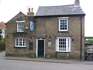
Roxton is a small village and civil parish in the Borough of Bedford, Bedfordshire, England about 7 miles (11 km) north-east of the county town of Bedford.

Wilden is a village and civil parish located in the Borough of Bedford in Bedfordshire, England. The population of 399 in the 2011 Census was estimated at 392 in 2019.

<span class="mw-page-title-main">Chawston</span> Human settlement in England

Chawston is a hamlet in the civil parish of Wyboston, Chawston and Colesden, a part of the Borough of Bedford in the county of Bedfordshire, England.

Wixams railway station is a planned railway station that is due to be built on the Midland Main Line for the Wixams new town development in Bedfordshire, England. It is proposed that the station be between Bedford and Flitwick.

References

  1. 1 2 3 "Proposed amendment of area of benefit of charity – Report by the Head of Corporate Administration" (PDF). Government of the United Kingdom. 3 June 2008.
  2. 1 2 "Campaign success as Freemen's Common saved from development". CPRE Bedfordshire. 27 February 2017.
  3. "Freeman's Common – Bedford Borough Council – Internal Memorandum from the Legal Division" (PDF). 12 July 2001.
  4. "Chronological Tables - Private Acts". Legislation.gov.uk. Retrieved 15 November 2021.
  5. "Freemen's New Common" . The Bedford Times & Bedfordshire Independent. 12 November 1859.
  6. "Grand National Hunt Steeple Chases" . The Bedford Times & Bedfordshire Independent. 6 April 1867.
  7. "Grand National Hunt Steeplechases" . The Bedford Times & Bedfordshire Independent. 4 April 1868.
  8. "Town Council and Local Board" . The Bedford Times & Bedfordshire Independent. 26 December 1871.
  9. "Freemen's Common at Cleat Hill" . The Bedfordshire Times & Independent. 27 May 1932.
  10. "'Botched Process' could result in further urban sprawl". North Bedfordshire Liberal Democrats. 13 November 2008.
  11. "Trust 'under pressure' to sell its land". Times & Citizen . 14 November 2008.
  12. "Land at Freemen's Common Bedford – Joint report of the Director of Finance, Head of Corporate Administration and the Service Manager (Land and Property)" (PDF). 3 February 2009.
  13. "Agenda item – Bedford Borough Local Plan 2035". Government of the United Kingdom. 22 February 2017.
  14. "Bedford Freemen's Common Charity". Government of the United Kingdom.
  15. "Veil of secrecy over future of Freemen's Common". CPRE Bedfordshire. 14 November 2016.
  16. Trustee's Annual Report for the year to March 2022 (Report). House of Industry Estate. 7 December 2022.
  17. Webb, A. (2003). "Land at North Brickhill: Jackmans Farm and Freemans Common, Bedford". archaeologydataservice.ac.uk. Archaeological Services WYAS.