Gaspereau River

Last updated
Gaspereau River
Tubing on Gaspereau River NS July 07.jpg
Tubing on the Gaspereau River
Location
Country Canada
Province Nova Scotia
Physical characteristics
Source 
  location Gaspereau Lake
Mouth  
  location
Minas Basin
  elevation
sea level
Length24.5 km (15.2 mi)
Basin size1,375 km (854 mi)

The Gaspereau River is a river in Kings County, Nova Scotia, Canada.

Contents

It has a length of approximately 24 km from its source at Gaspereau Lake on the South Mountain south of Kentville to its mouth at Hortonville on the Minas Basin. The lower portion of the river is tidal for 6.5 km until Melanson and there are extensive tidal marshes in the lower reaches. The upper 16 km runs swiftly over gravel beds, boulders and bedrock, except for several dammed sections which form narrow and deep channels. Damming for Hydroelectric generation has resulted in twelve major lakes being connected to the river creating a watershed of 1,375 square kilometres. [1] A major tributary is the Black River which joins the Gaspeareau at White Rock. The Black River once flowed further north into the Cornwallis River but connected to the Gaspereau through a natural erosion process known as river capture. [2]

Fishery

Although the Gaspereau is a short river, the riverbed habitat and connecting lakes form an important and productive breeding ground for several species of migratory fish including Gaspereau (Alewife), Rainbow Smelt and Atlantic Salmon. Atlantic Tomcod, Atlantic Sturgeon and Striped Bass spawn in the tidal portion of the river.[ citation needed ]

Gaspereau River salmon is an endangered species Gaspereau river salmon.jpg
Gaspereau River salmon is an endangered species

History and economy

Modern vineyard in the Gaspereau River Valley Luckett Vineyards Gaspereau Valley Nova Scotia.jpg
Modern vineyard in the Gaspereau River Valley

The productive fish runs of the Gaspereau attracted a large settlement of the Mi'kmaq people near Melanson. [3]

Acadians from the settlements at Grand-Pre were also attracted to the fish runs of the river in the late 1600s and named it after the Gaspereau fish with the name "Rivière des Gasparots" first appearing in a 1701 census of Acadia. [4] The New England Planters who settled the area after the Expulsion of the Acadians also harvested fish but also cleared the river banks for farming, notably for apple orchards and built saw mills in the upper reaches of the river. Eventually nine sawmills operated on the river system, creating employment through extensive logging of the South Mountain but also disrupting the ecology of the river with dams and sawdust deposits. After an unsuccessful attempt in 1910, a hydroelectric dam was completed a Stivers Falls near White Rock in 1920. It was the first of a series of hydroelectric dams which replaced the remaining water sawmills with a network of hydroelectric dams. Eventually eight dams and five hydroelectric stations were built along the Gaspereau River, diverting some lakes into the Gaspereau which once flowed into the Avon River. [5] Fish ladders were built to allow some fish migration to continue. A longtime tradition of recreational tubing on the Gaspereau, floating down the river on inner tubes, has grown in popularity in recent years to the point of causing traffic and parking concerns. [6]

Vineyards occupy a significant part of the Gaspereau Valley, up to Grand-Pré, producing white wines, such as based on the L'Acadie blanc grape variety, and red wines (for example, the Marechal Foch variety.[ citation needed ]

Communities

See also

Related Research Articles

<span class="mw-page-title-main">Annapolis Valley</span> Economic region in Nova Scotia, Canada

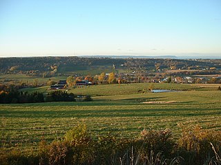
The Annapolis Valley is a valley and region in the province of Nova Scotia, Canada. It is located in the western part of the Nova Scotia peninsula, formed by a trough between two parallel mountain ranges along the shore of the Bay of Fundy. Statistics Canada defines the Annapolis Valley as an economic region, composed of Annapolis County, Kings County, and Hants County.

<span class="mw-page-title-main">Wolfville</span> Town in Nova Scotia, Canada

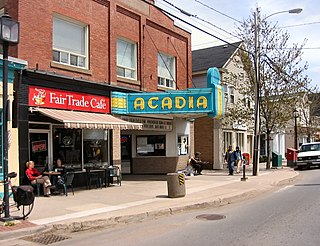
Wolfville is a Canadian town in the Annapolis Valley, Kings County, Nova Scotia, located about 100 kilometres (62 mi) northwest of the provincial capital, Halifax. The town is home to Acadia University and Landmark East School.
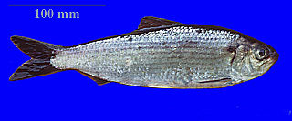
<span class="mw-page-title-main">Bay of Fundy</span> Bay on the east coast of North America

The Bay of Fundy is a bay between the Canadian provinces of New Brunswick and Nova Scotia, with a small portion touching the U.S. state of Maine. It is an arm of the Gulf of Maine. Its tidal range is the highest in the world. The name is probably a corruption of the French word fendu, meaning 'split'.

<span class="mw-page-title-main">Minas Basin</span>

The Minas Basin is an inlet of the Bay of Fundy and a sub-basin of the Fundy Basin located in Nova Scotia, Canada. It is known for its extremely high tides.

<span class="mw-page-title-main">Gaspereau, Nova Scotia</span>

Gaspereau is a rural community located in Kings County, Nova Scotia, Canada.

<span class="mw-page-title-main">Grand-Pré, Nova Scotia</span> Community in Nova Scotia, Canada

Grand-Pré is a Canadian rural community in Kings County, Nova Scotia. Its French name translates to "Great/Large Meadow" and the community lies at the eastern edge of the Annapolis Valley several kilometres east of the town of Wolfville on a peninsula jutting into the Minas Basin surrounded by extensive dyked farm fields, framed by the Gaspereau and Cornwallis Rivers. The community was made famous by Henry Wadsworth Longfellow's poem Evangeline and is today home to the Grand-Pré National Historic Site. On June 30, 2012, the Landscape of Grand-Pré was named a World Heritage Site by UNESCO.

<span class="mw-page-title-main">Annapolis River</span> River in Nova Scotia, Canada

The Annapolis River is a Canadian river located in Nova Scotia's Annapolis Valley.

<span class="mw-page-title-main">Geography of Nova Scotia</span>

Nova Scotia is a province located in Eastern Canada fronting the Atlantic Ocean. One of the Maritime Provinces, Nova Scotia's geography is complex, despite its relatively small size in comparison to other Canadian provinces.

<span class="mw-page-title-main">Tusket</span>

Tusket is a small fishing community located in Yarmouth County, Nova Scotia on route 308.

Kingsport is a small seaside village located in Kings County, Nova Scotia, Canada, on the shores of the Minas Basin. It was famous at one time for building some of the largest wooden ships ever built in Canada.

<span class="mw-page-title-main">St. Croix River (Nova Scotia)</span> River in Nova Scotia, Canada

The St. Croix River is a river in Nova Scotia entirely contained in Hants and Halifax Counties. Its headwaters are Panuke Lake. The river has been exploited for water power. There were water mills in the nineteenth century and in the 1930s three hydroelectric dams were built; they still operate.

<span class="mw-page-title-main">Gaspereau Lake</span>

Gaspereau Lake is a lake in Kings County, Nova Scotia, Canada, about 10 km south of the town of Kentville, Nova Scotia on the South Mountain. It is the largest lake in Kings County, and the fifth largest lake in Nova Scotia. The lake is shallow with dozens of forested islands and hundreds of rocky islets (skerries).

Avonport is a community in the province of Nova Scotia, Canada, located in Kings County between the mouths of the Avon River and the Gaspereau River. Early settlers included the Fillis and Reid families. It was part of the Horton Township settlement and was known as Horton Point until its name was changed to Avonport in 1864.

Canard is a rural community occupying a ridge to the north of the Canard River between the Canard and Habitant Rivers in Kings County in the Canadian province of Nova Scotia. The name comes from the French word for duck which was in turn derived from the Mi'kmaw name for the river which described the large numbers of black ducks once found there.

<span class="mw-page-title-main">Hortonville, Nova Scotia</span>

Hortonville is a community in the Canadian province of Nova Scotia, located in Kings County at the mouth of the Gaspereau River and is part of the Landscape of Grand Pré UNESCO World Heritage Site.

<span class="mw-page-title-main">Nova Scotia wine</span> Canadian wine produced in the Canadian province of Nova Scotia

Nova Scotia wine is Canadian wine produced in the Canadian province of Nova Scotia. Nova Scotia's wineries are primarily organized under the Wine Association of Nova Scotia, though not all wineries are members. The industry began in the late 1970s with the original Grand Pré Winery in the Annapolis Valley of Nova Scotia.

The Canard River is a river in Kings County, Nova Scotia, Canada which drains into the Minas Basin of the Bay of Fundy between the communities of Canard and Starr's Point. It is known for its fertile river banks and extensive dyke land agriculture.

White Rock is a community in Kings County, Nova Scotia near the town of Wolfville.

<span class="mw-page-title-main">St. Margaret's Bay Hydroelectric System</span> Hydroelectric Generating System in Nova Scotia, Canada

The St. Margaret's Bay Hydroelectric System consists of three hydroelectric power plants and the related lake, dam, and river systems driving them. The system is situated within both Lunenburg County and the Halifax Regional Municipality, beginning approximately 2.5 km (1.6 mi) east of the Head of Saint Margarets Bay and approximately 10 km (6.2 mi) southwest of Hammonds Plains. The system is part of the East Indian River watershed and drains 271 square kilometres (105 sq mi), with water storage provided in Lunenburg County by Mill Lake, Coon Pond, Sandy Lake, Wrights Lake, Big Indian Lake, Five Mile Lake and, at times, an overflow from Pockwock Lake in the Halifax Regional Municipality. The system is owned and operated by Nova Scotia Power Inc.

References

  1. Natural History of Nova Scotia, Volume 1, Chapter T8 "Freshwater Hydrology", Nova Scotia Museum (1996) p.152
  2. A Natural History of Kings County, Blomidon Naturalist Society, p. 77-78
  3. Frances L Stewart; Ronald J Nash (1990). "Melanson: a large Micmac village in Kings County, Nova Scotia". Nova Scotia Museum.
  4. "Acadian census 1701" . Retrieved Jun 27, 2013.
  5. "Roy Bishop, "The Black River: Past People and Power", Blomidon Naturalist Society Newsletter, Winter 1994, Vol. 21, No. 4, p. 13-21" (PDF). Archived from the original (PDF) on 2016-06-24. Retrieved 2018-11-04.
  6. "Gaspereau River tubing traffic 'out of control,' residents warn", CBC News, July 18, 2017

45°07′37″N64°16′21″W / 45.12694°N 64.27250°W / 45.12694; -64.27250