
Newfoundland and Labrador is the easternmost province of Canada, in the country's Atlantic region. The province comprises the island of Newfoundland and the continental region of Labrador, having a total size of 405,212 square kilometres. In 2023, the population of Newfoundland and Labrador was estimated to be 533,710. The island of Newfoundland is home to around 94 per cent of the province's population, with more than half residing in the Avalon Peninsula. Labrador borders the province of Quebec, and the French overseas collectivity of Saint Pierre and Miquelon lies about 20 km (12 mi) west of the Burin Peninsula.
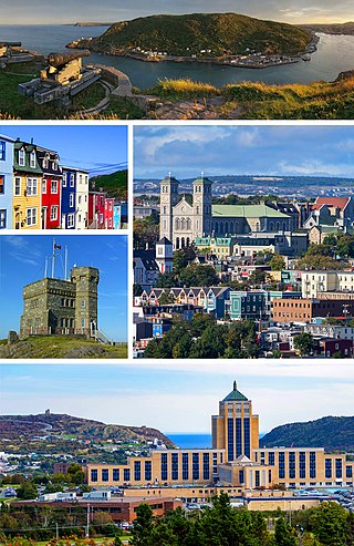
St. John's is the capital and largest city of the Canadian province of Newfoundland and Labrador. It is located on the eastern tip of the Avalon Peninsula on the island of Newfoundland. The city spans 446.04 km2 (172.22 sq mi) and is the easternmost city in North America.

Monkstown is a village in County Cork, Ireland, in the old barony of Kerrycurrihy. It lies 14 kilometres southeast of Cork city on the estuary of the River Lee, facing Great Island and looking onto Monkstown Bay. For census purposes, Monkstown is combined with the nearby town of Passage West, and the combined area has a population of approximately 5,800 residents.

The Irish language was once spoken by some immigrants to the island of Newfoundland before it disappeared in the early 20th century. The language was introduced through mass immigration by Irish speakers, chiefly from counties Waterford, Tipperary and Cork. Local place names in the Irish language include Newfoundland, St. John's, Ballyhack, Cappahayden, Kilbride and St. Bride's, Duntara, Port Kirwan and Skibbereen (Scibirín). The dialect of Irish spoken in Newfoundland is said to resemble the Munster Irish of the 18th century. While the distinct local dialect is now considered extinct, the Irish language is still taught locally and the Gaelic revival organization Conradh na Gaeilge remains active in the province.
St. Bonaventure's College is an independent kindergarten to grade 12 Catholic School in St. John's, Newfoundland and Labrador, Canada. It is located in the St. John's Ecclesiastical District, adjacent to the Roman Catholic Basilica of St. John the Baptist. The school is named in honour of one of the Doctors of the Catholic Church, St. Bonaventure.

The Rooms is a cultural facility in St. John's, Newfoundland and Labrador, Canada. The facility opened in 2005 and houses the Art Gallery of Newfoundland and Labrador, the Provincial Archives of Newfoundland and Labrador and the Provincial Museum of Newfoundland and Labrador.

Rawlins Cross, formed by the intersection of Prescott and Flavin Streets, Monkstown, Rennies Mill, Queens, and Military Roads, is a well known St. John's, Newfoundland and Labrador landmark. Military Road, built in 1773, was one of the first roads in this area that joined Fort William with Fort Townsend. Monkstown Road was built in the early 19th century and Prescott Street around 1840. It is on the edge of Monkstown, which is part of the Georgetown Improvement Area and Downtown St. John's.
The Newfoundland T'Railway Provincial Park is a rail trail located in the Canadian province of Newfoundland and Labrador.

Route 2, also known as Pitts Memorial Drive and Peacekeeper's Way, is a 34.2-kilometre-long (21.3 mi) freeway on the Avalon Peninsula of Newfoundland in the Canadian province of Newfoundland and Labrador. The road provides a direct link from the Trans-Canada Highway (TCH) to downtown St. John's, Newfoundland, which was previously accessible only via city streets such as Topsail Road or Kenmount Road. Initially called the Harbour Arterial, construction began in the early 1970s and was completed in 1979. The $52-million project was funded by the federal and provincial governments. It was renamed by the city council in 1984 after local businessman James Stewart Pitt (1847-1914).
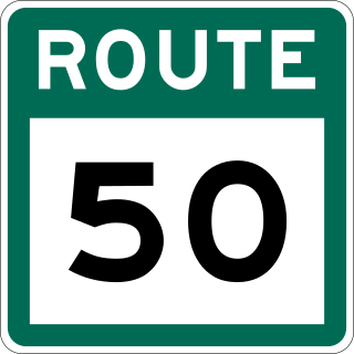
Route 50, also known as Thorburn Road and St. Thomas Line, is a 20.2-kilometre-long (12.6 mi) east-west highway on the Avalon Peninsula of Newfoundland in the Canadian province of Newfoundland and Labrador. It extends from the city of St. John's west to Paradise.
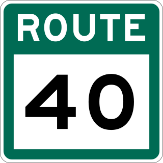
Route 40, also known as Portugal Cove Road, is a 15.3-kilometre-long (9.5 mi) north-south highway on the Avalon Peninsula of Newfoundland, extending from St. John's to the town of Portugal Cove-St. Philips in Newfoundland and Labrador, Canada.
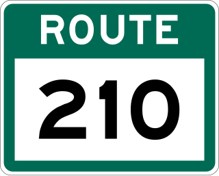
Route 210, also known as the Burin Peninsula Highway and Heritage Run, is a highway that extends through the Burin Peninsula from Goobies to Grand Bank, Newfoundland and Labrador. The maximum speed limit is 90 km/h except through communities and settlements where the speed limit is reduced to 50 km/h. Just after exiting Swift Current, until a few kilometres north of Marystown, much of the landscape is barren, with very few trees prevalent. After entering Marystown, motorists approach a junction where they could turn right to continue their journey on Route 210 until arriving at Grand Bank, or going straight onto Route 220 towards Burin and St. Lawrence. Marystown is the most populous community along the route.

Flatrock is a town in Newfoundland and Labrador. The town had a population of 1,722 in the Canada 2021 Census.

North River is a town on the Avalon Peninsula of Newfoundland in the Canadian province of Newfoundland and Labrador. It was incorporated as a municipality in 1964.

St. Bernard's-Jacques Fontaine is a town in the Canadian province of Newfoundland and Labrador. The town had a population of 433 in the Canada 2021 Census, a drop from 470 in 2011.
The architecture of St. John's, in Newfoundland and Labrador, Canada, has a style distinct from that of the rest of Canada, and its major buildings are remnants of its history and prestige as the first British colonial capital. The city of St. John's has had a long history, with inhabitation dating to the 16th century onwards. As the city grew, so, too, did the landscape. Buildings took a variety of styles according to the styles and means available to build the structures. Starting as a fishing outpost for European fishermen, St. John's consisted mostly of the homes of fishermen, sheds, storage shacks, and wharves. Of course, these structures were small and constructed out of wood. Like many other cities of the time, as the Industrial Revolution took hold and new methods and materials for construction were introduced, the landscape changed as the city grew in width and height. The Great Fire of 1892 destroyed most of the downtown core, and most residential and other wood-frame buildings date from this period. Often compared to San Francisco because of its hilly terrain and steep maze of residential streets, housing in St. John's is typically painted in bright colours, unlike most other parts of Canada.
Rennies Mill is an east end neighbourhood in St. John's, Newfoundland and Labrador and the "area runs along Rennie’s Mill Road from Military Road ... north one block to its termination at Circular [Road] and includes ... buildings on the west side numbers 21 to 79 and on the east side numbers 12 to 54 and the open spaces around them, extending to their rear property lines".

Downtown St. John's is the historic core, and central business district of St. John's, Newfoundland and Labrador, Canada. Located north of St. John's harbour, it is the business, entertainment, and tourism centre with office buildings, hotels, restaurants, and other services.
John M. Tobin was an athlete and politician in Newfoundland. He represented St. John's East Extern in the Newfoundland House of Assembly from 1928 to 1932.

St. John's Ecclesiastical District is a formally-recognized heritage precinct, located in the central part of St. John's, Newfoundland and Labrador. It is composed of separate nodes containing buildings and spaces associated with the Roman Catholic, Anglican, United Church of Canada, and Presbyterian denominations and is representative of the involvement of Christian institutions in the history and political life of St. John's and the province.
