State Route 262 | ||||
---|---|---|---|---|
Route information | ||||
Maintained by GDOT | ||||
Length | 44.4 mi [1] (71.5 km) | |||
Existed | 1949 [2] [3] – present | |||
Major junctions | ||||
South end | ||||
North end | ||||
Location | ||||
Counties | Decatur, Mitchell, Grady. | |||
Highway system | ||||
|
State Route 262 (SR 262) is an L-shaped state highway located in the southwestern part of the U.S. state of Georgia. Its route runs 44.4 miles (71.5 km) within Decatur, Mitchell, and skims the border of Grady.
L is the twelfth letter of the modern English alphabet and the ISO basic Latin alphabet, used in words such as lagoon, lantern, and less.
A state highway, state road, or state route is usually a road that is either numbered or maintained by a sub-national state or province. A road numbered by a state or province falls below numbered national highways in the hierarchy. Roads maintained by a state or province include both nationally numbered highways and un-numbered state highways. Depending on the state, "state highway" may be used for one meaning and "state road" or "state route" for the other.
Southwest Georgia is a fourteen-county region in the U.S. state of Georgia. It has a 2010 census population of 496,433, and is the least populated region in Georgia, just slightly behind Southeast Georgia. Additionally, the area has historically been the poorest region of the state since at least 1995, when over 25% of the residents were in poverty.
SR 262 begins at an intersection with US 27/SR 1 (Tallahassee Highway) southeast of Attapulgus, in Decatur County. Here, US 27/SR 1 south almost immediately enter Florida and head toward Tallahassee. [1]
An intersection is an at-grade junction where two or more roads meet or cross. Intersections may be classified by number of road segments, traffic controls, and/or lane design.
U.S. Route 27 (US 27) is a 356.088-mile-long (573.068 km) U.S. Highway in the U.S. state of Georgia. It travels south-to-north through the western part of the state near the Alabama state line. The whole route is Governor's Road Improvement Program (GRIP) corridor EDS-27, providing the bulk of the Tallahassee, Florida–Chattanooga, Tennessee corridor. All of US 27 in Georgia is concurrent with State Route 1 (SR 1) and is also designated as the Martha Berry Highway. It connects Bainbridge, Colquitt, Blakely, Cuthbert, Lumpkin, Cusseta, Columbus, LaGrange, Carrollton, Bremen, Cedartown, Rome, Summerville, LaFayette, Fort Oglethorpe, and Rossville.
Attapulgus is a city in Decatur County, Georgia, United States. As of the 2010 census, the city had a population of 449.
SR 262 heads to the northeast and then swings around to the northwest and the north-northwest. It intersects Wautauga Road, which heads southwest to Attapulgus. It then passes Conyers Cemetery and heads north to Lake Douglas Road, where the route turns to the east. Northeast of Lake Douglas Road is Hines Perkins Road, which heads east-southeast and enters Grady County and leads to Nickleville. The route then curves back to the west and turns north just before Cedar Grove Cemetery. Farther to the north, in Climax, SR 262 has a short concurrency with US 84/SR 38 (Thomasville Road) and crosses a CSX Transportation railroad line. Just northeast of Climax is Fleatown Cemetery. Farther to the north, SR 309 (Old Pelham Road) west and Mars Hill Church Road east. The highway heads nearly due north to an intersection with SR 97 (Vada Road) south. Here, SR 97 and SR 262 from a brief concurrency into the unincorporated community of Vada, where SR 262 splits onto a nearly due east route along the Decatur-Mitchell County line. Not much farther to the east, the road runs along the Grady-Mitchell County line, and it intersects the route of former SR 179. Then, it continues to the eastto SR 112 just before it curves to the northeast to meet its northern terminus, an intersection with SR 93 southwest of Pelham. [1]
Grady County is a county located in the U.S. state of Georgia. As of the 2010 census, the population was 25,011. The county seat is Cairo.
Climax is a city in Decatur County, Georgia, United States. The town was named "Climax" because it is located at the highest point of the railroad between Savannah, Georgia, and the Chattahoochee River. The population was 280 at the 2010 census.
A concurrency in a road network is an instance of one physical roadway bearing two or more different route numbers. When two roadways share the same right-of-way, it is sometimes called a common section or commons. Other terminology for a concurrency includes overlap, coincidence, duplex, triplex, multiplex, dual routing or triple routing.
No section of SR 262 is part of the National Highway System. [4]
The National Highway System (NHS) is a network of strategic highways within the United States, including the Interstate Highway System and other roads serving major airports, ports, rail or truck terminals, railway stations, pipeline terminals and other strategic transport facilities. Altogether, it constitutes the largest highway system in the world.
SR 262 was established in 1949 along an alignment from Vada to its northern terminus. [2] [3] In 1950, that entire section was paved. [3] [5] By 1960, the route was designated and paved along the section from the southern terminus to Vada. [6] [7]
County | Location | mi [1] | km | Destinations | Notes |
---|---|---|---|---|---|
Decatur | | 0.0 | 0.0 | Southern terminus | |
Climax | 14.7 | 23.7 | Southern end of US 84/SR 38 concurrency | ||
15.0 | 24.1 | Northern end of US 84/SR 38 concurrency | |||
| 23.2 | 37.3 | Northern terminus of SR 309; western terminus of Mars Hill Church Road | ||
| 28.5 | 45.9 | Southern end of SR 97 concurrency | ||
Decatur–Mitchell county line | Vada | 29.5 | 47.5 | Northern end of SR 97 concurrency | |
Grady–Mitchell county line | | 38.6 | 62.1 | ||
Mitchell | | 44.4 | 71.5 | Northern terminus | |
1.000 mi = 1.609 km; 1.000 km = 0.621 mi
|
Interstate 985 (I-985) is a 25.01-mile-long (40.25 km) Auxiliary Interstate Highway in the northeastern part of the U.S. state of Georgia. It links the Atlanta metropolitan area to the city of Gainesville via Suwanee. I-985 is also known as the Sidney Lanier Parkway and is also designated as unsigned State Route 419. The roadway was designated as I-985 in 1985.
State Route 120 (SR 120) is a 90.7-mile-long (146.0 km) state highway that runs west-to-east through portions of Haralson, Paulding, Cobb, Fulton, and Gwinnett counties in northwestern part of the U.S. state of Georgia.
State Route 300, is a 107-mile-long (172 km) state highway in the southern part of the U.S. state of Georgia. Its southern terminus is at the Florida state line south-southeast of Thomasville, where the roadway continues as US 19/SR 57. This is also the southern terminus of SR 3, with which US 19 and SR 300 travel concurrently through the southern part of the state. Its northern terminus is at Interstate 75 (I-75) in Cordele.
State Route 255 (SR 255) is a 19.7-mile-long (31.7 km) S-shaped state highway located in the North Georgia mountains section of the U.S. state of Georgia. It travels through White and Habersham counties.
State Route 112 (SR 112) is a 195-mile-long (314 km) state highway that travels in a generally southwest-to-northeast orientation in the southwestern and central parts of the U.S. state of Georgia. It passes through portions of Grady, Mitchell, Worth, Turner, Wilcox, Pulaski, Bleckley, Twiggs, Wilkinson, and Baldwin counties, and connects the Cairo and Milledgeville areas of the state.
State Route 8 (SR 8) is a 183-mile-long (295 km) state highway that travels west-to-east through portions of Haralson, Carroll, Douglas, Cobb, Fulton, DeKalb, Gwinnett, Barrow, Clarke, Oconee, Madison, Franklin, and Hart counties, bisecting the northern part of the U.S. state of Georgia. The highway travels from its western terminus at US 78 and SR 4 at the Alabama state line west of Tallapoosa to its eastern terminus at US 29 at the South Carolina state line at the south end of Lake Hartwell. The highway is concurrent with either US 29 or US 78 for its entire length.
State Route 36 (SR 36) is a 95.2-mile-long (153.2 km) state highway that travels southwest-to-northeast through portions of Harris, Talbot, Upson, Lamar, Butts, and Newton counties in the central part of the U.S. state of Georgia. The highways connects the Waverly Hall area with Covington, via Thomaston, Barnesville, and Jackson.
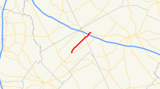
State Route 43 (SR 43) is a 25.7-mile-long (41.4 km) state highway that travels southwest-to-northeast through portions of McDuffie and Lincoln counties in the east-central part of the U.S. state of Georgia. The highway connects the northern part of the Thomson area to the South Carolina state line, via Lincolnton.
State Route 278 (SR 278) is a 10.9-mile-long (17.5 km) rural southwest–northeast state highway located in the central part of the U.S. state of Georgia.
State Route 272 (SR 272) is a 15.4-mile-long (24.8 km) north–south state highway located in the east-central part of the U.S. state of Georgia. Its path is entirely within Washington County.
State Route 271 (SR 271) is a 7.6-mile-long (12.2 km) east–west state highway located in the west-central part of the U.S. state of Georgia. Its route is within Schley and Sumter counties.
State Route 270 (SR 270) is a 12.7-mile-long (20.4 km) east–west state highway located in the southern part of the U.S. state of Georgia. Its route is within Mitchell and Colquitt counties.
State Route 268 (SR 268) is a 22.9-mile-long (36.9 km) southwest–northeast state highway located in the south-central part of the U.S. state of Georgia. It travels within portions of Coffee and Jeff Davis counties.
State Route 266 (SR 266) is a 18.2-mile-long (29.3 km) east–west state highway located in the southwestern part of the U.S. state of Georgia. Its path is within Clay and Randolph counties.
State Route 254 (SR 254) is a 10.8-mile-long (17.4 km) southwest-northeast state highway located in the northeastern part of the U.S. state of Georgia. It travels through portions of Hall and White counties.
State Route 60 (SR 60) is a 90.1-mile-long (145.0 km) state highway that travels southeast-to-northwest through portions of Jackson, Hall, Lumpkin, Union, and Fannin counties in the north-central part of the U.S. state of Georgia. The highway connects the Braselton area with McCaysville at the Tennessee state line, via Gainesville and Dahlonega.
State Route 241 (SR 241) is a 5.6-mile-long (9.0 km) southwest-northeast state highway located in the southwestern part of the U.S. state of Georgia. It exists entirely within Decatur County.
State Route 98 (SR 98) is a 36.6-mile-long (58.9 km) state highway that travels southeast-to-northwest through portions of Madison, Jackson, and Banks counties in the northeastern part of the U.S. state of Georgia. The highway connects Comer and Homer, via Danielsville, Commerce, and Maysville.
There are at least thirteen current and three former special routes of U.S. Route 27.
State Route 230 (SR 230) is a 59.2-mile-long (95.3 km) west–east state highway in the central part of the U.S. state of Georgia. It travels in a northern arc through portions of Dooly, Pulaski, and Dodge counties.
KML file (edit • help) |
Wikimedia Commons has media related to Georgia State Route 262 . |