Georgia State Route 278

Last updated

Georgia 278.svg

State Route 278
Montrose Road
Georgia state route 278 map.png
Route information
Maintained by GDOT
Length 10.9 mi [1] (17.5 km)
Existed 1950 [2] [3] – present
Major junctions
South endGeorgia 26.svg SR 26 northeast of Cochran
North endUS 80.svgGeorgia 19.svg US 80 / SR 19 in Montrose
Location
Counties Bleckley, Laurens
Highway system
  • Georgia State Routes
US 278.svg US 278 SR 279 Georgia 279.svg

State Route 278 (SR 278) is a rural southwest-northeast state highway located in the central part of the U.S. state of Georgia.

A state highway, state road, or state route is usually a road that is either numbered or maintained by a sub-national state or province. A road numbered by a state or province falls below numbered national highways in the hierarchy. Roads maintained by a state or province include both nationally numbered highways and un-numbered state highways. Depending on the state, "state highway" may be used for one meaning and "state road" or "state route" for the other.

Central Georgia is the area containing the metropolitan region surrounding the city of Macon, in Bibb County in the U.S. state of Georgia. It abuts the Atlanta metropolitan area, just to the north.

U.S. state constituent political entity of the United States

In the United States, a state is a constituent political entity, of which there are currently 50. Bound together in a political union, each state holds governmental jurisdiction over a separate and defined geographic territory and shares its sovereignty with the federal government. Due to this shared sovereignty, Americans are citizens both of the federal republic and of the state in which they reside. State citizenship and residency are flexible, and no government approval is required to move between states, except for persons restricted by certain types of court orders. Four states use the term commonwealth rather than state in their full official names.

Contents

Route description

SR 278 is not part of the National Highway System, a system of routes important to the nation's economy, mobility and defense. [4] [5]

National Highway System (United States) highway system in the United States

The National Highway System (NHS) is a network of strategic highways within the United States, including the Interstate Highway System and other roads serving major airports, ports, rail or truck terminals, railway stations, pipeline terminals and other strategic transport facilities. Altogether, it constitutes the largest highway system in the world.

Bleckley County

SR 278 begins at an intersection with SR 26 northeast of Cochran in Bleckley County. The route heads north, then curves to the northeast to an intersection with Walker Mullis Road. Farther to the northeast is an intersection, with Cary Road heading to the northwest and Cary Salem Road heading to the southeast. A short distance later, Goldboro Road heads to the east. After that, is an intersection with Robert P. Lassiter Road. Then, the highway intersects Pea Ridge Road, which heads to the northwest. SR 278 then intersects Mt. Carmel Church Road and Talmadge Coley Road in rapid succession. [1] [6]

Intersection (road) A road junction where two or more roads either meet or cross at grade

An intersection is an at-grade junction where two or more roads meet or cross. Intersections may be classified by number of road segments, traffic controls, and/or lane design.

Georgia State Route 26 highway in Georgia

State Route 26 (SR 26) is a 271.1-mile-long (436.3 km) state highway that travels west-to-east through portions of Chattahoochee, Marion, Schley, Macon, Houston, Pulaski, Bleckley, Laurens, Johnson, Emanuel, Bulloch, Bryan, Effingham, and Chatham counties through the central part of the U.S. state of Georgia. It crosses nearly the entire width of the state, connecting Cusseta, on the southeastern edge of Fort Benning, near Columbus to Tybee Island on the Atlantic coast near Savannah, via Buena Vista, Ellaville, Oglethorpe, Hawkinsville, Cochran, Dublin, Swainsboro, Statesboro, and Savannah.

Cochran, Georgia City in Georgia, United States

Cochran is a city in Bleckley County, Georgia, United States. As of the 2010 census, the city had a population of 5,150. The city is the county seat of Bleckley County.

Laurens County

After Talmadge Coley Road, SR 278 crosses into Laurens County. It then intersects Laurens County Road 386 (The Rock Road). A short distance later, the road crosses over, but does not have an interchange with Interstate 16 (I-16). Northeast of I-16, the highway enters the city limits of Montrose, and meets its northern terminus, an intersection with US 80/SR 19 (Wade Street) in town. [1] [6]

Laurens County, Georgia County in the United States

Laurens County is a county located in the U.S. state of Georgia. As of the 2010 census, the population was 48,434. The county seat is Dublin. The county was founded on December 10, 1807, and named after Lieutenant Colonel John Laurens, an American soldier and statesman from South Carolina during the American Revolutionary War.

Interchange (road) road junction, typically using grade separation

In the field of road transport, an interchange is a road junction that uses grade separation, and typically one or more ramps, to permit traffic on at least one highway to pass through the junction without interruption from other crossing traffic streams. It differs from a standard intersection, where roads cross at grade. Interchanges are almost always used when at least one road is a controlled-access highway or a limited-access divided highway (expressway), though they are sometimes used at junctions between surface streets.

Interstate 16 (I-16), also known as Jim Gillis Historic Savannah Parkway, is an east–west Interstate Highway located entirely within the U.S. state of Georgia. It carries the hidden designation of State Route 404 (SR 404) for its entire length. I-16 travels from downtown Macon, at an interchange with I-75 and SR 540 to downtown Savannah at Montgomery Street. It connects Macon and Savannah, via Dublin, Metter, and Pooler. I-16's unsigned designation of SR 404 has a spur that is signed in Savannah.

History

SR 278 was established in 1950 along the same alignment as it takes today. In this year the section of SR 278 in Bleckley County was paved. [2] [3] The rest of the route was paved in 1970. [7] [8] The highway has not experienced any major changes to its routing since 1970. [6] [8]

Major intersections

CountyLocationmi [1] kmDestinationsNotes
Bleckley 0.00.0Georgia 26.svg SR 26 (Dykes Street) Cochran, Dudley Southern terminus
Laurens Montrose 10.917.5US 80.svgGeorgia 19.svg US 80 / SR 19 (Wade Street) Allentown, Dudley Northern terminus
1.000 mi = 1.609 km; 1.000 km = 0.621 mi

See also

Related Research Articles

Georgia State Route 120 highway in Georgia

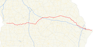
State Route 120 (SR 120) is a 90.7-mile-long (146.0 km) state highway that runs west-to-east through portions of Haralson, Paulding, Cobb, Fulton, and Gwinnett counties in northwestern part of the U.S. state of Georgia.

Georgia State Route 365 highway in Georgia

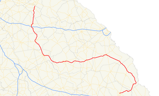
State Route 365 (SR 365) is a 69.5-mile-long (111.8 km) state highway that travels within portions of Gwinnett, Hall, Habersham, and Stephens counties. It begins at exit 113 on Interstate 85 (I-85), at the southeastern edge of Suwanee. This is also the southern terminus of I-985. It continues from that point concurrent with I-985 for the entire length of that freeway. Eventually, U.S. Route 23 (US 23) also joins the concurrency. The highway heads northeast through Gainesville and Toccoa, before it terminates at the South Carolina state line, southwest of Westminster, South Carolina.

U.S. Route 1 in Georgia highway in Georgia

U.S. Route 1 (US 1) in the U.S. state of Georgia, which is concurrent for almost its entire length with State Route 4 (SR 4), is a highway traversing south-to-north through portions of Charlton, Ware, Bacon, Appling, Toombs, Emanuel, Jefferson, and Richmond counties in the southeastern and east-central parts of the state. In Georgia, the highway originates at US 1/US 23/US 301/SR 15 at the St. Marys River and the Florida state line, where SR 4 and SR 15 reach their southern terminus. It travels to its northern terminus at US 1/US 25/US 78/US 278/SC 121 at the Savannah River and the South Carolina state line in Augusta. Here, SR 10 reaches its eastern terminus, and SR 121 reaches its northern terminus.

Georgia State Route 24 highway in Georgia

State Route 24 (SR 24) is a 221.8-mile-long (357.0 km) state highway that travels south-to-north in an S-shaped curve through portions of Bulloch, Screven, Burke, Jefferson, Washington, Baldwin, Putnam, Morgan, and Oconee counties in the east-central part of the U.S. state of Georgia. The highway connects Statesboro with the Watkinsville area, via Waynesboro, Louisville, Sandersville, Milledgeville, Eatonton, and Madison.

Georgia State Route 383 highway in Georgia

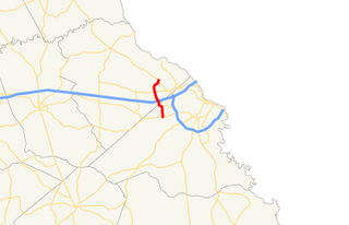
State Route 383 (SR 383) is a 7.4-mile-long (11.9 km) state highway in the east-central part of the U.S. state of Georgia. It is located within portions of Richmond and Columbia counties. It connects Fort Gordon with Martinez and Evans.

Georgia State Route 112 highway in Georgia

State Route 112 (SR 112) is a 195-mile-long (314 km) state highway that travels in a generally southwest-to-northeast orientation in the southwestern and central parts of the U.S. state of Georgia. It passes through portions of Grady, Mitchell, Worth, Turner, Wilcox, Pulaski, Bleckley, Twiggs, Wilkinson, and Baldwin counties, and connects the Cairo and Milledgeville areas of the state.

Georgia State Route 23 highway in Georgia

State Route 23 (SR 23) is a 240.0-mile-long (386.2 km) state highway that travels south-to-north through portions of Charlton, Brantley, Wayne, Long, Tattnall, Candler, Emanuel, Jenkins, and Burke counties in the southeastern and east-central parts of the U.S. state of Georgia. The highway connects the Florida state line, south-southwest of Saint George with the southern part of the Augusta metropolitan area, via Folkston, Nahunta, Jesup, Ludowici, Glennville, Reidsville, Metter, Twin City, and Millen.

Georgia State Route 31 highway in Georgia

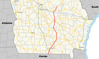
State Route 31 (SR 31) is a 166.9-mile-long (268.6 km) state highway that travels south-to-north through portions of Lowndes, Lanier, Clinch, Atkinson, Coffee, Telfair, Wheeler, Dodge, Laurens, and Johnson counties in the south-central part of the U.S. state of Georgia. The highway connects the Florida state line, south of Clyattville with Wrightsville, via Valdosta, Douglas, and Dublin.

Georgia State Route 36 highway in Georgia

State Route 36 (SR 36) is a 95.2-mile-long (153.2 km) state highway that travels southwest-to-northeast through portions of Harris, Talbot, Upson, Lamar, Butts, and Newton counties in the central part of the U.S. state of Georgia. The highways connects the Waverly Hall area with Covington, via Thomaston, Barnesville, and Jackson.

Georgia State Route 47 highway in Georgia

State Route 47 (SR 47) is an 83.9-mile-long (135.0 km) arc-shaped state highway that travels through portions of Taliaferro, Wilkes, Lincoln, Columbia, McDuffie, and Jefferson counties in the east-central part of the U.S. state of Georgia. The highway connects Crawfordville and Wrens, via Washington, Lincolnton, and Harlem.

Georgia State Route 51 highway in Georgia

State Route 51 (SR 51) is a 63.6-mile-long (102.4 km) state highway that travels west-to-east through portions of Hall, Banks, Franklin, and Hart counties in the northeastern part of the U.S. state of Georgia. The highway connects Lula with Lake Hartwell, via Homer, Carnesville, and Hartwell.

Georgia State Route 268 highway in Georgia

State Route 268 (SR 268) is a 22.9-mile-long (36.9 km) southwest–northeast state highway located in the south-central part of the U.S. state of Georgia. It travels within portions of Coffee and Jeff Davis counties.

Georgia State Route 262 highway in Georgia

State Route 262 (SR 262) is a 44.4-mile-long (71.5 km) L-shaped state highway located in the southwestern part of the U.S. state of Georgia. It travels within portions of within Decatur and Mitchell counties, and skims the border of Grady County.

Georgia State Route 257 highway in Georgia

State Route 257 (SR 257) is a southwest–to–northeast state highway located in the central part of the U.S. state of Georgia. It travels from Cordele to Dublin, via Hawkinsville. Its routing is located within portions of Crisp, Dooly, Wilcox, Pulaski, Bleckley, Dodge, and Laurens counties.

Georgia State Route 254 highway in Georgia

State Route 254 (SR 254) is a 10.8-mile-long (17.4 km) southwest-northeast state highway located in the northeastern part of the U.S. state of Georgia. It travels through portions of Hall and White counties.

Georgia State Route 243 highway in Georgia

State Route 243 (SR 243) was a 21.2-mile-long (34.1 km) north–south state highway located in the central part of the U.S. state of Georgia. It existed in portions of Wilkinson and Baldwin counties.

U.S. Route 278 in Georgia highway in Georgia

U.S. Route 278 (US 278) in the U.S. state of Georgia is an east–west United States Highway traversing the north-central portion of the state. The highway travels from its western terminus as US 278/SR 74 at the Alabama state line near Esom Hill to its eastern terminus at US 1/US 25/US 78/US 278/SC 121 in the Augusta metropolitan area where it crosses the Savannah River into South Carolina.

U.S. Route 25 in Georgia highway in Georgia, United States

U.S. Route 25 (US 25) is a U.S. Highway that travels from Brunswick, Georgia to the Kentucky-Ohio state line, where Covington, Kentucky meets Cincinnati, Ohio at the Ohio River. In the U.S. state of Georgia, US 25 is as a 190.0-mile-long (305.8 km) highway that travels south to north in the eastern part of the state, near the Atlantic Ocean, serving Brunswick, Statesboro, and Augusta on its path from Brunswick to South Carolina at the Savannah River. Its routing travels through portions of Glynn, Wayne, Long, Tattnall, Evans, Bulloch, Jenkins, Burke, and Richmond counties.

Georgia State Route 223 highway in Georgia

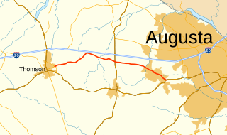
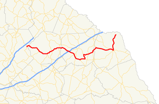
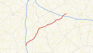
State Route 223 (SR 223) is a 20.9-mile-long (33.6 km) east–west state highway in the east-central part of the U.S. state of Georgia. Its routing travels through portions of McDuffie, Columbia, and Richmond counties. The highway connects Thomson with Grovetown, Augusta, and Fort Gordon. Except for the portions in Thomson, Grovetown, and Augusta, the highway is relatively rural.

Georgia State Route 80 highway in Georgia

State Route 80 (SR 80) is a 84.0-mile-long (135.2 km) state highway that predominantly travels in a west–east direction in the east central part of the U.S. state of Georgia. It exists within portions of Wilkes, Warren, Glascock, Jefferson, and Burke counties.

References

  1. 1 2 3 4 Google (February 15, 2013). "Overview of Georgia State Route 278" (Map). Google Maps . Google. Retrieved February 15, 2013.
  2. 1 2 Georgia State Highway System (PDF) (Map). Cartography by GSHD. Georgia State Highway Department. April 1, 1949. Retrieved February 15, 2013.[ permanent dead link ]
  3. 1 2 Georgia State Highway System (PDF) (Map). Cartography by GSHD. Georgia State Highway Department. August 1, 1950. Retrieved February 15, 2013.[ permanent dead link ]
  4. National Highway System: Georgia (PDF) (Map). Federal Highway Administration. December 2003. Retrieved February 15, 2013.
  5. Natzke, Stefan; Neathery, Mike; Adderly, Kevin (September 26, 2012). "What is the National Highway System?". National Highway System. Federal Highway Administration. Retrieved February 15, 2013.
  6. 1 2 3 Georgia Highway Map (PDF) (Map) (2013–14 ed.). Cartography by GDOT. Georgia Department of Transportation. § H9–I9. Retrieved February 15, 2013.[ permanent dead link ]
  7. Georgia State Highway System (PDF) (Map). Cartography by GSHD. Georgia State Highway Department. 1969. Retrieved February 15, 2013.[ permanent dead link ]
  8. 1 2 Georgia State Highway System (PDF) (Map). Cartography by GSHD. Georgia State Highway Department. 1970. Retrieved February 15, 2013.[ permanent dead link ]

Route map: Google

KML file (edithelp)
KML is from Wikidata