Georgia State Route 356

Last updated

Georgia 356.svg

State Route 356
Georgia state route 356 map.png
Route information
Maintained by GDOT
Length 10.8 mi [1] (17.4 km)
Existed 1966 (1966) [2] [3] – present
Major junctions
West endGeorgia 17.svgGeorgia 75.svg SR 17 / SR 75 in Robertstown
East endGeorgia 197.svg SR 197 northeast of Batesville
Location
Counties White, Habersham
Highway system
  • Georgia State Routes
Georgia 355.svg SR 355 SR 358 Georgia 358.svg

State Route 356 (SR 356) is a 10.8-mile-long (17.4 km) west–east state highway located in the northeast part of the U.S. state of Georgia. Its routing is located within portions of White and Habersham counties. Virtually the entire route is contained within the Chattahoochee-Oconee National Forest.

Northeast Georgia

Northeast Georgia is a region of Georgia in the United States. The northern part is also in the north Georgia mountains, while the southern part is still hilly but much flatter in topography. Northeast Georgia is also served by the Asheville/Spartanburg/Greenville/Anderson market.

U.S. state constituent political entity of the United States

In the United States, a state is a constituent political entity, of which there are currently 50. Bound together in a political union, each state holds governmental jurisdiction over a separate and defined geographic territory and shares its sovereignty with the federal government. Due to this shared sovereignty, Americans are citizens both of the federal republic and of the state in which they reside. State citizenship and residency are flexible, and no government approval is required to move between states, except for persons restricted by certain types of court orders. Four states use the term commonwealth rather than state in their full official names.

Georgia (U.S. state) State of the United States of America

Georgia is a state in the Southeastern United States. It began as a British colony in 1733, the last and southernmost of the original Thirteen Colonies to be established. Named after King George II of Great Britain, the Province of Georgia covered the area from South Carolina south to Spanish Florida and west to French Louisiana at the Mississippi River. Georgia was the fourth state to ratify the United States Constitution, on January 2, 1788. In 1802–1804, western Georgia was split to the Mississippi Territory, which later split to form Alabama with part of former West Florida in 1819. Georgia declared its secession from the Union on January 19, 1861, and was one of the original seven Confederate states. It was the last state to be restored to the Union, on July 15, 1870. Georgia is the 24th largest and the 8th most populous of the 50 United States. From 2007 to 2008, 14 of Georgia's counties ranked among the nation's 100 fastest-growing, second only to Texas. Georgia is known as the Peach State and the Empire State of the South. Atlanta, the state's capital and most populous city, has been named a global city. Atlanta's metropolitan area contains about 55% of the population of the entire state.

Contents

SR 356 used to travel farther to the southwest, since it contained what is the entire standalone section of SR 75 Alternate. The roadway was built in the early 1960s, with its original segment being designated as SR 356 by the middle of the decade. During the early to mid 1970s, the current segment was designated as part of the route. During the early part of the next decade, the original segment was redesignated as part of SR 75 Alternate.

Route description

SR 356 begins at an intersection with SR 17/SR 75 (Unicoi Turnpike) in Robertstown just northwest of Helen in White County. The route travels to the northeast and enters the Chattahoochee-Oconee National Forest. Then, it passes through part of Unicoi State Park. Inside the park, it passes just south of Unicoi Lake. The highway has a long, gradual curve to the northeast, and passes to the north of Innsbruck Resort & Golf Club. After traveling through the unincorporated community of Sautee Nacoochee, it enters Habersham County. Almost immediately, it begins a curve to the southeast. Then, it passes over the Left and Right forks of the Soque River before meeting its eastern terminus, an intersection with SR 197 northeast of Batesville.

Intersection (road) A road junction where two or more roads either meet or cross at grade

An intersection is an at-grade junction where two or more roads meet or cross. Intersections may be classified by number of road segments, traffic controls, and/or lane design.

Georgia State Route 17 highway in Georgia

State Route 17 (SR 17) is a 294-mile-long (473 km) state highway that travels south-to-north through portions of Chatham, Effingham, Screven, Jenkins, Burke, Jefferson, Warren, McDuffie, Wilkes, Elbert, Hart, Franklin, Stephens, Habersham, White, and Towns counties in the east-central and northeastern parts of the U.S. state of Georgia. The highway connects Interstate 16 (I-16) in Bloomingdale to the North Carolina state line, northwest of Hiawassee, via Millen, Louisville, Wrens, Thomson, Washington, Elberton, Royston, Toccoa, Clarkesville, and Hiawassee.

Georgia State Route 75 highway in Georgia

State Route 75 (SR 75) is a 33.4-mile-long (53.8 km) state highway that runs south-to-north through portions of White and Towns counties in the northern part of the U.S. state of Georgia. It connects the towns of Cleveland and Hiawassee with Helen, Macedonia, and the North Carolina state line.

SR 356 is not part of the National Highway System, a system of roadways important to the nation's economy, defense, and mobility. [4]

National Highway System (United States) highway system in the United States

The National Highway System (NHS) is a network of strategic highways within the United States, including the Interstate Highway System and other roads serving major airports, ports, rail or truck terminals, railway stations, pipeline terminals and other strategic transport facilities. Altogether, it constitutes the largest highway system in the world.

History

The roadway that would become SR 75 from northwest of Cleveland to northwest of Helen and the entire length of current SR 356 was built between 1960 and 1963. [2] [5]

Cleveland, Georgia City in Georgia, United States

Cleveland is a city in White County, Georgia, United States, located 90 miles (140 km) northeast of Atlanta and 128 miles (206 km) southeast of Chattanooga, Tennessee. Its population was 3,410 at the 2010 census. It is the county seat of White County.

Between 1963 and 1966, the entire original segment was designated as part of SR 356. [2] [3]

In 1972, the current segment was designated as part of the route. [6] [7]

In the early 1980s, the original segment was renumbered as SR 75 Alternate. [8] [9]

Major intersections

CountyLocationmi [1] kmDestinationsNotes
White 0.00.0Georgia 17.svgGeorgia 75.svg SR 17 / SR 75 (Unicoi Turnpike) Helen, Clarkesville, Cleveland, Hiawassee Western terminus
Habersham Batesville 10.817.4Georgia 197.svg SR 197  Clarkesville Eastern terminus
1.000 mi = 1.609 km; 1.000 km = 0.621 mi

See also

Related Research Articles

Interstate 985 (I-985) is a 25.01-mile-long (40.25 km) Auxiliary Interstate Highway in the northeastern part of the U.S. state of Georgia. It links the Atlanta metropolitan area to the city of Gainesville via Suwanee. I-985 is also known as the Sidney Lanier Parkway and is also designated as unsigned State Route 419. The roadway was designated as I-985 in 1985.

Georgia State Route 3 highway in Georgia

State Route 3 (SR 3) is a 351-mile-long (565 km) state highway that travels south-to-north through portions of the western part of the U.S. state of Georgia, roughly paralleling Interstate 75 (I-75). The highway travels from its southern terminus at the Florida state line, where SR 3 and SR 300 both reach their southern terminus, concurrent with US 19. Here, US 19 travels concurrent with State Road 57, 12 miles (19 km) south-southeast of Thomasville. SR 3 travels through portions of Thomas, Mitchell, Dougherty, Lee, Sumter, Schley, Taylor, Upson, Pike, Spalding, Henry, Clayton, Fulton, Cobb, Bartow, Gordon, Whitfield, and Catoosa counties to its northern terminus at the Tennessee state line, in East Ridge, where US 41/US 76 continue, concurrent with State Route 8. It travels through Thomasville, Albany, Griffin, Atlanta, Calhoun, and Dalton.

Georgia State Route 15 highway in Georgia

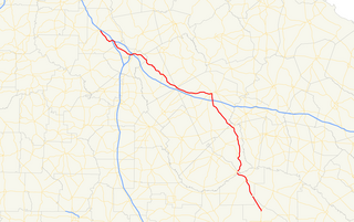
State Route 15 (SR 15) is a 346-mile-long (557 km) state highway that travels south-to-north across the entire length of the U.S. state of Georgia, east of its centerline. It connects the Florida state line, south-southeast of Folkston with the North Carolina state line, in Dillard, via Folkston, Vidalia, Sandersville, Athens, Demorest, and Clayton.

Georgia State Route 16 highway in Georgia

State Route 16 (SR 16) is a 179-mile-long (288 km) state highway that travels west-to-east through portions of Haralson, Carroll, Coweta, Spalding, Butts, Jasper, Putnam, Hancock, and Warren counties in the western and central parts of the U.S. state of Georgia. The highway connects the southeastern portion of Carroll County, northwest of Mount Zion to Warrenton, via Carrollton, Newnan, Griffin, Monticello, Eatonton, and Sparta.

Georgia State Route 365 highway in Georgia

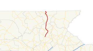
State Route 365 (SR 365) is a 69.5-mile-long (111.8 km) state highway that travels within portions of Gwinnett, Hall, Habersham, and Stephens counties. It begins at exit 113 on Interstate 85 (I-85), at the southeastern edge of Suwanee. This is also the southern terminus of I-985. It continues from that point concurrent with I-985 for the entire length of that freeway. Eventually, U.S. Route 23 (US 23) also joins the concurrency. The highway heads northeast through Gainesville and Toccoa, before it terminates at the South Carolina state line, southwest of Westminster, South Carolina.

Georgia State Route 255 highway in Georgia

State Route 255 (SR 255) is a 19.7-mile-long (31.7 km) S-shaped state highway located in the North Georgia mountains section of the U.S. state of Georgia. It travels through White and Habersham counties.

Georgia State Route 376 highway in Georgia

State Route 376 (SR 376) is a 16.0-mile-long (25.7 km) east–west state highway that travels within portions of Lowndes and Echols counties in the southern part of the U.S. state of Georgia. It connects Clyattville with the Statenville area, via Lake Park. The roadway was built in the late 1950s and designated as SR 376 in 1972.

Georgia State Route 384 highway in Georgia

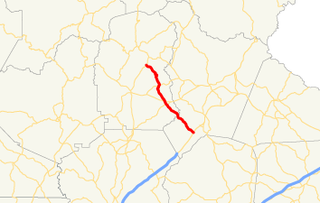
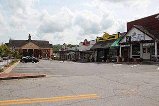
State Route 384 (SR 384) is a 15.6-mile-long (25.1 km) state highway in the northeast part of the U.S. state of Georgia. It travels southeast-to-northwest along Duncan Bridge Road from US 23/SR 365 in the western part of Baldwin to SR 75 southeast of Helen. The route serves as a gateway to Helen and the North Georgia mountains.

Georgia State Route 362 highway in Georgia

State Route 362 (SR 362) is a 32.5-mile-long (52.3 km) state highway located in the west-central part of the U.S. state of Georgia. It is mainly a rural highway, traveling through parts of Meriwether, Pike, and Spalding counties, connecting the Greenville area with Griffin, via Williamson.

State Route 2 (SR 2) is a 165-mile-long (266 km) east-west state highway in the far northern part of the U.S. state of Georgia. The highway serves southern suburbs of Chattanooga, Tennessee, as well as much of the mountainous area in the northern part of the state. It traverses the counties of Walker, Catoosa, Whitfield, Murray, Gilmer, Fannin, Union, Towns, and Rabun. It connects Flintstone, in the northwestern part of the state, with the South Carolina state line southeast of Clayton in the northern part and the northeastern part of the state. It also travels through Fort Oglethorpe, Ringgold, Ellijay, Blue Ridge, Blairsville, and Hiawassee. Parts of the highway in the Whitfield and Murray county area are designated as the Cohutta–Chattahoochee Scenic Byway.

Georgia State Route 8 highway in Georgia

State Route 8 (SR 8) is a 183-mile-long (295 km) state highway that travels west-to-east through portions of Haralson, Carroll, Douglas, Cobb, Fulton, DeKalb, Gwinnett, Barrow, Clarke, Oconee, Madison, Franklin, and Hart counties, bisecting the northern part of the U.S. state of Georgia. The highway travels from its western terminus at US 78 and SR 4 at the Alabama state line west of Tallapoosa to its eastern terminus at US 29 at the South Carolina state line at the south end of Lake Hartwell. The highway is concurrent with either US 29 or US 78 for its entire length.

Georgia State Route 19 highway in Georgia

State Route 19 (SR 19) is a 152-mile-long (245 km) state highway that travels southeast-to-northwest through portions of Bacon, Jeff Davis, Appling, Telfair, Wheeler, Laurens, Twiggs, Bibb, and Monroe counties in the central part of the U.S. state of Georgia. The highway travels from its southern terminus at US 1/US 23/SR 4 north of Alma to its northern terminus at US 41/SR 18 in Forsyth. It also travels through Hazlehurst, Lumber City, Dublin, and Macon.

Georgia State Route 31 highway in Georgia

State Route 31 (SR 31) is a 166.9-mile-long (268.6 km) state highway that travels south-to-north through portions of Lowndes, Lanier, Clinch, Atkinson, Coffee, Telfair, Wheeler, Dodge, Laurens, and Johnson counties in the south-central part of the U.S. state of Georgia. The highway connects the Florida state line, south of Clyattville with Wrightsville, via Valdosta, Douglas, and Dublin.

Georgia State Route 36 highway in Georgia

State Route 36 (SR 36) is a 95.2-mile-long (153.2 km) state highway that travels southwest-to-northeast through portions of Harris, Talbot, Upson, Lamar, Butts, and Newton counties in the central part of the U.S. state of Georgia. The highways connects the Waverly Hall area with Covington, via Thomaston, Barnesville, and Jackson.

Georgia State Route 99 highway in Georgia

State Route 99 (SR 99) is a 38.9-mile-long (62.6 km) state highway that travels south-to-north through portions of Glynn and McIntosh counties in the southeastern part of the U.S. state of Georgia. The highway begins at its southern terminus at US 82/SR 520 southwest of Sterling to its northern terminus at I-95 and SR 57 in Eulonia. The Ridge in Ridgeville on SR 99 is listed on the National Register of Historic Places.

There are at least thirteen current and three former special routes of U.S. Route 27.

Georgia State Route 223 highway in Georgia

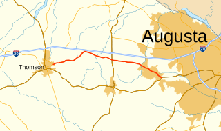
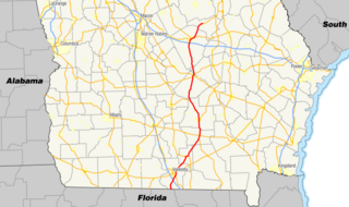
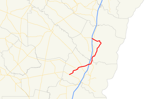
State Route 223 (SR 223) is a 20.9-mile-long (33.6 km) east–west state highway in the east-central part of the U.S. state of Georgia. Its routing travels through portions of McDuffie, Columbia, and Richmond counties. The highway connects Thomson with Grovetown, Augusta, and Fort Gordon. Except for the portions in Thomson, Grovetown, and Augusta, the highway is relatively rural.

References

  1. 1 2 Google (November 2, 2013). "Route of SR 356" (Map). Google Maps . Google. Retrieved November 2, 2013.
  2. 1 2 3 Georgia State Highway System (PDF) (Map). Cartography by GSHD. Georgia State Highway Department. June 1, 1963. Retrieved August 16, 2015.
  3. 1 2 Georgia State Highway System (PDF) (Map). Cartography by GSHD. Georgia State Highway Department. January 1, 1966. Retrieved August 16, 2015.
  4. "National Highway System: Georgia" (PDF). Federal Highway Administration. October 1, 2012. Retrieved October 19, 2013.
  5. Georgia State Highway System (PDF) (Map). Cartography by GSHD. Georgia State Highway Department. June 1, 1960. Archived from the original (PDF) on December 22, 2015. Retrieved August 16, 2015.
  6. Georgia State Highway System (PDF) (Map). Cartography by GSHD. Georgia State Highway Department. January 1, 1972. Retrieved August 16, 2015.
  7. Georgia State Highway System (PDF) (Map). Cartography by GSHD. Georgia State Highway Department. January 1, 1973. Retrieved August 16, 2015.
  8. Georgia State Highway System (PDF) (Map). Cartography by GSHD. Georgia State Highway Department. March 1, 1980. Retrieved August 16, 2015.
  9. Georgia State Highway System (PDF) (Map). Cartography by GSHD. Georgia State Highway Department. January 1, 1982. Retrieved August 16, 2015.

Route map: Google

KML file (edithelp)
KML is from Wikidata