In geology, felsic is a modifier describing igneous rocks that are relatively rich in elements that form feldspar and quartz. It is contrasted with mafic rocks, which are relatively richer in magnesium and iron. Felsic refers to silicate minerals, magma, and rocks which are enriched in the lighter elements such as silicon, oxygen, aluminium, sodium, and potassium. Felsic magma or lava is higher in viscosity than mafic magma/lava.
Geology is a branch of natural science concerned with Earth and other astronomical objects, the features or rocks of which it is composed, and the processes by which they change over time. Modern geology significantly overlaps all other Earth sciences, including hydrology, and so is treated as one major aspect of integrated Earth system science and planetary science.
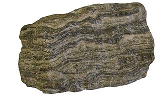
Gneiss is a common and widely distributed type of metamorphic rock. It is formed by high-temperature and high-pressure metamorphic processes acting on formations composed of igneous or sedimentary rocks. Gneiss forms at higher temperatures and pressures than schist. Gneiss nearly always shows a banded texture characterized by alternating darker and lighter colored bands and without a distinct cleavage.

Structural geology is the study of the three-dimensional distribution of rock units with respect to their deformational histories. The primary goal of structural geology is to use measurements of present-day rock geometries to uncover information about the history of deformation (strain) in the rocks, and ultimately, to understand the stress field that resulted in the observed strain and geometries. This understanding of the dynamics of the stress field can be linked to important events in the geologic past; a common goal is to understand the structural evolution of a particular area with respect to regionally widespread patterns of rock deformation due to plate tectonics.

A biotope is an area of uniform environmental conditions providing a living place for a specific assemblage of plants and animals. Biotope is almost synonymous with the term "habitat", which is more commonly used in English-speaking countries. However, in some countries these two terms are distinguished: the subject of a habitat is a population, the subject of a biotope is a biocoenosis or "biological community".

Soil science is the study of soil as a natural resource on the surface of the Earth including soil formation, classification and mapping; physical, chemical, biological, and fertility properties of soils; and these properties in relation to the use and management of soils.
Environmental geology, like hydrogeology, is an applied science concerned with the practical application of the principles of geology in the solving of environmental problems created by man. It is a multidisciplinary field that is closely related to engineering geology and, to a lesser extent, to environmental geography. Each of these fields involves the study of the interaction of humans with the geologic environment, including the biosphere, the lithosphere, the hydrosphere, and to some extent the atmosphere. In other words, environmental geology is the application of geological information to solve conflicts, minimizing possible adverse environmental degradation or maximizing possible advantageous conditions resulting from the use of natural and modified environment. With an increasing world population and industrialization, the natural environment and resources are under high strain which puts them at the forefront of world issues. Environmental geology is on the rise with these issues as solutions are found by utilizing it.

Geomorphology is the scientific study of the origin and evolution of topographic and bathymetric features created by physical, chemical or biological processes operating at or near Earth's surface. Geomorphologists seek to understand why landscapes look the way they do, to understand landform and terrain history and dynamics and to predict changes through a combination of field observations, physical experiments and numerical modeling. Geomorphologists work within disciplines such as physical geography, geology, geodesy, engineering geology, archaeology, climatology, and geotechnical engineering. This broad base of interests contributes to many research styles and interests within the field.

In geology, rock is any naturally occurring solid mass or aggregate of minerals or mineraloid matter. It is categorized by the minerals included, its chemical composition, and the way in which it is formed. Rocks form the Earth's outer solid layer, the crust, and most of its interior, except for the liquid outer core and pockets of magma in the asthenosphere. The study of rocks involves multiple subdisciplines of geology, including petrology and mineralogy. It may be limited to rocks found on Earth, or it may include planetary geology that studies the rocks of other celestial objects.

Palynology is the "study of dust" or of "particles that are strewn". A classic palynologist analyses particulate samples collected from the air, from water, or from deposits including sediments of any age. The condition and identification of those particles, organic and inorganic, give the palynologist clues to the life, environment, and energetic conditions that produced them.

A geode is a geological secondary formation within sedimentary and volcanic rocks. Geodes are hollow, vaguely spherical rocks, in which masses of mineral matter are secluded. The crystals are formed by the filling of vesicles in volcanic and subvolcanic rocks by minerals deposited from hydrothermal fluids; or by the dissolution of syn-genetic concretions and partial filling by the same or other minerals precipitated from water, groundwater, or hydrothermal fluids.

A phenocryst is an early forming, relatively large and usually conspicuous crystal distinctly larger than the grains of the rock groundmass of an igneous rock. Such rocks that have a distinct difference in the size of the crystals are called porphyries, and the adjective porphyritic is used to describe them. Phenocrysts often have euhedral forms, either due to early growth within a magma, or by post-emplacement recrystallization. Normally the term phenocryst is not used unless the crystals are directly observable, which is sometimes stated as greater than .5 millimeter in diameter. Phenocrysts below this level, but still larger than the groundmass crystals, are termed microphenocrysts. Very large phenocrysts are termed megaphenocrysts. Some rocks contain both microphenocrysts and megaphenocrysts. In metamorphic rocks, crystals similar to phenocrysts are called porphyroblasts.

A geopark is a protected area with internationally significant geology within which sustainable development is sought and which includes tourism, conservation, education and research concerning not just geology but other relevant sciences.

Geodiversity is the variety of earth materials, forms and processes that constitute and shape the Earth, either the whole or a specific part of it. Relevant materials include minerals, rocks, sediments, fossils, soils and water. Forms may comprise folds, faults, landforms and other expressions of morphology or relations between units of earth material. Any natural process that continues to act upon, maintain or modify either material or form represents another aspect of geodiversity. However geodiversity is not normally defined to include the likes of landscaping, concrete or other significant human influence.
Geotourism is tourism associated with geological attractions and destinations. Geotourism deals with the abiotic natural and built environments. Geotourism was first defined in England by Thomas Alfred Hose in 1995.

Geodynamics is a subfield of geophysics dealing with dynamics of the Earth. It applies physics, chemistry and mathematics to the understanding of how mantle convection leads to plate tectonics and geologic phenomena such as seafloor spreading, mountain building, volcanoes, earthquakes, faulting. It also attempts to probe the internal activity by measuring magnetic fields, gravity, and seismic waves, as well as the mineralogy of rocks and their isotopic composition. Methods of geodynamics are also applied to exploration of other planets.
Physiotope is the total abiotic matrix of habitat present within any certain ecotope. The physiotope is the landform, the rocks and the soils, the climate and the hydrology, and the geologic processes which marshalled all these resources together in a certain way and in this time and place.
Physiographic regions of the world are a means of defining Earth's landforms into distinct regions, based upon the classic three-tiered approach by Nevin M. Fenneman in 1916, that separates landforms into physiographic divisions, physiographic provinces, and physiographic sections. Originally used in North America, the model became the basis for similar classifications of other continents, and was still considered valid as of 1951.

Igneous rock, or magmatic rock, is one of the three main rock types, the others being sedimentary and metamorphic. Igneous rock is formed through the cooling and solidification of magma or lava.
Geoheritage is the geological aspect of natural and cultural heritage. A geosite is a particular geoheritage asset.
