External links
- Map sources for Gilroyd
Coordinates: 53°32′13″N1°30′40″W / 53.53705°N 1.51110°W
| | This South Yorkshire location article is a stub. You can help Wikipedia by expanding it. |
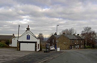
Gilroyd is a village in the Metropolitan Borough of Barnsley in South Yorkshire, England. The village falls within the Dodworth ward of Barnsley MBC.
Coordinates: 53°32′13″N1°30′40″W / 53.53705°N 1.51110°W
| | This South Yorkshire location article is a stub. You can help Wikipedia by expanding it. |
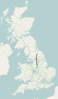
The A61 is a major trunk road in England connecting Derby and Thirsk in North Yorkshire by way of Alfreton, Clay Cross, Chesterfield, Sheffield, Barnsley, Wakefield, Leeds, Harrogate and Ripon. The road is closely paralleled by the M1 motorway between Derby and Leeds.

Darton is a large village in the Metropolitan Borough of Barnsley, on the border with West Yorkshire, England. At the time of the 2001 UK census, it had a population of 14,927, increasing to 21,345 for both Darton Wards at the 2011 Census.
The Metropolitan Borough of Barnsley is a metropolitan borough in South Yorkshire, England; the main settlement is Barnsley and other notable towns include Penistone, Wombwell and Hoyland.

Shafton is a civil parish in the Metropolitan Borough of Barnsley in South Yorkshire, England, on the border with West Yorkshire. At the 2001 census it had a population of 2,840, increasing to 3,447 at the 2011 Census. The parish contains the villages of Shafton and Shafton Two Gates.

Staincross is a village in South Yorkshire, England, on the border with West Yorkshire. Historically part of the West Riding of Yorkshire, it formed part of the defunct Barnsley West and Penistone borough constituency, following the Boundary Commission for England's report on South Yorkshire's Parliamentary constituencies in 2004 and the subsequent inquiry in 2005, it is now part of the Barnsley Central borough constituency. The population now falls within the Darton East ward of the Metropolitan Borough of Barnsley. The village also gave its name to the Staincross wapentake in the West Riding of Yorkshire. It is situated about 3 miles (4.8 km) from Barnsley, and 8 miles (13 km) from Wakefield.

High Hoyland is a village and civil parish in the Metropolitan Borough of Barnsley in South Yorkshire, England, on the border with West Yorkshire. It lies to the west of Kexbrough, and is located at approximately 53°35′10″N1°35′30″W, at an elevation of around 200 metres above sea level. At the 2001 census it had a population of 142, reducing to 128 at the 2011 Census.

Mapplewell is a village within the Metropolitan Borough of Barnsley, in South Yorkshire, England. Formerly part of the now defunct Barnsley West and Penistone borough constituency, following the Boundary Commission for England's report on South Yorkshire's Parliamentary constituencies in 2004 and the subsequent inquiry in 2005, it is now part of the Barnsley Central borough constituency. The village currently falls within the Barnsley MBC ward of Darton East.
Wilthorpe is an area of Barnsley in South Yorkshire, England.

Barnsley West and Penistone was a parliamentary constituency in South Yorkshire which returned one Member of Parliament (MP) to the House of Commons of the Parliament of the United Kingdom, elected by the first-past-the-post voting system.

Skidby is a small village and civil parish in Yorkshire Wolds of the East Riding of Yorkshire, England. It is situated about 6 miles (10 km) north-west of Hull city centre, 2.2 miles (3.5 km) west of Cottingham and 5 miles (8 km) south of Beverley.

Barnsdale, or Barnsdale Forest, is an area of South and West Yorkshire, England. The area falls within the modern-day districts of Doncaster and Wakefield. Barnsdale was historically part of the West Riding of Yorkshire. Barnsdale lies in the immediate vicinity north and northwest of Doncaster, and which was formerly forested and a place of royal hunts, and also renowned as a haunt of the outlaw Robin Hood in early ballads.

Elsecar Heritage Centre is a living history centre in Elsecar, Barnsley, England. It covers the industrial history of the area, and includes a Newcomen steam engine, the only such engine still in its original location.
The Barnsley and District Electric Traction Co was an electric tramway network serving the town of Barnsley, South Yorkshire.

Millhouse Green is a village on the north banks of the River Don on the A628 road west of Penistone in the English county of South Yorkshire.
The Barnsley Metrodome is a sports and leisure facility that was opened in 1989 by Neil Kinnock.
The Elsecar Collieries were the coal mines sunk in and around Elsecar, a small village to the south of Barnsley in what is now South Yorkshire, but was traditionally in the West Riding of Yorkshire.
Hoylandswaine is a village in the Metropolitan Borough of Barnsley, South Yorkshire, England.

Thorpe-in-Balne railway station was an unopened railway station on the Hull and Barnsley and Great Central Joint Railway. It was situated about 1 mile (1.6 km) from the village of Thorpe in Balne, South Yorkshire, England adjacent to the road and some 6 miles (10 km) north of Doncaster.
Sykehouse railway station was a station on the Hull and Barnsley and Great Central Joint Railway between Thorpe-in-Balne and Snaith and Pollington. It was built with the line which opened on 1 May 1916, but the station never opened to passengers. Like most stations on this line, it was situated on the edge of Sykehouse some distance from the village centre, in the hamlet of Topham, just south of where the railway crossed the River Went. Despite never opening to passengers, the station had the necessary facilities, and the two flanking platforms remained in situ until 1960.

The Selby–Goole line was a standard gauge branch line connecting Selby and Goole, built in 1910 by the North Eastern Railway. The line closed in the 1960s as part of the Beeching cuts.