
Knoydart is a peninsula in Lochaber, Highland, on the west coast of Scotland. Knoydart is sandwiched between Lochs Nevis and Hourn — often translated as "Loch Heaven" and "Loch Hell" respectively, although the somewhat poetic nature of these derivations is disputed. Forming the northern part of what is traditionally known as na Garbh-Chrìochan or "the Rough Bounds", because of its harsh terrain and remoteness, Knoydart is also referred to as "Britain's last wilderness". It is only accessible by boat, or by a 16-mile (26 km) walk through rough country, and the seven miles (11 km) of tarred road are not connected to the UK road system.

Ross is a region of Scotland. One of the provinces of Scotland from the 9th century, it gave its name to a later earldom and to the counties of Ross-shire and, later, Ross and Cromarty. The name Ross allegedly derives from a Gaelic word meaning "headland", perhaps a reference to the Black Isle. Another possible origin is the West Norse word for Orkney – Hrossey – meaning horse island; the area once belonged to the Norwegian earldom of Orkney. Ross is a historical comital region, perhaps predating the Mormaerdom of Ross. It is also a region used by the Church, with the Presbytery of Ross being part of the Synod of Ross, Sutherland and Caithness.
Strontian is the main village in Sunart, an area in western Lochaber, Highland, Scotland, on the A861 road. Prior to 1975 it was part of Argyllshire. It lies on the north shore of Loch Sunart, close to the head of the loch. In the hills to the north of Strontian lead was mined in the 18th century and in these mines the mineral strontianite was discovered, from which the element strontium was first isolated.
Torsa is one of the Slate Islands in Argyll and Bute, Scotland. Lying east of Luing and south of Seil, this tidal island was inhabited until the 1960s. There is now only one house there, which is used for holiday lets. The underlying bedrock is slate but unlike Torsa's immediate island neighbours this has never been worked commercially. The island's name is of Norse origin but the most prominent historical structure on the island is the ruined Caisteal nan Con on the northeast shore, once held by Clan Campbell. The abundant sea life in the waters surrounding the island are protected by the Loch Sunart to the Sound of Jura Marine Protected Area.

Glen Affric is a glen south-west of the village of Cannich in the Highland region of Scotland, some 15 miles west of Loch Ness. The River Affric runs along its length, passing through Loch Affric and Loch Beinn a' Mheadhoin. A minor public road reaches as far as the end of Loch Beinn a' Mheadhoin, but beyond that point only rough tracks and footpaths continue along the glen.

Auchlyne is a small hamlet in Stirling, Scotland. It is located approximately five miles west of Killin on Loch Tay, off the main A85 road that runs from Perth to Oban.

Morvern, historically also spelt Morven, is a peninsula and traditional district in the Highlands, on the west coast of Scotland. It lies south of the districts of Ardgour and Sunart, and is bounded on the north by Loch Sunart and Glen Tarbert, on the south east by Loch Linnhe and on the south west by the Sound of Mull. The name is derived from the Gaelic A' Mhorbhairne. The highest point is the summit of the Corbett Creach Bheinn which reaches 853 metres (2,799 ft) in elevation.
Pioneers Park Nature Center, established in 1963, is a 668-acre (2.70 km2) nature preserve located at the intersections of South Coddington and West Van Dorn Streets in Lincoln, Nebraska and is operated by the Lincoln Parks and Recreation Department.
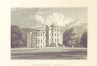
Airthrey Castle is a historic building and estate which now forms part of the buildings and grounds of the University of Stirling in central Scotland. The 18th-century building with 19th-century additions occupies a beautiful setting in landscaped grounds in the southern edge of the Ochil Hills, above the Forth valley. It is located close to Bridge of Allan, 2 miles from the historic city of Stirling.

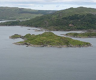
Carna or Càrna is an island in Loch Sunart, an arm of the sea, close to the Ardnamurchan peninsula, on the west coast of Scotland.

Arden is a historic estate outside Harriman, New York, that was owned by railroad magnate Edward Henry Harriman and his wife, Mary Averell Harriman. By the early 1900s, the family owned 40,000 acres in the area, half of it comprising the Arden Estate. The main house is at the top of a mountain east of the village, reachable by Arden House Road from NY 17. Since 2011, it has been owned by the nonprofit Research Center on Natural Conservation, which operates Arden House as a conference center with 97 guest rooms.

Achentoul is a hamlet in the Kinbrace area of Sutherland, in the Scottish council area of Highland. Consisting of a few farmhouses and barns, Achentoul lies around 1.5 miles (2.4 km) north of Kinbrace along the A897 road and south of Loch An Ruathair. Although the Achentoul Forest is located in this area, the landscape is said to be dominated by moist Atlantic heather moor.

Barrells Hall is a large house in the Warwickshire countryside near Henley-in-Arden. The nearest village is Ullenhall, which for many years was the estate village, large parts of it having been built by the owners of Barrells Hall, the Newtons, one of the families who formerly owned Barrells. An adjacent house named Barrells Park was built in about 1950 on part of the Barrells estate.
Thomas Henry Goodwin Newton (1835–1907) was the chairman of Imperial Continental Gas Association, one of the United Kingdom's largest energy businesses. He used "Goodwin" as his main christian name, which became a family middle name for generations afterwards.

Glensanda was a Viking settlement at the mouth of Glen Sanda on the Morvern peninsula within south west Lochaber, overlooking the island of Lismore and Loch Linnhe in the western Highlands of Scotland.
South Stoneham was a manor in South Stoneham parish. It was also a hundred, Poor law union, sanitary district then rural district covering a larger area of south Hampshire, England close to Southampton.
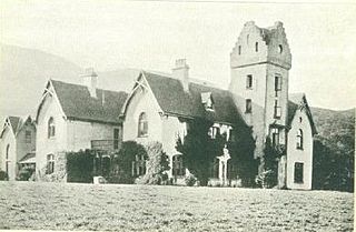
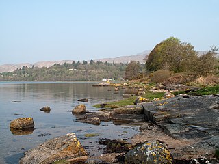
Glencripesdale House, or Glencripesdale Castle as it was sometimes referred to, was the centre of the 26,000-acre (11,000-hectare) Glencripesdale Estate, and was situated along the south side of Loch Sunart, a sea loch in the west highlands of Scotland.

Corrour Lodge is situated at the eastern end of Loch Ossian on the Corrour Estate on Rannoch Moor, Scotland. It is a large modernist residence which opened in 2004 in place of Old Corrour Lodge, which had been destroyed by fire in 1942. The previous lodge had been built in 1896 for John Stirling-Maxwell when he purchased the estate. Earlier still a building now referred to as Corrour Old Lodge had been the estate house and was some three miles to the south. The location is very remote – the entrance drive from the nearest public road is eleven miles long. However Corrour railway station is only about four miles away.
Whateley Hall was a stately home in the Warwickshire countryside near Castle Bromwich.
Risga is an uninhabited island in between Càrna and Oronsay, in the centre of Loch Sunart, about 800 yards (730 m) from the north shore, in the council area of Highland, Scotland. Its area is 12 hectares and its highest elevation is 43 metres (141 ft). In 1950, over 50 pairs of Lesser black-backed gull were recorded. The island is included in the grounds of Glenborrodale Castle and is part of Sunart SSSI. Ross Rock is located about 200 yards (180 m) from Risga. Risga has at least 60 crotagans along the east coast, used for fishing. Risga is a rocky island.
