Glenmore Bay

Last updated

Glenmore Bay

Glenmore Bay, Loch Sunart - geograph.org.uk - 56405.jpg

Glenmore Bay, Loch Sunart. From the road near Glenborrodale.
Location Loch Sunart
Ardnamurchan, Scotland
Coordinates 56°41′2.040″N5°56′10.344″W / 56.68390000°N 5.93620667°W / 56.68390000; -5.93620667 Coordinates: 56°41′2.040″N5°56′10.344″W / 56.68390000°N 5.93620667°W / 56.68390000; -5.93620667
River sources Glenmore River
Ocean/sea sources Atlantic Ocean
Basin  countries Scotland
Max. length 0.72 km (0.45 mi)
Max. width 0.6 km (0.37 mi)
Islands Eilean Mòr
Settlements Glenmore

Glenmore Bay is a remote tidal, 150° orientated,coastal embayment, located on the southern coastline of the west to east orientated Ardnamurchan peninsula, at the head of the sea loch Loch Sunart [1] [2]

Bay A recessed, coastal body of water connected to an ocean or lake

A bay is a recessed, coastal body of water that directly connects to a larger main body of water, such as an ocean, a lake, or another bay. A large bay is usually called a gulf, sea, sound, or bight. A cove is a type of smaller bay with a circular inlet and narrow entrance. A fjord is a particularly steep bay shaped by glacial activity.

Ardnamurchan peninsula in Lochaber, Scotland

Ardnamurchan is a 50-square-mile (130 km2) peninsula in the ward management area of Lochaber, Highland, Scotland, noted for being very unspoiled and undisturbed. Its remoteness is accentuated by the main access route being a single track road for much of its length. The most westerly point of mainland Great Britain, Corrachadh Mòr, is in Ardnamurchan.

Loch Sunart lake in the United Kingdom

Loch Sunart is a sea loch on the west coast of Scotland. Loch Sunart is bounded to the north by the Sunart district of Ardnamurchan and to the south by the Morvern district.

Contents

Settlements

Glenmore Bay has small settlement at the head of the bay, and includes the Ardnamurchan Natural History and Visitor Centre, which is a popular tourist destination. [3] The tiny settlement of Glenbeg is east of the village. The minor single lane with passing places, B Road: B8007 provides access to the bay, and connects to the main A861 at Salen 9 miles to the east, passing the villages of Glenborrodale, Laga and Salen, as it passes the beautiful curves of Loch Sunart.

A861 road road in Scotland

The A861 road is a circuitous, primarily coastal, road in Highland, Scotland.

Salen, Ardnamurchan village on the Ardnamurchan peninsula, Highland, Scotland

Salen is a coastal village on the Ardnamurchan peninsula, overlooking Salen Bay which is an inlet of the sea loch, Loch Sunart. Located in the Scottish council area of Highland, it is on the road to Ardnamurchan Point, the most westerly point of mainland Britain.

Glenborrodale human settlement in United Kingdom

Glenborrodale is a coastal community on Loch Sunart in the south of the Ardnamurchan peninsula in the Highland area of Scotland.

Geography

Glenmore Bay is one of a series of four bays, which are on the same chord of 2.78 km, which are bounded on the bulk of the Glenborrodale nature reserve in the east and the Ardslignish peninsula on the west. Glenmore Bay is at the far eastern end of the Chord, followed by Port na Croisg to the west, followed by Camas Fearna to the final small bay, Camas Bàn before the Ardslignish peninsula. Glenmore Bay is separated from Port na Croisg, by the sometimes island of Eilean Mòr, which is separated from the land by a tidal river, and at times, a small peninsula. Glenmore Bay is a tidal bay with a long shore of machair and sea-grasses as the land meets the bay proper.

Chord (geometry) geometric line segment whose endpoints both lie on the circle

A chord of a circle is a straight line segment whose endpoints both lie on the circle. A secant line, or just secant, is the infinite line extension of a chord. More generally, a chord is a line segment joining two points on any curve, for instance an ellipse. A chord that passes through a circle's center point is the circle's diameter. Every diameter is a chord, but not every chord is a diameter.

Machair A fertile low-lying grassy plain

Machair refers to a fertile low-lying grassy plain found on part of the northwest coastlines of Ireland and Scotland, in particular the Outer Hebrides. The best examples are to be found on North and South Uist, Harris and Lewis.

Related Research Articles

Kilchoan village in the United Kingdom

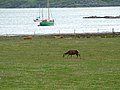
Kilchoan is a village on the Scottish peninsula of Ardnamurchan, in Lochaber, Highland. It is the most westerly village in Great Britain, although several tiny hamlets lie further west on the peninsula. The western linear, coastal parts of the village are Ormsaigmore and Ormsaigbeg.

Loch Shiel freshwater loch in Scotland

Loch Shiel is a freshwater loch situated 20 kilometres (12 mi) west of Fort William in the Highland council area of Scotland. At 28-kilometre-long it is the 4th longest loch in Scotland, and is the longest to have retained a natural outflow without any regulation of its water level, being 120 m (393 ft) deep. Its nature changes considerably along its length, being deep and enclosed by mountains in the north east and shallow surrounded by bog and rough pasture in the south west, from which end the 4 km River Shiel drains to the sea in Loch Moidart near Castle Tioram.

Acharacle human settlement in United Kingdom

Acharacle is a village in Ardnamurchan, Lochaber, within the county of Argyll. It is in the Highland Council area of Scotland

Sunart

Sunart is a rural district and community in the south west of Lochaber in Highland, Scotland, on the shores of Loch Sunart, and part of the civil parish of Ardnamurchan. The main village is Strontian, at the head of the loch, which is the location of Ardnamurchan High School, the local fire station, police station and other facilities.

Morvern

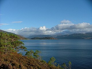
Morvern, historically also spelt Morven, is a peninsula and traditional district in the Highlands, on the west coast of Scotland. It lies south of the districts of Ardgour and Sunart, and is bounded on the north by Loch Sunart and Glen Tarbert, on the south east by Loch Linnhe and on the south west by the Sound of Mull. The name is derived from the Gaelic A' Mhorbhairne. The highest point is the summit of the Corbett Creach Bheinn which reaches 853 metres (2,799 ft) in elevation.

Loch Dùghaill lake in the United Kingdom

Loch Dùghaill is a freshwater tidal loch on the River Carron in Wester Ross, Scotland. The A890 road and the Kyle of Lochalsh Line a branch of the Highland railway both run along its northwest shore. Loch Carron is located 8 km downriver.

Càrna island in United Kingdom

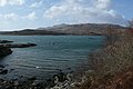
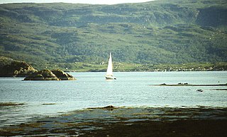
Càrna is an island in Loch Sunart, an arm of the sea, close to the Ardnamurchan peninsula, on the west coast of Scotland.

Kentra Bay coastal embayment located on the northern shore of the Ardnamurchan peninsula in Scotland

Kentra Bay, also known as the Singing Sands, is remote tidal, 306° orientated, coastal embayment located on the northern shore of the Ardnamurchan peninsula, at the extreme eastern side, where it meets the mainland proper, near Acharacle, in western Scottish Highlands of Scotland. Kentra Bay contains a large expanse of mudflat at low tide and small fragments of salt marsh, sand dune and machair. Kentra Bay is an inland bay, separated from the sea via a channel, at the north-east side.

Eilean Mòr, Loch Sunart An uninhabited, tidal island opposite Oronsay at the entrance to Loch Sunart on the west coast of Scotland

Eilean Mòr is an uninhabited, tidal island opposite Oronsay at the entrance to Loch Sunart, an arm of the sea on the west coast of Scotland. At low tide it is attached to Glenmore on the Ardnamurchan peninsula. The highest elevation is 123 feet (37 m). At low tide it is attached to Glenmore on the Ardnamurchan peninsula. The water around Eilean Mòr contains flame shells.

Enard Bay

Enard Bay is a large remote tidal coastal embayment, located 10.5 miles northwest of Ullapool, in northwestern Ross and Cromarty, Scottish Highlands in the west coast of Scotland. The mouth of the bay is about 4.5 miles across running from the head of Rubha Mòr peninsula at Rubna Na CòiGeach point to Rubna Na Brèige to the east.

Kames Bay, Loch Melfort

Kames Bay is small remote tidal north by northwest facing coastal embayment forming part of the southern coast of Loch Melfort within Argyll and Bute, Scotland.

Glenborrodale Bay bay in the United Kingdom

Glenborrodale Bay is a remote tidal, 200° orientated, coastal embayment, located on the southern coastline of the west to east orientated Ardnamurchan peninsula, at the head of the sea loch Loch Sunart in western Scottish Highlands of Scotland. To the west is the large Ardgour peninsula, of which the Ardnamurchan and the larger Morven peninsula to the south is part of.

Balmacara Bay

Balmacara Bay is a remote wide mouthed embayment on a 193° orientation, located on the north shore of the Lochalsh peninsula, on the north coast of sea loch of Loch Alsh and is situated next to the scattered village of Balmacara in the Scottish Highlands in the west coast of Scotland.

Loch Kirkaig

Loch Kirkaig is a small tidal sea loch, located in the region and parish of Assynt in south-west of Sutherland, in the west coast of Scotland and in the Scottish Highlands. Loch Kirkaig is 1.25 miles south of Loch Inver. The scattered crofting township of Inverkirkaig is located at the headland of the bay, next to the pebbly beach, on the round bay, which has no known name. The name Kirgaig comes from old Norse, Kirkju-vik meaning church bay, perhaps suggesting that in Viking times, there was a church, with a village located in the bay.

Sandaig Bay

Sandaig Bay is a coastal embayment, on a chord of 1.27 miles, on a 194° orientation, located on the north western end of the sea loch, Loch Nevis, facing the Sound of Sleat. The bay is within the western end of the Knoydart peninsula, in the Lochaber district in the historical county of Inverness-shire on the north west coast of Scotland.

Inninmore Bay

Inninmore Bay is a small shallow coastal embayment, on a chord of 1.74 miles, on a 215° orientation, in the Morvern peninsula in Lochaber, in the western coast of Scotland, and is some three miles east-south-east of the entrance to Loch Aline.

References

  1. "Scottish anchorages Glenmore Bay". Scottish anchorages. Retrieved 1 September 2017.
  2. Microsoft; Nokia (1 September 2017). "Glenmore Bay" (Map). Bing Maps . Microsoft. Retrieved 1 September 2017.
  3. Pollock, Vicky; Pollock, Richard. "Welcome to Ardnamurchan Natural History Visitor Centre". Ardnamurchan Natural History and Visitor Centre. Retrieved 16 September 2017.