
Lake Michigan is one of the five Great Lakes of North America. It is the second-largest of the Great Lakes by volume and the third-largest by surface area, after Lake Superior and Lake Huron. To the east, its basin is conjoined with that of Lake Huron through the 3+1⁄2-mile (5.6-kilometre) wide, 295-foot deep, Straits of Mackinac, giving it the same surface elevation as its easterly counterpart; the two are technically a single lake.

Lake Superior is the largest freshwater lake in the world by surface area and the third-largest by volume, holding 10% of the world's surface fresh water. Located in central North America, it is the northernmost and westernmost of the Great Lakes of North America, straddling the Canada–United States border with the Canadian province of Ontario to the north and east and the U.S. states of Minnesota to the west and Wisconsin and Michigan to the south. It drains into Lake Huron via St. Marys River, then through the lower Great Lakes to the St. Lawrence River and ultimately the Atlantic Ocean.

A biogeochemical cycle, or more generally a cycle of matter, is the movement and transformation of chemical elements and compounds between living organisms, the atmosphere, and the Earth's crust. Major biogeochemical cycles include the carbon cycle, the nitrogen cycle and the water cycle. In each cycle, the chemical element or molecule is transformed and cycled by living organisms and through various geological forms and reservoirs, including the atmosphere, the soil and the oceans. It can be thought of as the pathway by which a chemical substance cycles the biotic compartment and the abiotic compartments of Earth. The biotic compartment is the biosphere and the abiotic compartments are the atmosphere, lithosphere and hydrosphere.

The Truckee River is a river in the U.S. states of California and Nevada. The river flows northeasterly and is 121 miles (195 km) long. The Truckee is the sole outlet of Lake Tahoe and drains part of the high Sierra Nevada, emptying into Pyramid Lake in the Great Basin. Its waters are an important source of irrigation along its valley and adjacent valleys.
The Menominee River is a river in northwestern Michigan and northeastern Wisconsin in the United States. It is approximately 116 miles (187 km) long, draining a rural forested area of northern Wisconsin and the Upper Peninsula of Michigan into Lake Michigan. Its entire course, with that of its tributary, the Brule River, forms part of the boundary between the two states.

A kettle is a depression or hole in an outwash plain formed by retreating glaciers or draining floodwaters. The kettles are formed as a result of blocks of dead ice left behind by retreating glaciers, which become surrounded by sediment deposited by meltwater streams as there is increased friction. The ice becomes buried in the sediment and when the ice melts, a depression is left called a kettle hole, creating a dimpled appearance on the outwash plain. Lakes often fill these kettles; these are called kettle hole lakes. Another source is the sudden drainage of an ice-dammed lake. When the block melts, the hole it leaves behind is a kettle. As the ice melts, ramparts can form around the edge of the kettle hole. The lakes that fill these holes are seldom more than 10 m (33 ft) deep and eventually fill with sediment. In acid conditions, a kettle bog may form but in alkaline conditions, it will be kettle peatland.

The Driftless Area, also known as Bluff Country or the Blufflands, is a topographical and cultural region in the Midwestern United States that comprises southwestern Wisconsin, southeastern Minnesota, northeastern Iowa, and the extreme northwestern corner of Illinois.

Viral hemorrhagic septicemia (VHS) is a deadly infectious fish disease caused by Viral hemorrhagic septicemia virus. It afflicts over 50 species of freshwater and marine fish in several parts of the Northern Hemisphere. Different strains of the virus occur in different regions, and affect different species. There are no signs that the disease affects human health. VHS is also known as Egtved disease, and the virus as Egtved virus.

Lake Sunapee is located within Sullivan County and Merrimack County in western New Hampshire, the United States. It is the fifth-largest lake located entirely in New Hampshire.
A Blue Ribbon fishery is a designation made in the United States by government and other authorities to identify recreational fisheries of extremely high quality. Official Blue Ribbon status is generally based on a set of established criteria which typically addresses the following elements:
Criteria as used by Utah Division of Wildlife Resources. Specific criteria may vary by state.

The East Branch Penobscot River is a 75.3-mile-long (121.2 km) tributary of Maine's Penobscot River. It flows in Piscataquis County and Penobscot County.

Trout Bog Lake, also known as Bog 12-15, is a small bog lake in Vilas County, Wisconsin. It is located near the south basin of the much larger Trout Lake. The lake is entirely surrounded by vegetation, except for a logging road that provides access to it. Being a bog, the pH is extremely low; on average it is 4.8.

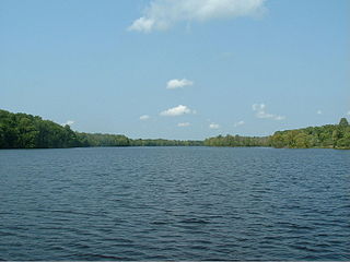
Trout Lake is in Vilas County, Wisconsin, near the towns of Boulder Junction and Arbor Vitae, Wisconsin. With a surface area of 6.208 sq mi (16.079 km2) and a volume of 0.058 cu mi (0.240 km3), Trout Lake is one of the largest lakes in Vilas County. It has 16.1 mi (25.9 km) of shoreline, a large portion of which is undeveloped. There are also seven islands within the lake: Miller Island, Zimmerman Island, Haunted Island, Easter Island, Fisk Island, Chocolate Drop Island, and an unnamed island. It is a dimictic oligotrophic lake that supports a large number of sport fish, which has made it a popular angling destination.

The Sunapee trout, also called blueback trout, Sunapee Golden trout, or Quebec red trout, is a putative subspecies of Arctic char native to northeastern New England in the United States, as well as Québec and New Brunswick in Canada, with introduced populations in Idaho.
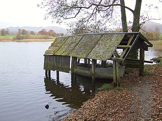
Blelham Tarn is a large valley tarn in the Lake District of England, to the north of the hill Latterbarrow. The settlements of Outgate, Low Wray and High Wray are close by. The tarn is drained to the northeast by the short Blelham Beck into Windermere. This beck was previously straightened and lowered. Fish species in the tarn include brown trout, eel, perch, pike and roach, much of the tarn shore is reedbed and waterfowl present can include great crested grebe, whooper swan and golden-eye.
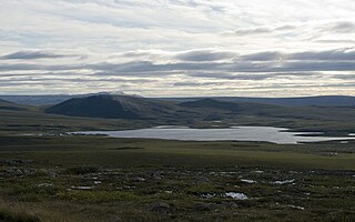
Toolik Lake is an Arctic lake located within the North Slope Borough, Alaska. It is in a remote wilderness area managed by the Bureau of Land Management accessed by the Dalton Highway. It is 130 mi (210 km) south of Prudhoe Bay in the northern foothills of the Brooks Range. The name is derived from the Iñupiat word tutlik, meaning yellow-billed loon.
Kathleen C. Weathers is an ecosystem scientist and the G. Evelyn Hutchinson Chair in Ecology at the Cary Institute of Ecosystem Studies. Her expertise focuses on understanding the ecology of air-land-water interactions. Weathers is the current elected President of the Ecological Society of America (2020-2021).

Paul and Peter are two connected lakes located in Michigan's upper peninsula near the Wisconsin border in Vilas County (WI) and Gogebic County (MI). Paul and Peter are kettle lakes, which is a type of lake formed by glaciers. Peter Lake is larger with an area of 6.24 acres and a maximum depth of 19.6 meters while Paul Lake has an area of 4.12 acres and a maximum depth of 15 meters. The lakes are a part of the University of Notre Dame Environmental Research Center (UNDERC). The lakes, bogs, streams, and marshes of the UNDERC are located within deciduous and coniferous forests. The surrounding forest is made up mostly of sugar maple, yellow birch, and balsam fir. The two lakes are ideal for performing whole lake experiments since one lake can receive treatments while the other can remain a control. No fishing is allowed making the two connected lakes ideal for studying their fish populations. The lakes' basins are also located within the UNDERC meaning that no outside interference can occur. The lakes are dimictic, freezing in November and mixing in the fall and again partially mixing in the spring.
