Gmina Szczuczyn

Last updated
Gmina Szczuczyn
Szczuczyn Commune
Gmina
POL Szczuczyn COA.svg
Coat of arms
POL powiat grajewski gmina Szczuczyn.svg
Gmina Szczuczyn within the Grajewo County
Coordinates(Szczuczyn): 53°33′58″N22°17′6″E / 53.56611°N 22.28500°E / 53.56611; 22.28500 Coordinates: 53°33′58″N22°17′6″E / 53.56611°N 22.28500°E / 53.56611; 22.28500
CountryFlag of Poland.svg  Poland
Voivodeship Podlaskie
County Grajewo
Seat Szczuczyn
Area
  Total 115.72 km2 (44.68 sq mi)
Population (2011 [1] )
  Total 6,485
  Density 56/km2 (150/sq mi)
   Urban 3,523
  Rural 2,962
Website http://www.um.szczuczyn.pl

Gmina Szczuczyn is an urban-rural gmina (administrative district) in Grajewo County, Podlaskie Voivodeship, in north-eastern Poland. Its seat is the town of Szczuczyn, which lies approximately 15 kilometres (9 mi) south-west of Grajewo and 77 km (48 mi) north-west of the regional capital Białystok.

Gmina administrative division of Poland

The gmina is the principal unit of the administrative division of Poland, similar to a municipality. As of 2010 there were 2,478 gminy throughout the country. The word gmina derives from the German word Gemeinde, meaning "community".

Grajewo County County in Podlaskie, Poland

Grajewo County is a unit of territorial administration and local government (powiat) in Podlaskie Voivodeship, north-eastern Poland. It came into being on January 1, 1999, as a result of the Polish local government reforms passed in 1998. Its administrative seat and largest town is Grajewo, which lies 76 kilometres (47 mi) north-west of the regional capital Białystok. The county also contains the towns of Szczuczyn, lying 15 km (9 mi) south-west of Grajewo, and Rajgród, 19 km (12 mi) north-east of Grajewo.

Podlaskie Voivodeship Voivodeship in Poland

Podlaskie Voivodeship or Podlasie Province is a voivodeship (province) in northeastern Poland. It borders on Masovian Voivodeship to the west, Warmian-Masurian Voivodeship to the northwest, Lublin Voivodeship to the south, the Belarusian Voblasts of Grodno and Brest to the east, the Lithuanian Counties of Alytus and Marijampolė to the northeast, and the Kaliningrad Oblast of Russia to the north.

Contents

The gmina covers an area of 115.72 square kilometres (44.7 sq mi), and as of 2006 its total population is 6,675 (out of which the population of Szczuczyn amounts to 3,564, and the population of the rural part of the gmina is 3,111).

Villages

Apart from the town of Szczuczyn, Gmina Szczuczyn contains the villages and settlements of Balcer, Bęćkowo, Brzeźno, Bzury, Chojnowo, Czarnówek, Czarnowo, Danowo, Dołęgi, Gutki, Jambrzyki, Koniecki Małe, Koniecki-Rostroszewo, Kurki, Lipnik, Mazewo, Miętusewo, Milewo, Niećkowo, Niedźwiadna, Niedźwiedzkie, Nowe Zacieczki, Obrytki, Przeszkoda, Rakowo, Skaje, Sokoły, Stare Guty, Świdry-Awissa, Tarachy, Wólka, Zacieczki, Załuski and Zofiówka.

Balcer is a village in the administrative district of Gmina Szczuczyn, within Grajewo County, Podlaskie Voivodeship, in north-eastern Poland.

Bęćkowo Village in Podlaskie, Poland

Bęćkowo is a village in the administrative district of Gmina Szczuczyn, within Grajewo County, Podlaskie Voivodeship, in north-eastern Poland. It lies approximately 5 kilometres (3 mi) north-east of Szczuczyn, 11 km (7 mi) south-west of Grajewo, and 79 km (49 mi) north-west of the regional capital Białystok.

Brzeźno, Podlaskie Voivodeship Village in Podlaskie, Poland

Brzeźno is a village in the administrative district of Gmina Szczuczyn, within Grajewo County, Podlaskie Voivodeship, in north-eastern Poland. It lies approximately 8 kilometres (5 mi) south-west of Szczuczyn, 22 km (14 mi) south-west of Grajewo, and 80 km (50 mi) north-west of the regional capital Białystok.

Neighbouring gminas

Gmina Szczuczyn is bordered by the gminas of Biała Piska, Grabowo, Grajewo, Prostki and Wąsosz.

Gmina Biała Piska is an urban-rural gmina in Pisz County, Warmian-Masurian Voivodeship, in northern Poland. Its seat is the town of Biała Piska, which lies approximately 18 kilometres (11 mi) east of Pisz and 105 km (65 mi) east of the regional capital Olsztyn.

Gmina Grabowo Gmina in Podlaskie, Poland

Gmina Grabowo is a rural gmina in Kolno County, Podlaskie Voivodeship, in north-eastern Poland. Its seat is the village of Grabowo, which lies approximately 15 kilometres (9 mi) east of Kolno and 78 km (48 mi) north-west of the regional capital Białystok.

Gmina Grajewo Gmina in Podlaskie, Poland

Gmina Grajewo is a rural gmina in Grajewo County, Podlaskie Voivodeship, in north-eastern Poland. Its seat is the town of Grajewo, although the town is not part of the territory of the gmina.

Related Research Articles

Gmina Rajgród Gmina in Podlaskie, Poland

Gmina Rajgród is an urban-rural gmina in Grajewo County, Podlaskie Voivodeship, in north-eastern Poland. Its seat is the town of Rajgród, which lies approximately 19 kilometres (12 mi) north-east of Grajewo and 75 km (47 mi) north-west of the regional capital Białystok.

Gmina Wąsosz, Podlaskie Voivodeship Gmina in Podlaskie, Poland

Gmina Wąsosz is a rural gmina in Grajewo County, Podlaskie Voivodeship, in north-eastern Poland. Its seat is the village of Wąsosz, which lies approximately 17 kilometres (11 mi) south-west of Grajewo and 73 km (45 mi) north-west of the regional capital Białystok.

Gmina Jedwabne Gmina in Podlaskie, Poland

Gmina Jedwabne is an urban-rural gmina in Łomża County, Podlaskie Voivodeship, in north-eastern Poland. Its seat is the town of Jedwabne, which lies approximately 20 kilometres (12 mi) north-east of Łomża and 61 km (38 mi) west of the regional capital Białystok.

Gmina Goniądz Gmina in Podlaskie, Poland

Gmina Goniądz is an urban-rural gmina in Mońki County, Podlaskie Voivodeship, in north-eastern Poland. Its seat is the town of Goniądz, which lies approximately 11 kilometres (7 mi) north-west of Mońki and 51 km (32 mi) north-west of the regional capital Białystok.

Gmina Prostki is a rural gmina in Ełk County, Warmian-Masurian Voivodeship, in northern Poland. Its seat is the village of Prostki, which lies approximately 15 kilometres (9 mi) south of Ełk and 128 km (80 mi) east of the regional capital Olsztyn.

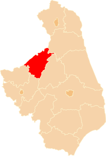
Gmina Szamotuły is an urban-rural gmina in Szamotuły County, Greater Poland Voivodeship, in west-central Poland. Its seat is the town of Szamotuły, which lies approximately 32 kilometres (20 mi) north-west of the regional capital Poznań.

Czarnówek Village in Podlaskie, Poland

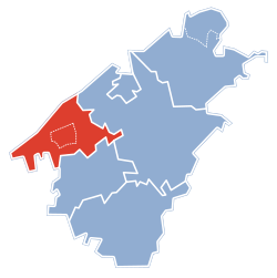
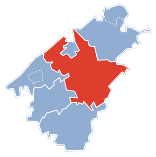
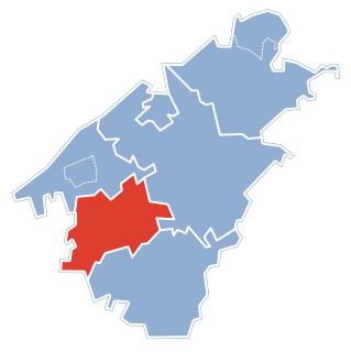
Czarnówek is a village in the administrative district of Gmina Szczuczyn, within Grajewo County, Podlaskie Voivodeship, in north-eastern Poland. It lies approximately 5 kilometres (3 mi) north-west of Szczuczyn, 18 km (11 mi) south-west of Grajewo, and 82 km (51 mi) north-west of the regional capital Białystok.

Czarnowo, Podlaskie Voivodeship Village in Podlaskie, Poland

Czarnowo is a village in the administrative district of Gmina Szczuczyn, within Grajewo County, Podlaskie Voivodeship, in north-eastern Poland. It lies approximately 5 kilometres (3 mi) west of Szczuczyn, 18 km (11 mi) south-west of Grajewo, and 81 km (50 mi) north-west of the regional capital Białystok.

Jambrzyki Village in Podlaskie, Poland

Jambrzyki is a village in the administrative district of Gmina Szczuczyn, within Grajewo County, Podlaskie Voivodeship, in north-eastern Poland. It lies approximately 3 kilometres (2 mi) west of Szczuczyn, 17 km (11 mi) south-west of Grajewo, and 79 km (49 mi) north-west of the regional capital Białystok.

Kurki, Gmina Szczuczyn Village in Podlaskie, Poland

Kurki is a village in the administrative district of Gmina Szczuczyn, within Grajewo County, Podlaskie Voivodeship, in north-eastern Poland. It lies approximately 9 kilometres (6 mi) west of Szczuczyn, 23 km (14 mi) south-west of Grajewo, and 83 km (52 mi) north-west of the regional capital Białystok.

Milewo, Grajewo County Village in Podlaskie, Poland

Milewo is a village in the administrative district of Gmina Szczuczyn, within Grajewo County, Podlaskie Voivodeship, in north-eastern Poland. It lies approximately 5 kilometres (3 mi) east of Szczuczyn, 12 km (7 mi) south-west of Grajewo, and 74 km (46 mi) north-west of the regional capital Białystok.

Niećkowo Village in Podlaskie, Poland

Niećkowo is a village in the administrative district of Gmina Szczuczyn, within Grajewo County, Podlaskie Voivodeship, in north-eastern Poland. It lies approximately 5 kilometres (3 mi) east of Szczuczyn, 13 km (8 mi) south-west of Grajewo, and 73 km (45 mi) north-west of the regional capital Białystok.

Nowe Zacieczki Village in Podlaskie, Poland

Nowe Zacieczki is a village in the administrative district of Gmina Szczuczyn, within Grajewo County, Podlaskie Voivodeship, in north-eastern Poland. It lies approximately 6 kilometres (4 mi) north of Szczuczyn, 12 km (7 mi) west of Grajewo, and 82 km (51 mi) north-west of the regional capital Białystok.

Skaje Village in Podlaskie, Poland

Skaje is a village in the administrative district of Gmina Szczuczyn, within Grajewo County, Podlaskie Voivodeship, in north-eastern Poland. It lies approximately 3 kilometres (2 mi) north-west of Szczuczyn, 15 km (9 mi) south-west of Grajewo, and 80 km (50 mi) north-west of the regional capital Białystok.

Świdry-Awissa Village in Podlaskie, Poland

Świdry-Awissa is a village in the administrative district of Gmina Szczuczyn, within Grajewo County, Podlaskie Voivodeship, in north-eastern Poland. It lies approximately 4 kilometres (2 mi) south of Szczuczyn, 17 km (11 mi) south-west of Grajewo, and 74 km (46 mi) north-west of the regional capital Białystok.

Zacieczki Village in Podlaskie, Poland

Zacieczki is a village in the administrative district of Gmina Szczuczyn, within Grajewo County, Podlaskie Voivodeship, in north-eastern Poland. It lies approximately 6 kilometres (4 mi) north of Szczuczyn, 12 km (7 mi) west of Grajewo, and 81 km (50 mi) north-west of the regional capital Białystok.

Załuski, Podlaskie Voivodeship Village in Podlaskie, Poland

Załuski is a village in the administrative district of Gmina Szczuczyn, within Grajewo County, Podlaskie Voivodeship, in north-eastern Poland. It lies approximately 5 kilometres (3 mi) west of Szczuczyn, 18 km (11 mi) south-west of Grajewo, and 81 km (50 mi) north-west of the regional capital Białystok.

References

  1. Demographic Yearbook of Poland 2012