
The Vladayska is a river in western Bulgaria, a tributary of the Perlovska.

Cherni Vrah is the summit of Vitosha Mountain in Bulgaria. Rising to 2290 m, the peak is the fourth highest mountain summit in the country after Musala, Vihren, and Botev Vrah.

Bistritsa is a large village in the Pancharevo municipality, located at 15 km to the south of the capital Sofia. As of 2006 it has 4,004 inhabitants.
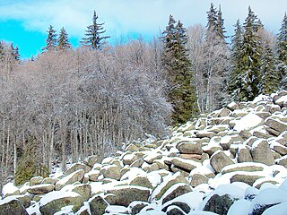
Zlatnite Mostove is the largest stone river on Vitosha Mountain, Bulgaria. The feature is situated in the valley of Vladayska River, extending 2.2 km, and up to 150 m wide, with several ‘tributary’ stone rivers. The stone river is ‘descending’ from elevation 1800 m above sea level in Boeritsa Chalet area to 1410 m at Zlatnite Mostove site. The lower extremity of the stone river is known as Zlatnite Mostove site, a popular tourist destination accessible from Sofia by road.
The Boyanska reka is a river in western Bulgaria, a left tributary to the river Perlovska.

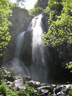
Bistritsa or Vitoshka Bistritsa, is a river in western Bulgaria, tributary of Iskar River. Flows from the eastern slopes of Golyam Rezen Peak on Vitosha Mountain, crossing Bistrishko Branishte Nature Reserve, where it forms a small but beautiful waterfall Samokovishteto, then crossing villages of Bistritsa and Pancharevo to flow into Lake Pancharevo, near Sofia. Additional charm of the area offer several artificial waterfalls in the lower reaches of the river.

Golyam Rezen is a peak on Vitosha Mountain in Bulgaria. Rising to 2,277 m, the peak is second to the mountain's summit Cherni Vrah situated 900 m to the west. Golyam Rezen hosts an Air Traffic Services facility, as well as military communications installations. The precipitous east slopes of the peak are a popular rock climbing site, overlooking Bistritsa River Valley in Bistrishko Branishte Biosphere Reserve.

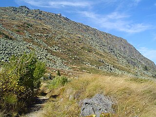
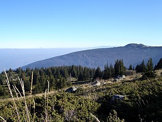
Kamen Del is a peak on Vitosha Mountain in Bulgaria. Rising to 1,862 metres (6,109 ft), and surmounting the city of Sofia, it is the most conspicuous peak seen from the Bulgarian capital. Its northern slope is partly covered by an extensive one by one km stone sea. A flat col links Kamen Del to Ushite Peak 1,960 metres (6,430 ft) to the south, hosting a small refuge on the track between Aleko and Zlatnite Mostove, the two most popular tourist sites on Vitosha.

Aleko is a site on Vitosha Mountain in Bulgaria situated at the northern foothills of Malak Rezen Peak (2191 m), in the watershed of Yanchevska River draining eastwards towards the village of Bistritsa, Sofia.
Bistrishko Branishte is a nature reserve on Vitosha Mountain in Bulgaria comprising the eastern slopes of Golyam Rezen (2277 m), Malak Rezen (2191 m) and Skoparnik (2226 m) Peaks, the northern slopes of Golyam Kupen Peak (1930 m), and the upper valleys of Vitoshka Bistritsa River and Yanchevska River. Surface area 1061.6 ha, elevation between 1430 and 2277 m.

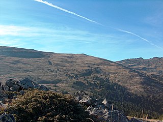
Selimitsa is a peak rising to 2,041 m west of Torfeno Branishte Nature Reserve in northwestern Vitosha Mountain in Bulgaria. The northern slopes of the peak are occupied by the ski runs of Konyarnika Ski Centre. Linked by tracks to Kumata Chalet and Zlatnite Mostove Tourist Centre to the north, Selimitsa Chalet, Kladnitsa Monastery and Kladnitsa Village to the west, Matnitsa River valley and Chuypetlovo Village to the south, and the mountain's summit Cherni Vrah to the east.

Torfeno Branishte is a nature reserve on Vitosha Mountain in Bulgaria, along with the Bistrishko Branishte reserve. The reserve has a surface area of 728.8 ha comprising the parts of Big Plateau and the Kapaklivets Plateau between the peaks of Cherni Vrah (2290 m), Ushite (1906 m), and Chernata Skala (1869 m), including the upper watersheds of the Vladayska, Boyanska and Dragalevska Rivers.

Malak Rezen is a peak rising to 2,191 m in northeastern Vitosha Mountain in Bulgaria. The peak is situated 1.5 km northeast of the summit Cherni Vrah, and 1.3 km north by east of Golyam Rezen Peak, surmounting Stenata ski run and Aleko site to the north.

Ushite Peak is a peak rising to 1,860 metres (6,100 ft) in northern Vitosha Mountain, Bulgaria. The peak is situated on the northern border of Torfeno Branishte Nature Reserve, and 650 m south of Kamen Del Peak. A small refuge is situated on the northeastern slopes Ushite, off track between Aleko and Zlatnite Mostove, the two most popular tourist sites on Vitosha.
Skoparnik is the third highest peak of Vitosha Mountain in Bulgaria. Rising to 2,226 m, the peak is situated 1.5 km south of Golyam Rezen Peak (2,277 m), and 2 km southeast of the summit Cherni Vrah (2,290 m). The peak is bounded by the Bistrishko Branishte Biosphere Reserve to the east, and a prohibited drinking water catchment area to the west, and is part of the divide between the Black Sea and the Mediterranean, with the Vitoshka Bistritsa draining its eastern slopes to flow into the Iskar River and eventually to the Danube River, and the Struma River draining the western slopes to flow into the Aegean Sea.
Golyam Kupen is a peak rising to 1,930 m in Vitosha Mountain, Bulgaria. The peak is situated on the southern border of Bistrishko Branishte Biosphere Reserve, on the watershed between Vitoshka Bistritsa to the north and Selska Reka to the south, rivers flowing eastwards to the villages of Bistritsa and Zheleznitsa respectively, and eventually to Iskar River.
The Dragalevska is a river in western Bulgaria, a tertiary tributary of the Iskar.
Sofia Capital Municipality is a obshtina (municipality) in Sofia City Province, Western Bulgaria.
It is named after its administrative centre - the city of Sofia, which is also the capital of Sofia City Province and Sofia Province and the capital of Bulgaria as well.


