Greater Rosario

Last updated

Greater Rosario
Towns and cities
Capitán Bermúdez City in Santa Fe, Argentina

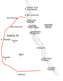
Capitán Bermúdez is a city in the province of Santa Fe, Argentina, located within the metropolitan area of Greater Rosario,, on the western shore of the Paraná River. It had a population of about 29,000 inhabitants at the time of the 2010 census [INDEC].

Fray Luis Beltrán, Santa Fe City in Santa Fe, Argentina

Fray Luis Beltrán is a small city in the province of Santa Fe, Argentina, located within the metropolitan area of Greater Rosario, north of the city of Rosario, on the western shore of the Paraná River. It had a population of about 15,000 inhabitants at the 2010 census [INDEC].

Funes, Santa Fe City in Santa Fe, Argentina

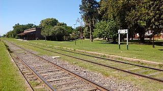
Funes is a small city in the province of Santa Fe, Argentina, located within the metropolitan area of Greater Rosario, about 15 km west from downtown Rosario. It has a population of about 23,500 inhabitants.

Rosario and its region from space. ISD highres ISS001 ISS001-390-4.JPG
Rosario and its region from space.

Greater Rosario is the metropolitan area of the city of Rosario, in the province of Santa Fe, Argentina. This metropolis has a population of about 1.3 million (1,276,000 million inhabitants) [1] thus being Argentina's third most populated urban settlement, after Buenos Aires and Córdoba. [2]

Metropolitan area region consisting of a densely populated urban core and its less-populated but economically-linked surroundings

A metropolitan area is a region consisting of a densely populated urban core and its less-populated surrounding territories, sharing industry, infrastructure, and housing. A metro area usually comprises multiple jurisdictions and municipalities: neighborhoods, townships, boroughs, cities, towns, exurbs, suburbs, counties, districts, states, and even nations like the eurodistricts. As social, economic and political institutions have changed, metropolitan areas have become key economic and political regions.

Rosario, Santa Fe City of Rosario in Santa Fe, Argentina

Rosario is the largest city in the central Argentina province of Santa Fe. The city is located 300 km (186 mi) northwest of Buenos Aires, on the west bank of the Paraná River. Rosario is the third most populous city in the country, and is also the most populous city in Argentina that is not a provincial capital. With a growing and important metropolitan area, Greater Rosario has an estimated population of 1,276,000 as of 2012. One of its main attractions includes the neoclassical architecture that has been retained over the centuries in hundreds of residences, houses and public buildings.

Provinces of Argentina Top level administrative division of Argentina 🇦🇷

Argentina is subdivided into twenty-three provinces and one autonomous city, Buenos Aires, which is the federal capital of the nation as decided by Congress. The provinces and the capital have their own constitutions, but exist under a federal system.

Contents

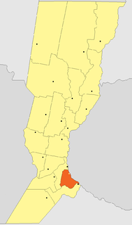
The Greater Rosario comprises Rosario itself (population about 910,000) and a large area around it, spreading in all directions except eastward (because of the Paraná River). Directly to the south it includes the city of Villa Gobernador Gálvez, with a population of about 75,000, at about 10 km (6.2 mi) from the center of Rosario.

Paraná River river in South America

The Paraná River is a river in south Central South America, running through Brazil, Paraguay, and Argentina for some 4,880 kilometres (3,030 mi). It is second in length only to the Amazon River among South American rivers. The name Paraná is an abbreviation of the phrase "para rehe onáva", which comes from the Tupi language and means "like the sea". It merges first with the Paraguay River and then farther downstream with the Uruguay River to form the Río de la Plata and empties into the Atlantic Ocean.

Villa Gobernador Gálvez City in Santa Fe, Argentina

Villa Gobernador Gálvez is a city in the province of Santa Fe, Argentina, located on the western ravine of the Paraná River, within the metropolitan area of Greater Rosario. It has 74,509 inhabitants per the 2001 census [INDEC]. It is separated from Rosario, to the north, by the Saladillo Stream. It is the fourth most populated city in the province and the second in the metropolitan area.

To the west and south-west there are several smaller towns and cities (Funes, Roldán, Pérez, Soldini); Roldán is 23 km from Rosario's center. These settlements were incorporated into the metropolis due to their vicinity to major roads leading into Rosario, and many people living there habitually commute to Rosario.

Roldán is a small city in the province of Santa Fe, Argentina, located within the metropolitan area of Greater Rosario. According to the 2001 census, it had a population of 11,470 inhabitants. Its area is 114 km².

Pérez, Santa Fe City in Santa Fe, Argentina

Pérez is a city in the province of Santa Fe, Argentina. It is part of the Greater Rosario metropolitan area, and lies 175 km south of the provincial capital. It has a population of about 26,000 inhabitants.

Soldini, Santa Fe Town in Santa Fe, Argentina

Soldini is a town (comuna) in the province of Santa Fe, Argentina. It is part of the Greater Rosario metropolitan area, and lies 127 km south from the provincial capital. It has a population of about 2,800 inhabitants.

The farthest end is to the north, following the coast of the river; from Rosario one finds, in succession and usually merging into each other, the towns of Granadero Baigorria, Capitán Bermúdez, Fray Luis Beltrán, San Lorenzo (already in a different departamento , with a population of over 40,000), and Puerto General San Martín, the last being at a distance of 35 km from Rosario.

Granadero Baigorria City in Santa Fe, Argentina

Granadero Baigorria is a city in the south of the province of Santa Fe, Argentina, located directly north of Rosario, on the western shore of the Paraná River, and forming part of the Greater Rosario metropolitan area. Its population is about 43,000 inhabitants (2015).

San Lorenzo, Santa Fe City in Santa Fe, Argentina

San Lorenzo is a city in the south of the province of Santa Fe, Argentina, located 23 km north of Rosario, on the western shore of the Paraná River, and forming one end of the Greater Rosario metropolitan area. It is the head town of the San Lorenzo Department, and it has about 46,000 inhabitants according to the 2010 census [INDEC].

Departments of Argentina

Departments form the second level of administrative division, and are subdivided in municipalities. They are extended in all of Argentina except for the Province of Buenos Aires and the Autonomous City of Buenos Aires, the national capital, each of which has different administrative arrangements.

The north of the Greater Rosario is one end of an area traditionally called Cordón Industrial ("Industrial Corridor"), since it was traditionally a heavily industrialized productive region. The prelude to the economic crisis in the 1990s largely dismantled the industrial infrastructure and damaged agricultural exports. As of 2006 the recovery of national economy has revitalized them, but high levels of poverty and unemployment persist (the last official survey indicates that 27.4% of the population is under the poverty line). [3]

The 1998–2002 Argentine Great Depression was an economic depression in Argentina, which began in the third quarter of 1998 and lasted until the second quarter of 2002. It followed the 1974–1990 Great Depression after a brief period of rapid economic growth.

Events in the year 2006 in Argentina.

Transportation

See also Transportation in Argentina.

The Greater Rosario has a fluid short-distance transportation scheme. Several of Rosario's urban bus lines cross the limits of the city into the neighboring towns (keeping the common urban fee), and many low-cost interurban short-distance lines depart at regular intervals from the Bus Terminal and the transport node at Plaza Sarmiento.

The metropolitan area is also a node of national and international transportation. Major roads and highways sprout from Rosario's Avenida de Circunvalación, originally a city-encircling two-way avenue. National Route 11 goes north through the towns already mentioned and towards the provincial capital, Santa Fe; the General Estanislao López Highway provides a faster direct path. To the south, National Route 9 crosses the provincial border and the Industrial Corridor continues up to San Nicolás de los Arroyos, province of Buenos Aires. Route 9 also runs west through Santa Fe and towards Córdoba. In addition, a national highway is being built, ultimately to reach the Córdoba City. To the east, the metropolis communicates with the neighboring Entre Ríos (and from there Uruguay and Brazil) through the Rosario-Victoria Bridge, opened in 2003.

Much of the agricultural exports of the north of Argentina go overseas through the ports of the Greater Rosario on the Paraná, the Port of Rosario and Puerto General San Martín being the most important ones.

Air traffic in the area is serviced by the Rosario International Airport ( IATA : ROS, ICAO : SAAR), located 13 km from the center and partly in lands of the city of Funes.

Related Research Articles

Transport in Argentina

Transport in Argentina is mainly based on a complex network of routes, crossed by relatively inexpensive long-distance buses and by cargo trucks. The country also has a number of national and international airports. The importance of the long-distance train is minor today, though in the past it was widely used and is now regaining momentum after the re-nationalisation of the country's commuter and freight networks. Fluvial transport is mostly used for cargo.

Córdoba, Argentina City in Córdoba, Argentina

Córdoba is a city in central Argentina, in the foothills of the Sierras Chicas on the Suquía River, about 700 km (435 mi) northwest of the Buenos Aires. It is the capital of Córdoba Province and the second most populous city in Argentina after Buenos Aires, with about 1.3 million inhabitants according to the 2010 census. It was founded on 6 July 1573 by Jerónimo Luis de Cabrera, who named it after Córdoba, Spain. It was one of the first Spanish colonial capitals of the region that is now Argentina. The National University of Córdoba is the oldest university of the country and the seventh to be inaugurated in Spanish America. It was founded in 1613 by the Jesuit Order. Because of this, Córdoba earned the nickname La Docta.

Santa Fe, Argentina City in Santa Fe, Argentina

Santa Fe de la Vera Cruz is the capital city of the province of Santa Fe, Argentina. It is situated in north-eastern Argentina, near the junction of the Paraná and Salado rivers. It lies 15 kilometres (9.3 mi) from the Hernandarias Subfluvial Tunnel that connects it to the city of Paraná. The city is also connected by canal with the port of Colastiné on the Paraná River. Santa Fe de la Vera Cruz has about 391,164 inhabitants as per the 2010 census [INDEC]. The metropolitan area has a population of 653,073, making it the eighth largest in Argentina. The third largest city in Argentina is Rosario, also located in Santa Fe Province. Rosario has a population of 1.24 million and it is the largest city in Argentina not to be a provincial capital.

Villa Constitución City in Santa Fe, Argentina

Villa Constitución is a city in the province of Santa Fe, Argentina, and the head town of the Constitución Department. It is located on the south-western banks of the Paraná River between the courses of the Arroyo Pavón and the Arroyo del Medio, about 214 km south from the provincial capital, the city of Santa Fe, and 50 km from Rosario. It has a population of more than 47,374 inhabitants as per the 2010 census [INDEC].

Rosario Department Department in Santa Fe, Argentina

The Rosario Department is an administrative subdivision (departamento) of the province of Santa Fe, Argentina. It is located on the south of the province, with its eastern border coinciding with the provincial border along the Paraná River. It has an area of 1,890 square kilometres (730 sq mi) and a population of 1.3 million, with a population density of about 700 inhabitants/km2. This department is the most populated in the province.

San Nicolás de los Arroyos City in Buenos Aires, Argentina

San Nicolás de los Arroyos is a city in the province of Buenos Aires, Argentina, on the western shore of the Paraná River, 61 km (38 mi) from Rosario. It has about 133,000 inhabitants. It is the administrative seat of the partido of the same name. It is sometimes called Ciudad de María due to a series of Marian apparitions that led to the erection of the Sanctuary in honor of Our Lady of the Rosary of San Nicolás that began during the 1980s and were approved by Bishop Cardelli of the diocese as "worthy of belief" in 2016.

The Saladillo Stream is a small tributary of the Paraná River, that discharges into it between the cities of Rosario and Villa Gobernador Gálvez, in the province of Santa Fe, Argentina. It serves as the political border between these two towns of the Greater Rosario area, and is one of the two important affluents of the Paraná in the area, together with the Ludueña Stream in the north.

Puerto General San Martín City in Santa Fe, Argentina

Puerto General San Martín is a small city in the province of Santa Fe, Argentina, located within the metropolitan area of Greater Rosario, about 35 km (22 mi) north from the center of the city of Rosario, on the western shore of the Paraná River. It has a population of 13,243 inhabitants according to the 2010 census [INDEC].

Geography of Rosario Argentine metropolitan area

This article is about the geography and urban structure of Rosario, which is the largest city of the province of Santa Fe, Argentina, and the third most populous in the country, after Córdoba and Buenos Aires. It is located about 300 km (190 mi) north of Buenos Aires, on the Western shore of the Paraná River, and it has about 910,000 inhabitants. It is surrounded by smaller cities and towns that form a metropolitan area with a population of about 1.2 million according to the 2001 census [INDEC].

Port of Rosario port in Argentina

The Port of Rosario is an inland port and a major goods-shipping center of Argentina, located in the city of Rosario, province of Santa Fe, on the western shore of the Paraná River, about 550 km upstream from the Atlantic Ocean.

San Lorenzo Department Department in Santa Fe, Argentina

The San Lorenzo Department is an administrative subdivision (departamento) of Santa Fe Province, Argentina. It is located in the south of the province. It limits with the populous Rosario Department and the Paraná River in the east; and from there with the departments of Constitución (south), Caseros (east), Iriondo and San Jerónimo (north).

National Route 9 (Argentina) highway in Argentina

National Route 9 is a major road in Argentina, which runs from the center-east to the northwest of the country, crossing the provinces of Buenos Aires, Santa Fe, Córdoba, Santiago del Estero, Tucumán, Salta and Jujuy. It starts on Avenida General Paz, which marks the border between the Autonomous City of Buenos Aires and the surrounding province of the same name, and ends at the Horacio Guzmán International Bridge, on the La Quiaca river, traversing 1,967 km (1,222 mi). The road is a limited access motorway from Buenos Aires to Rosario.

The Litoral region of Argentina underwent heavy rainstorms in the early autumn season of 2007. Starting in late March and ending in mid-April, the rains caused several major rivers to rise and/or overflow their banks, partly or completely flooded many towns and large cities, ruined a significant part of the crops in a wide region, and severely damaged the physical infrastructure. At least 15 people were killed as a result of the flooding.

Central Argentine Railway broad-gauge railway in Argentina

The Central Argentine Railway (CA) was one of the Big Four broad gauge, 5 ft 6 in British companies that built and operated railway networks in Argentina. The company had been established in the 19th century, to serve the provinces of Santa Fe and Córdoba, in the east-central region of the country, although it would later extend its operations to Buenos Aires, Tucumán and Santiago del Estero.

National Route A012 (Argentina) highway in Argentina

National Route A012 is a road in the southeast of Santa Fe Province, Argentina. It has a semi-circular length centered on the city of Rosario, running as a long-length beltway. From the National Route 9 junction on km marker 278, in the town of Pueblo Esther, to the junction with National Route 11 on km marker 326 in the city of San Lorenzo it runs for 67 km (41.6 mi) all paved.

References

  1. "Archived copy" (PDF). Archived from the original (PDF) on 29 October 2013. Retrieved 6 September 2012.CS1 maint: archived copy as title (link)
  2. "Archived copy" (PDF). Archived from the original (PDF) on 29 October 2013. Retrieved 6 September 2012.CS1 maint: archived copy as title (link)
  3. INDEC, 2001 census, updated by the Permanent Home Survey (first semester 2006). Published in La Capital , 21 Sep 2006.

See also

Coordinates: 32°57′04″S60°39′59″W / 32.95111°S 60.66639°W / -32.95111; -60.66639