Green's Bridge

Last updated

Green's Bridge

Green's Bridge [1]
18th Century Green's Bridge in 2010.jpg
Green's Bridge on the river Nore in 2010
Coordinates 52°39′29″N7°15′13″W / 52.6580457°N 7.2535254°W / 52.6580457; -7.2535254
Crosses River Nore
Locale Kilkenny, County Kilkenny, Ireland
Official nameGreen's Bridge
Maintained by Kilkenny County Council
Heritage statusProtected Structure [2]
NIAH [3] Reg. No.12004007 [3]
KN-130 [1]
Website buildingsofireland.ie
Characteristics
Design Arch bridge/palladian-style
Material Limestone
Trough construction limestone
Pier construction limestone
History
ArchitectGeorge Smith
Constructed byWilliam Colles (c.1710–1770)
Construction start1765 [1]
Construction cost £2828 [4]
Opened1766 [1]
ReplacesGreat Bridge of Kilkenny
Location
Green's Bridge

Green's Bridge, or Greensbridge, is an elegant, Palladian-style, limestone arch bridge that crosses the river Nore in Kilkenny, Ireland. [1] The bridge is a series of five elliptical arches of high-quality carved limestone masonry with a two-arch culvert to the east. [1] [3] Its graceful profile, architectural design value, and civil engineering heritage endow it with national significance. [3] Historian Maurice Craig described it as one of the five-finest bridges in Ireland. [5] It was built by William Colles and designed by George Smith, and was completed in 1766. [1] [3] The bridge was 250 years old in 2016.

Contents

The bridge's location on the north side of Kilkenny has been a ford since at least the middle of the 10th century. [6] The first bridge there was built in the 12th century by settlers from Flanders and has been rebuilt many times due to frequent floods. [6] [7] [8] The bridge itself is known from medieval times; it was described as "the Bridge of Kilkenny", "the big bridge of Kilkenny", and "Grines Bridge"; the origin of the name Green's Bridge, however, is uncertain. [9] [10] The "Great Flood of 1763" destroyed the previous bridge. [3]

Green's Bridge was designed by George Smith and built by William Colles. [1] Colles was the owner of a marble works and an inventor of machinery for sawing, boring, and polishing limestone. [11] Smith designed an almost-true copy of the Bridge of Tiberius (Italian : Ponte di Augusto e Tiberio) in Rimini, Italy, as described by Andrea Palladio in I quattro libri dell'architettura (The Four Books of Architecture) (1570). [3] [12] Parapets were added during a renovation in 1835. [1]

Temporary works to the bridge, which is currently used as a road bridge, carried out in 1969 have had a negative impact and the general appraisal is that it needs restoration. [3] [13] The estimated the cost of the bridge was £2,828. [4]

Background

At the centre of medieval Irish kingdom Osraige, Kilkenny grew from a monastic settlement—now St Canice's Cathedral on the hill above the bridge—to a thriving Norman merchant town in the Middle Ages. [14] Below the hill was a slow-moving and relatively easily fordable point on the Nore that had used from at least the 10th century. [6] [7] [8] Three important roads , including from Old Leighlin and Rosconnail (south of Ballyragget), forded the Rivers Nore and Bregagh. [15]

Later the area was converted to a mill pond associated with the Augustinian Priory of St Johns and a new bridge was needed. [6] [16] Settlers from Flanders may have built the first bridge in the 12th century. [7] The late medieval bridge has been recorded as "the Bridge of Kilkenny" in c.1178 and "the big bridge of Kilkenny" in c.1223. [9] It was described as "Grines Bridge" in 1623. the origin of the name "Green's Bridge" is unknown; a Greene family "acquired the land in this area on October 21, 1631", however, merchant John Rothe of Rothe House in his will of 1619 bequeathed to his son John, "All my messauges in the Greene Street of the Irishtowne". [6] [7] [8] [17]

The bridge has been rebuilt many times due to frequent floods, including the great floods of 1338, c.1443, and 1526. [6] [7] Sir James Ware the historian mentions the Bishop of Ossory Oliver Cantwell O.P. rebuilding "the great bridge of Kilkenny, thrown down by an inundation about the year 1447". [10] By 1623 the bridge was in a '"decayed state"'; Kilkenny Archaeological Society has two unnamed depictions from 1655 and 1708. [1] It was recorded as 'out of repair' in 1710 and the earlier late-medieval bridge is recorded on Rocques' 1758 map. [1]

An archaeological excavation of part of the structure was carried out as part of the Kilkenny Flood Relief scheme. [9] One arch of the former bridge spans the Greensbridge mill‐race to the east; four or five of its central pier abutments are visible in low water. [9]

Great Flood of 1763

The Great Flood of 1763 on 2 October washed away Green's Bridge. John's Bridge, the city's other main bridge, was also destroyed. [10] The current Green's Bridge was rebuilt one hundred and twenty meters (390 ft) to the south. [1] The Bishop of Ossory Richard Pococke estimated the cost of the loss of the bridge to be £2,828, and the cost of the cleanup from the flood at £11,381. The Parliament of Ireland granted £5417 for the rebuilding of Green's Bridge and John's Bridge. Neighbouring churches collected £273, the lord lieutenant Earl of Northumberland gave £200, and the rest, £4967, was collected in taxes in the county. [4]

Design

Andrea Palladio's drawing of 'Ponte di Augusto e Tiberio' in Rimini Andrea Palladio, Ponte di Tiberio (1570) 2.jpg
Andrea Palladio's drawing of 'Ponte di Augusto e Tiberio' in Rimini

The Nore navigation engineer George Smith from Kilkenny was appointed to design the new bridge. [18] [19] [20] Smith had worked under George Semple during the building of Essex Bridge (now Grattan Bridge) in Dublin. [21] [22] Within three years of the Blackfriars Bridge competition, Smith had three notable stone bridge designs in County Kilkenny. [23] At Inistioge Bridge (1763), the nearest bridge to the mouth of the Nore, Smith used a design derived from Robert Mylne's design for Blackfriars Bridge. [12] In Kilkenny, Smith also designed the replacement for John's Bridge. [18] [23] [24]

For Green's Bridge, Smith designed an almost-exact copy of Bridge of Tiberius (Italian : Ponte di Augusto e Tiberio) in Rimini, Italy, as described by Andrea Palladio's (1508–1580) in I Quattro Libri dell'Architettura (1570) (The Four Books of Architecture). [12] [25] Smith's design, which was built with rubble limestone, incorporated five elliptical arches with cut-limestone Gibbs surrounds and dressed squared limestone soffits. [3] With three central arches and two smaller arches it is decorated with pedimented aedicules and doric columns. [13] [3] It has tooled limestone ashlar triangular cut-waters. [3] In 1835, the bridge was renovated with two random rubble limestone parapets with coping. [1] [3] As well as the five arches there is also a pair of elliptical arches over a culvert, one of which has been blocked with concrete. [3]

The bridge was temporally remodelled in 1969, when the missing parapet on the north (upstream) facade of the bridge was removed and a cantilevered steel walkway and services were added. [6] [13] These alteration works had a negative impact on the composition of the bridge. [3] [13]

Construction

Green's Bridge in flower. Green's Bridge in flower by Jason Quinn.jpg
Green's Bridge in flower.

The task of building the bridge went to William Colles (30 August 1702 – 8 March 1770), [11] a building contractor and entrepreneur from Kilkenny [11] who owned a marble works at Millmount about 1.9 miles (3 km) downstream of Kilkenny and Archersgrove Quarry on the outskirts of the city. [11] [26] Archersgrove Quarry produced Kilkenny marble, a fine-grained Lower Carboniferous limestone (Butlersgrove Formation); it has become known as the Black Quarry due to the colour of the final product. [26]

Colles is credited as the inventor of machinery for sawing, boring and polishing limestone using water mills; tasks that had previously been performed by hand. [11] A weir on the river provided water to drive reciprocating cross-cut steel band saws using sand as an abrasive, to cut the larger blocks. [26] The River Nore was used to transport large blocks from the quarry by means of horse-drawn floats and/or barges. [26]

Bridge complex

Green's Bridge Greensbridge, Kilkenny.jpg
Green's Bridge

Green's Bridge complex also includes a late medieval bridge, a medieval mill stream, and a watermill. [9] [16] [27] Between the current bridge and the late medieval bridge, a watermill is depicted on Rocques' 1758 map, and the Civil Survey also describes a watermill "standing upon Grene's Bridge". [27]

As part of the Kilkenny Flood Relief Scheme, an archaeological examination of the late medieval bridge was undertaken. [6] This revealed two piers, two sections of collapsed masonry, and a bridge abutment from the 16th century bridge. [9] A post‐medieval mill building with associated river bank revetment walls were also found. [9] A small section of the millstream was re‐opened at Greensbridge mill during the archaeological examination. [16]

The medieval millstream was a part of the medieval watermill at Green's Bridge and for the Maudlin mills; evidence suggests it was constructed in the 12th century and associated with the Augustinian Priory of St Johns. [16] It ran along the eastern bank of the River Nore from an inlet at Friar's Inch, under Noremount, and re-entered below Green's Bridge. [16]

A lower section flowed as far as the Maudlin mills to the south. [16] Included on Rocque's 1758 map and the First Edition Ordnance Survey Map, of the 0.68 miles (1.1 km) of millstream, much of the upper section can still be seen. Most of the town section, however, has been filled in and built upon. [16] In John Street, much of the mill‐stream was walled and was crossed by the "Little Bridge". [16]

See also

Notes

  1. 1 2 3 4 5 6 7 8 9 10 11 12 13 (Devine et al. 2009, p. 94, KN‐130) Green's Bridge KN‐130 Sources (Craig 1982, p. 279), (Tierney 1996, p. 24‐27), (NIAH, NIAH12004007), (Kilkenny County Council & Heritage Office 2014), (Hamond 1990 IAS), (Devine et al. 2009, p. 148,149,174,175, Maps 24,25,50,51), (Devine et al. 2009, p. 95, Figures 96,97).
  2. (Kilkenny County Council & Heritage Office 2014, rps) Green's Bridge (D4)
  3. 1 2 3 4 5 6 7 8 9 10 11 12 13 14 (NIAH, Green's Bridge Reg. No. 12004007.) Green's Bridge (12004007)
  4. 1 2 3 Vallencey 1786, pp. 452–453, pg452
  5. (Craig 1982, p. 279)
  6. 1 2 3 4 5 6 7 8 Keane, Sean. "Green's Bridge, Kilkenny brought to its knees". Kilkenny, Ireland: Kilkenny People . Retrieved 1 June 2016.
  7. 1 2 3 4 5 Hogan 1884, pp. 186–187
  8. 1 2 3 (Tierney 1996, p. 24‐27)
  9. 1 2 3 4 5 6 7 Devine et al. 2009, Vol 2. Sources Stevens 2002d; (Farrelly, O'Reilly & Loughran 1993, p. 35), (Ó Drisceoil et al. 2008, p. 34,57,67,95,116,134,199, KKAP‐126), (Devine et al. 2009, p. 148,149,174,175, Maps 24,25,50,51).
  10. 1 2 3 (Stewart 1797, p. xxii)
  11. 1 2 3 4 5 (Rowan 2012, COLLES, WILLIAM)
  12. 1 2 3 (Ruddock 1979, p. 105)
  13. 1 2 3 4 "The architecture of Green's Bridge, Kilkenny". canicopolis.ie. Archived from the original on 10 June 2016. Retrieved 1 June 2016.
  14. (Room 2006)
  15. (KAS 1954)
  16. 1 2 3 4 5 6 7 8 Devine et al. 2009, p. 93, Vol 2. Green's Bridge medieval mill stream (KN‐127) " Sources Doyle 1985,149; (Farrelly, O'Reilly & Loughran 1993, p. 37), First Edition Ordnance Survey map, (Ó Drisceoil et al. 2008 KKAP‐393), (Ó Drisceoil et al. 2008 UAS‐43), (Devine et al. 2009, p. 148,149,174,175, Maps 24,25,50,51).
  17. Egan
  18. 1 2 (Rowan 2012, SMITH, GEORGE)
  19. NLI MS. 15,058 (IAA, Edward McParland files, Acc. 2008/44).
  20. (Rowan 2012, OCKENDEN, WILLIAM,)
  21. (Rowan 2012, SEMPLE, GEORGE)
  22. (Cox & Goul 1998, pp. 93–94)
  23. 1 2 Tighe 1802, p. 563 (illus.).
  24. (Tighe 1802, p. 136)
  25. (Palladio 1570)
  26. 1 2 3 4 "KILKENNY - COUNTY GEOLOGICAL SITE REPORT" (PDF). gsi.ie.
  27. 1 2 (Devine et al. 2009, p. 94, KN‐129) Green's Bridge watermill (possible) KN‐129 Sources (Farrelly, O'Reilly & Loughran 1993, p. 36), (Ó Drisceoil et al. 2008 KKAP‐337), (Ó Drisceoil et al. 2008 UAS‐42), (Devine et al. 2009, p. 148,149,174,175, Maps 24,25,50,51).

Related Research Articles

<span class="mw-page-title-main">County Kilkenny</span> County in Ireland

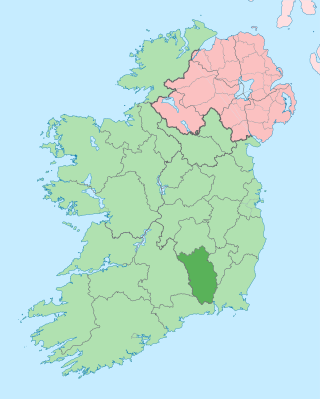
County Kilkenny is a county in Ireland. It is in the province of Leinster and is part of the Southern Region. It is named after the city of Kilkenny. Kilkenny County Council is the local authority for the county. At the 2022 census the population of the county was 103,685. The county was based on the historic Gaelic kingdom of Ossory (Osraighe), which was coterminous with the Diocese of Ossory.

<span class="mw-page-title-main">Kilkenny</span> City in Leinster, Ireland

Kilkenny is a city in County Kilkenny, Ireland. It is located in the South-East Region and in the province of Leinster. It is built on both banks of the River Nore. The 2022 census gave the population of Kilkenny as 27,184.

<span class="mw-page-title-main">Graiguenamanagh</span> Hamlet in County Kilkenny, Ireland

Graiguenamanagh or Graignamanagh is a town on the River Barrow in County Kilkenny, Ireland. Part of the settlement, known as Tinnahinch, is on the County Carlow side of the river, and Carlow County Council refers to the whole village as "Graiguenamanagh-Tinnahinch". Also combined for census purposes, as of the 2016 census, Graiguenamanagh-Tinnahinch had a population of 1,475 people.

<span class="mw-page-title-main">Thomastown</span> Town in County Kilkenny, Ireland

Thomastown, historically known as Grennan, is a town in County Kilkenny in the province of Leinster in the south-east of Ireland. It is a market town along a stretch of the River Nore which is known for its salmon and trout, with a number of historical landmarks in the vicinity. Visitor attractions include Jerpoint Abbey, Kilfane Glen gardens, and Mount Juliet Golf Course.

<span class="mw-page-title-main">River Nore</span> River in southern Ireland, one of the Three Sisters

The River Nore is one of the principal rivers in the South-East Region of Ireland. The 140-kilometre-long (87 mi) river drains approximately 2,530 square kilometres (977 sq mi) of Leinster and Munster, that encompasses parts of three counties. Along with the River Suir and River Barrow, it is one of the constituent rivers of the group known as the Three Sisters.

<span class="mw-page-title-main">Castlecomer</span> Town in County Kilkenny, Ireland

Castlecomer is a town in the north of County Kilkenny, Ireland. It is positioned at the meeting of N78 and R694 roads about 16 km (9.9 mi) north of Kilkenny city. At the 2016 census of the Central Statistics Office, the town's population included 1,502 people.

<span class="mw-page-title-main">Ballyragget</span> Town in County Kilkenny, Ireland

Ballyragget is a small town on the river Nore in the north of County Kilkenny in Ireland. Ballyragget is on the N77 18 km (11 mi) north of Kilkenny. As of the 2016 census, it had a population of 1,082 people.
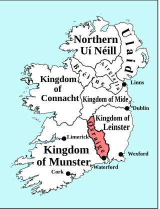
<span class="mw-page-title-main">Barrow Bridge</span> Railway bridge in southeast Ireland

Barrow rail bridge,, is a pratt truss type of railway bridge that spans the river Barrow between County Kilkenny and County Wexford in the south east of Ireland. This rural landmark with a length of 2,131 ft (650 m) is the longest bridge on the river. It was second longest bridge in Ireland and the third longest rail bridge on the islands of Ireland & Great Britain. Designed by Sir Benjamin Baker and built by the firm of Sir William Arrol. It is known locally as Barrow Bridge.

<span class="mw-page-title-main">Inistioge</span> Village in County Kilkenny, Ireland

Inistioge is a small village in County Kilkenny, Ireland. Historically, its name has been spelt as Ennistioge, Ennisteage, and in other ways. The village is situated on the River Nore, 25 kilometres (16 mi) southeast of Kilkenny.

<span class="mw-page-title-main">Bennettsbridge</span> Village in County Killkenny, Ireland

Bennettsbridge is a village in County Kilkenny in Ireland. It is situated on the River Nore 6 kilometres (3.7 mi) south of Kilkenny city, in the centre of the county. Bennettsbridge is a census town, and has population of 745 as of the 2016 census.

<span class="mw-page-title-main">St. Peter's Church, Ennisnag, Kilkenny</span> Church in County Kilkenny, Ireland

Saint Peter's Church, Ennisnag is a church of the United Dioceses of Cashel and Ossory and the ecclesiastical province of the United Provinces of Dublin and Cashel in the (Anglican) Church of Ireland. The church lies beside the Kings River, one mile north of Stoneyford village in County Kilkenny, Ireland. Located in the townland of Ennisnag, in the barony of Shillelogher.

<span class="mw-page-title-main">Kilkenny marble</span>

Kilkenny marble or Kilkenny black marble is a fine-grained very dark grey carboniferous limestone found around County Kilkenny in Ireland in the "Butlersgrove Formation", a Lower Carboniferous limestone that contains fossils of brachiopods, gastropods, crinoids and corals. The first and main source was the "Black Quarry" in the townlands of Archersgrove and Gallowshill just south of Kilkenny city, which was used from the 17th to the 19th century. Kilkenny is nicknamed "the Marble City"; the footpaths of the city streets were paved with Kilkenny marble flagstones, which were highly polished with wear and glistened when wet.

<span class="mw-page-title-main">Goresbridge</span> Village in County Kilkenny, Ireland

Goresbridge is a small village located in the east of County Kilkenny, in the province of Leinster, Ireland. Goresbridge is named after a 1756 bridge, built by Colonel Ralph Gore, which provides a crossing of the River Barrow between County Kilkenny and County Carlow in the South-East region.

<span class="mw-page-title-main">St Canice's Cathedral</span> Church in County Kilkenny, Ireland

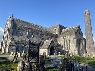
St Canice's Cathedral, also known as Kilkenny Cathedral, is a cathedral of the Church of Ireland in Kilkenny city, Ireland. It is in the ecclesiastical province of Dublin. Previously the cathedral of the Diocese of Ossory, it is now one of six cathedrals in the United Dioceses of Cashel and Ossory.

<span class="mw-page-title-main">Tomb of Saint Nicholas</span>

The tomb of Saint Nicholas is a slab effigy in low relief of an early 4th-century ecclesiastic popularly associated with Saint Nicholas of Myra in County Kilkenny, Ireland. While more probably a local priest from Jerpoint Abbey, it lies in the medieval lost town of Newtown Jerpoint, just west of the Cistercian Jerpoint Abbey.

Eland Mossom, Esq. M.P. was a lawyer, recorder of the City of Kilkenny, and representative in the Parliament of Ireland for the Borough of St Canice in Irishtown. He was the eldest son of Dean of Kilkenny Robert Mossom. He resided at Mount Eland, near Ballyraggett.

Sir Richard Shee was an Irish lawyer, politician, and Deputy Lord Treasurer of Ireland. He was a prominent member of the ruling class in Kilkenny city. He is best remembered for his influence on the architecture of Kilkenny city through his founding of the Shee Alms House in Rose Inn Street, Kilkenny, and for his ornate tomb in Saint Mary's Church.

John Bradley was a historian and archaeologist at NUI Maynooth. He grew up in Kilkenny and published many papers about his hometown.

Highhays is a townland and the location of a 14th-century Medieval pottery site. It was discovered in 2006 during excavations led by the late Emma Devine and Cóilín Ó Drisceoil. The excavations revealed a previously unknown suburb of Kilkenny which seemed to be the location of an industrial site dedicated to pottery. Amongst the 9,000 finds were a firing kiln, sherds of pottery, a ring-brooch, an ear scoop and decorated buckles. The type of pottery produced there has since been attributed the name Highhays Ware. It is found throughout Kilkenny city as well as other towns and castle sites in the Southeast of Ireland along the River Nore and River Barrow.

<span class="mw-page-title-main">Highhays Ware</span> Medieval pottery

Highhays Ware is a term used for medieval pottery produced at the Highhays pottery site in Kilkenny, Ireland. It was previously referred to as "Kilkenny-type ware". The pottery found during the excavations at the site included jugs, cooking pots, storage jars, money boxes, parts of pottery like spouts and ridge tiles or parts thereof, in total "42 sherds of [...] pottery and 160 ridge-tile fragments" from the kiln alone.

References

Further reading

Unpublished

  • Farrelly, J.; O'Reilly, B.; Loughran, B. (1993). The Urban Archaeological Survey County Kilkenny. Dublin: Office of Public Works.
  • Tierney, Ann (1996). Survey of the Bridges of the Nore in County Kilkenny. p. 24‐27.