The Sabine River is a river, 510 miles (820 km) long, in the Southern U.S. states of Texas and Louisiana. In its lower course, it forms part of the boundary between the two states and empties into Sabine Lake, an estuary of the Gulf of Mexico. Over the first half of the 19th century, the river formed part of the Spanish–American, Mexican–American, and Texan–American international boundaries. The upper reaches of the river flow through the prairie country of northeast Texas. Along much of its lower reaches, it flows through the pine forests along the Texas–Louisiana border, and the bayou country near the Gulf Coast.
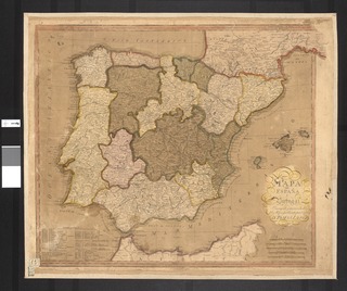
Spain is a country located in southwestern Europe occupying most of the Iberian Peninsula and includes a small exclave inside France called Llívia as well as the Balearic Islands in the Mediterranean, the Canary Islands in the Atlantic Ocean 108 km (67 mi) off northwest Africa, and five places of sovereignty on and off the coast of North Africa: Ceuta, Melilla, Islas Chafarinas, Peñón de Alhucemas, and Peñón de Vélez de la Gomera.

The Tagus is the longest river in the Iberian Peninsula. It is 1,007 km (626 mi) long, 716 km (445 mi) in Spain, 47 km (29 mi) along the border between Portugal and Spain and 275 km (171 mi) in Portugal, where it empties into the Atlantic Ocean near Lisbon. It drains an area of 80,100 square kilometers (30,927 sq mi). The Tagus is highly utilized for most of its course. Several dams and diversions supply drinking water to places of central Spain and Portugal, while dozens of hydroelectric stations create power. Between dams it follows a very constricted course, but after Almourol it enters a wide alluvial valley, prone to flooding. Its mouth is a large estuary near the port city of Lisbon.
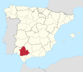
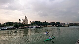
The Province of Seville is a province of southern Spain, in the western part of the autonomous community of Andalusia. It is bordered by the provinces of Málaga, Cádiz in the south, Huelva in the west, Badajoz in the north and Córdoba in the east. Seville is the province's as well as the Andalusian autonomous community's capital.

The Guadalete River is located almost entirely in the Spanish province of Cádiz, rising in the Sierra de Grazalema Natural Park at an elevation of about 1,000 metres (3,300 ft), and running for 172 kilometres (107 mi) into the Bay of Cádiz at El Puerto de Santa Maria, south of the city of Cádiz. The river's name comes from the Arabic phrase meaning "River of Forgetfulness".

Nagarjuna Sagar Dam is one of the world's largest and tallest Masonry dams built across the Krishna river at Nagarjuna Sagar which is in Nalgonda District, Telangana State, India. Constructed between 1955 and 1967, the dam created a water reservoir with gross storage capacity of 11.472 billion cubic metres. The dam is 590 feet (180 m) tall from its deepest foundation and 0.99 miles (1.6 km) long with 26 flood gates which are 42 feet (13 m) wide and 45 feet (14 m) tall.
The Battle of Alcolea took place on 28 September 1868, over a bridge above Guadalquivir river in the town of Alcolea, Córdoba, Spain. In this battle, revolutionary forces led by General Francisco Serrano y Domínguez defeated Queen Isabella II of Spain´s governmental forces commanded by general Manuel Pavía, forcing Isabella II of Spain to leave Spain and be exiled in France.

The Genil River is the main (left) tributary of the river Guadalquivir in Andalusia, Spain. The Roman Singilis, its modern name derives from the Moorish rendering of the Roman name: Sinyil, Sannil, and Sinnil. The source of the Genil is in the Sierra Nevada, north of its highest peak Mulhacén. The Genil flows through the towns Granada, Loja, Puente Genil and Écija. It flows into the Guadalquivir River near Palma del Río.

The Campiña Sur, officially the Mancomunidad de la Campiña Sur cordobesa, is a comarca of the province of Córdoba in Andalusia, Spain. It is formed by 11 municipalities and is between the Subbética Mountains and the Guadalquivir Valley, in the south-west of the province.

Isla Mayor is a municipality located in the province of Seville, Spain. According to the 2009 census, the municipality has a population of 5873 inhabitants.

Alto Guadalquivir is a Spanish comarca in the province of Córdoba. It covers an area of 1,299 km², and has a population of 44,828 inhabitants. It borders the comarca of Valle de los Pedroches to the North; Campiña Este - Guadajoz to the South; Córdoba and the comarca of Valle del Guadiato to the West; and the province of Jaén to the East.

The Calahorra tower is a fortified gate in the historic centre of Córdoba, Spain. The edifice is of Islamic origin.

The Tungabhadra Dam also known as Pampa Sagar is constructed across the Tungabhadra River, a tributary of the Krishna River. The dam is in Munirabad, Koppal district of Karnataka. It is a multipurpose dam serving irrigation, electricity generation, flood control, etc. This is a joint project of erstwhile Hyderabad state and erstwhile Madras Presidency when the construction was started; later it became a joint project of Karnataka and Andhra Pradesh after its completion in 1953. The main architect of the dam was Dr Thirumala Iyengar, an engineer from Madras. There is a dispute between Andhra Pradesh,Telangana and Karnataka for the water of Tungabhadra reservoir. The main contractor for the dam was Venkat Reddy Mulamalla, from Konour village, Mahabubnagar, Hyderabad state.
The Battle of Alcolea Bridge was a minor battle that took place on 7 June 1808, during the Peninsular War, at Alcolea, a small village 10 km from Córdoba, the city that would be invaded by French troops later that same afternoon.
Alcolea is a town near Córdoba, Spain. The town is significant for its 19-arch bridge, built between 1785 and 1792, crossing the Guadalquivir, and which was the site of two battles in the 19th century.

The Zújar is a 214 km long river in Spain. It the largest left hand tributary to the Guadiana.

The Andalusia Bridge is a cable-strayed bridge. It crosses the Guadalquivir River in Córdoba, Spain, carrying a road which connects the airport and an industrial zone. Its opening was on 28 February 2004.