External links
Coordinates: 32°17′39″N115°06′16″W / 32.29417°N 115.10444°W
| | This article about a location in the Mexican state of Baja California is a stub. You can help Wikipedia by expanding it. |
Guadalupe Victoria, also known as the 43, is a small city in the state of Baja California in northern Mexico. Its population at the 2018 census was 20,222 inhabitants. It is located in the municipality of Mexicali and serves as a borough seat of its surrounding area.
Economically, it serves as an agricultural hub supplying the numerous cotton and wheat farms and ranches in the surrounding area
Its name honors the first president of Mexico, Guadalupe Victoria. Other names by which it is known locally include Estación Victoria and "el cuarenta y tres" (the 43) These latter two names are due to the town's location on kilometer 43 on the former Ferrocarril Sonora-Baja California railroad, today a line of Ferromex, connecting Mexicali and the border with Benjamin Hill, Sonora and Guadalajara.
The city includes a sub-campus of the Universidad Autónoma de Baja California.
It is located near the epicenter of the 2010 Baja California earthquake.
Coordinates: 32°17′39″N115°06′16″W / 32.29417°N 115.10444°W
| | This article about a location in the Mexican state of Baja California is a stub. You can help Wikipedia by expanding it. |

The Baja California Peninsula is a peninsula in Northwestern Mexico. It separates the Pacific Ocean from the Gulf of California. The peninsula extends 1,247 km from Mexicali, Baja California in the north to Cabo San Lucas, Baja California Sur in the south. It ranges from 40 km at its narrowest to 320 km at its widest point and has approximately 3,000 km of coastline and approximately 65 islands. The total area of the Baja California Peninsula is 143,390 km2 (55,360 sq mi), roughly the same area as the country of Nepal.
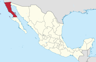
Baja California, officially the Free and Sovereign State of Baja California is a state in Mexico. It is the northernmost and westernmost of the 32 federal entities of Mexico. Before becoming a state in 1952, the area was known as the North Territory of Baja California. It has an area of 70,113 km2 (27,071 sq mi) and comprises the northern half of the Baja California Peninsula, north of the 28th parallel, plus oceanic Guadalupe Island. The mainland portion of the state is bordered on the west by the Pacific Ocean; on the east by Sonora, the U.S. state of Arizona, and the Gulf of California; on the north by the U.S. state of California; and on the south by Baja California Sur.

Baja California Sur, officially the Free and Sovereign State of Baja California Sur, is the second-smallest Mexican state by population and the 31st admitted state of the 32 states which make up the 32 Federal Entities of Mexico. It is also the ninth-largest Mexican state in terms of area.

Mexicali is the capital city of the Mexican state of Baja California and seat of the Municipality of Mexicali. The City of Mexicali has a population of 689,775, according to the 2010 census, while the population of the entire metropolitan area reaches 936,826; making the city and metropolitan area the second most populous in Baja California.

Ensenada is a coastal city in Mexico, the third-largest in Baja California. Lying 125 kilometres (78 mi) south of San Diego on the Baja California Peninsula, it is locally referred to as La Cenicienta del Pacífico, "The Cinderella of the Pacific".

Sonoyta, Sonora is a town in the northern Mexican state of Sonora. It stands on the U.S.-Mexico border, facing Lukeville, Arizona, in the United States. It is the municipal seat of the municipality of Plutarco Elías Calles.

Los Algodones, Baja California, is a small Mexican town located on the extreme northeastern tip of the municipality of Mexicali, approximately 16 km (9.9 mi) west of Yuma, Arizona, USA. Its official name is Vicente Guerrero, and it is informally known as Molar City, because of the large number of dentists that cater to Americans. It reported a population of 5,474 as of the 2010 Mexican census. It also serves as a borough seat of its surrounding area.

San Felipe is a town on the bay of San Felipe in the Gulf of California in the Mexican state of Baja California, 190 km south of the United States border and within the municipality of Mexicali. The population of San Felipe was 17,708 at the 2015 census, and can increase by up to 5,000 due to the presence of Canadian and U.S. part-time residents, who travel to the town from the United States during the American holidays Spring Break and Memorial Day. It also serves as a borough seat of its surrounding area.

Municipalities are the second-level administrative divisions of Mexico, where the first-level administrative division is the state. They should not be confused with cities or towns that may share the same name as they are distinct entities and do not share geographical boundaries. As of January 2021, there are 2,454 municipalities in Mexico, excluding the 16 boroughs of Mexico City.

Mexicali Municipality is a municipality in the Mexican state of Baja California. Its municipal seat is located in the city of Mexicali. As of 2020, the municipality had a total population of 1,049,792. The municipality has an area of 13,700 km2 (5,300 sq mi). This includes many smaller outlying communities as well as the city of Mexicali. Also, the islands of Baja California located in the Gulf of California are part of the municipality, among them the mudflat islands at the mouth of the Colorado River, Isla Ángel de la Guarda and the islands of the San Lorenzo Marine Archipelago National Park. Mexicali is the northernmost municipality of Latin America.

The Spanish missions in Baja California were a large number of religious outposts established by Catholic religious orders, the Jesuits, the Franciscans and the Dominicans, between 1683 and 1834 to spread the Christian doctrine among the Native Americans or Indians living on the Baja California peninsula. The missions gave Spain a valuable toehold in the frontier land, and introduced European livestock, fruits, vegetables, and industry into the region. The Indians were severely impacted by the introduction of European diseases such as smallpox and measles and by 1800 their numbers were a fraction of what they had been before the arrival of the Spanish.
The Hardy River is a 26-kilometer (16 mi)-long Mexican river formed by residual agricultural waters from the Mexicali Valley, and running into the Colorado River. The river is believed to have been an ancient channel of the Colorado. In the 19th century, an English lieutenant, R. W. H. Hardy, explored the Colorado River Delta, and noted that the main channel of the Colorado followed this course. Later, in the 1880s, sea captains noted that the main channel of the Colorado had moved east; this earlier channel became known as Hardy's Colorado.
Venustiano Carranza is a small community located in the Mexican State of Baja California. It is located in the municipality of Mexicali and serves as a borough seat of its surrounding area.
San Luis Río Colorado is a municipality in Sonora state, in northwestern Mexico.

The 2010 Baja California earthquake occurred on April 4 with a moment magnitude of 7.2 and a maximum Mercalli intensity of VII. The shock originated at 15:40:41 local time south of Guadalupe Victoria, Baja California, Mexico.
Santa Isabel – Saint Isabel – is a city in Baja California in Mexicali Municipality. The city had a population of 33,604 as of 2018. Santa Isabel is the second largest city in the municipality and part of the Mexicali metropolitan area, is located west of the capital city Mexicali. The city is named after Saint Elizabeth of Portugal, called Isabel in Spanish.
The Autonomous University of Baja California is a public institution of higher education in the Mexican state of Baja California. UABC is one of the 43 state universities throughout Mexico as part of the country's state university system. Its headquarters are located in the city of Mexicali.

The Autonomous University of Baja California, Campus Mexicali is a public research university located on several campuses in the metropolitan area of Mexicali, Baja California. It is a branch of the Autonomous University of Baja California.

'Batáquez' , 'Estación Batáquez' or 'Ejido Monterrey' , is a locality Mexican of the Valley of Mexicali, in the municipality from Mexicali, Baja California. According to data from INEGI, it is located at coordinates 32 ° 32'58 north latitude and 115 ° 04'15 west longitude and had 1,121 inhabitants in 2010. Despite being a small locality, Batáquez has local importance since it is head of the municipal delegation of the same name.