Guatemala City metropolitan area

Last updated

The Guatemala City metropolitan area (Área Metropolitana de Guatemala or AMG) is a conglomeration of densely populated municipalities surrounding Guatemala City. In 2005, the metropolitan area was defined by the governments of Guatemala and Guatemala City as comprising the municipalities of Amatitlán, Chinautla, Guatemala City, Mixco, San Miguel Petapa, Santa Catarina Pinula, Villa Canales and Villa Nueva. [1] Together these eight municipalities cover 478 square kilometres [1] and were projected by Guatemala's National Institute of Statistics to have a combined population of 2,749,161 in 2015. [2]

Municipalities of Guatemala administrative division

The departments of Guatemala are divided into 340 municipalities or municipios. The municipalities are listed below, by department.

Guatemala City City in Guatemala, Guatemala

Guatemala City, locally known as Guatemala or Guate, officially Nueva Guatemala de la Asunción, is the capital and largest city of Guatemala, and the most populous in Central America. The city is located in the south-central part of the country, nestled in a mountain valley called Valle de la Ermita. It is estimated that its population is about 1 million. Guatemala City is also the capital of the Municipality of Guatemala and of the Guatemala Department.

Amatitlán Place in Guatemala Department, Guatemala

Amatitlán is a town in the Guatemala department of Guatemala.

Related Research Articles

Guatemala Department Department in Guatemala City, Guatemala

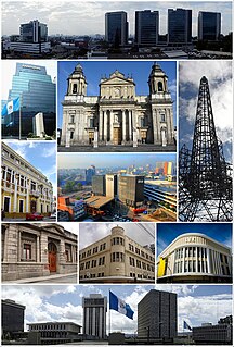
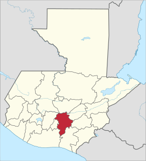
Guatemala is one of the 22 departments of Guatemala. The capital is Guatemala City, which also serves as the national capital. The department consists of Guatemala City and several of its suburbs.

El Progreso Department Department in Guastatoya, Guatemala

El Progreso is a department in Guatemala. The departmental capital is Guastatoya. The Spanish established themselves in the region by 1551, after the Spanish conquest of Guatemala. El Progreso was declared a department in 1908, but was dissolved in 1920 before being reestablished in 1934. Guastatoya was badly affected by the 1976 Guatemala earthquake.

Retalhuleu Department Department in Retalhuleu, Guatemala

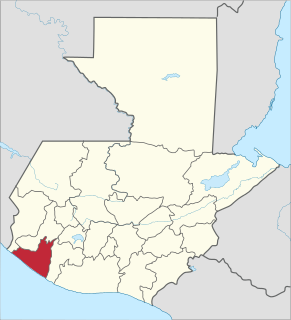
Retalhuleu is a department located in the south-west of Guatemala, extending from the mountains to the Pacific Ocean coast. It has an area of 1856 km². In 2002 the population of the Department of Retalhuleu was 241,411. The capital is the city of Retalhuleu.

San Pedro Carchá Municipality in Alta Verapaz, Guatemala

San Pedro Carchá, usually referred to as Carchá, is a municipality in the Guatemalan department of Alta Verapaz. It is situated at 1282 m above sea level. It has an estimated population 245,000 people. It covers a terrain of 1082 km².

San Juan Comalapa Municipality and town in Chimaltenango, Guatemala

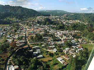
San Juan Comalapa is a municipality in the Chimaltenango department of Guatemala.

Zaragoza, Chimaltenango Municipality and town in Chimaltenango, Guatemala

Zaragoza is a municipality in the Chimaltenango department of Guatemala.

Mixco Place in Guatemala, Guatemala

Mixco is a municipality in the Guatemala department of Guatemala.

Santa Catarina Pinula municipality in Guatemala, Guatemala

Santa Catarina Pinula is a municipality in the Guatemala Department of Guatemala. Its name, according to Guatemalan colonial historian Francisco Antonio de Fuentes y Guzmán in his book Recordación Florida comes from:

Moyuta Place in Jutiapa, Guatemala

Moyuta is a municipality in the Jutiapa department of Guatemala.

Comitancillo Place in San Marcos, Guatemala

Comitancillo is a municipality in the San Marcos department of Guatemala.The spoken language is Mam.The municipality was founded by the Spaniards between 1633 and 1648 year. There is an archaeological site called Chipel, with remains of the Mam culture.

Sipacapa Municipality of Guatemala in San Marcos

Sipacapa is a municipality in the San Marcos department, situated in the Western highlands of Guatemala. Sipacapa's population of around 14,000 is spread among 14 village communities, scattered over mountainous terrain. Sipacapa is considered a linguistic community, as Sipakapense is a Maya language unique to the municipality.

Naciones Unidas National Park is a forested park area of 4.91 km2, located 21 km south of Guatemala City, just north of Lake Amatitlán in the municipality of Villa Nueva. It is one of the last remaining nature reserves in the metropolitan area of Guatemala City.

Museo Regional de Arqueología de la Democracia, Escuintla

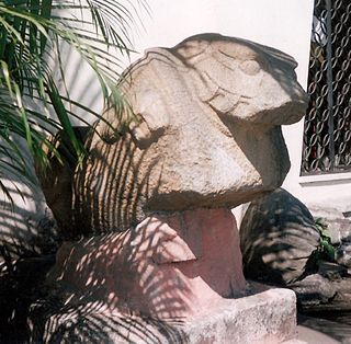
The Museo Regional de Arqueología de la Democracia is an archaeological museum in the municipality of La Democracia in the department of Escuintla in Guatemala. The museum displays pre-Columbian Mesoamerican artefacts from the Pacific lowlands datingfrom the Preclassic Period through to the Postclassic Period, with a particular emphasis upon the local Monte Alto culture. The museum is open from Tuesday through to Saturday from 8am to 4pm.

References

  1. 1 2 Proyecto GUA/04/022: Programa de Desarrollo Metropolitano de la Municipalidad de Guatemala (PDF) (Report). Ministry of Foreign Affairs (Guatemala) . Retrieved 25 April 2016.
  2. Guatemala: Estimaciones de la Población total por municipio. Período 2008-2020. (al 30 de junio) (PDF) (Report). Instituto Nacional de Estadistica Guatemala. Archived from the original (PDF) on 2015-04-04. Retrieved 2015-06-03.

Coordinates: 14°36′48″N90°32′07″W / 14.6133°N 90.5353°W / 14.6133; -90.5353

Geographic coordinate system Coordinate system

A geographic coordinate system is a coordinate system that enables every location on Earth to be specified by a set of numbers, letters or symbols. The coordinates are often chosen such that one of the numbers represents a vertical position and two or three of the numbers represent a horizontal position; alternatively, a geographic position may be expressed in a combined three-dimensional Cartesian vector. A common choice of coordinates is latitude, longitude and elevation. To specify a location on a plane requires a map projection.