A gulf is a large inlet from the ocean into a landmass.
Contents
Gulf or the gulf may also refer to:
A gulf is a large inlet from the ocean into a landmass.
Gulf or the gulf may also refer to:

The Gulf Coast of the United States, also known as the Gulf South, is the coastline along the Southern United States where they meet the Gulf of Mexico. The coastal states that have a shoreline on the Gulf of Mexico are Texas, Louisiana, Mississippi, Alabama, and Florida, and these are known as the Gulf States.

The Gulf of Oman or Sea of Oman, also known as Gulf of Makran or Sea of Makran, is a gulf that connects the Arabian Sea with the Strait of Hormuz, which then runs to the Persian Gulf. It borders Iran and Pakistan on the north, Oman on the south, and the United Arab Emirates on the west.
Indian or Indians may refer to:

North America is a continent in the Northern Hemisphere and almost entirely within the Western Hemisphere. It is bordered to the north by the Arctic Ocean, to the east by the Atlantic Ocean, to the southeast by South America and the Caribbean Sea, and to the west and south by the Pacific Ocean. Because it is on the North American Tectonic Plate, Greenland is included as a part of North America geographically.

The Persian Gulf, sometimes called the Arabian Gulf, is a mediterranean sea in Western Asia. The body of water is an extension of the Indian Ocean located between Iran and the Arabian Peninsula. It is connected to the Gulf of Oman in the east by the Strait of Hormuz. The Shatt al-Arab river delta forms the northwest shoreline.
Seneca may refer to:

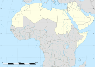
The Arab world, formally the Arab homeland, also known as the Arab nation, the Arabsphere, or the Arab states, consists of the 22 Arab countries which are members of the Arab League. A majority of these countries are located in Western Asia, Northern Africa, Western Africa, and Eastern Africa. The region stretches from the Atlantic Ocean in the west to the Arabian Sea in the east, and from the Mediterranean Sea in the north to the Indian Ocean in the southeast. The eastern part of the Arab world is known as the Mashriq, and the western part as the Maghreb. Arabic is used as the lingua franca throughout the Arab world.
GOM may refer to:

A subregion is a part of a larger region or continent and is usually based on location. Cardinal directions, such as south are commonly used to define a subregion.
Atlantis is a legendary island first mentioned by Plato.

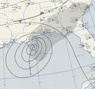
Hurricane Hilda was an intense tropical cyclone that ravaged areas of the United States Gulf Coast, particularly Louisiana. In addition to its damage inland, the hurricane greatly disrupted offshore oil production, and at its time was the costliest tropical cyclone for Louisiana's offshore oil production. Due in part to flights made by the National Hurricane Research Laboratory, Hilda became one of the most well-documented storms meteorologically in the Atlantic. Lasting for seven days as a tropical cyclone, Hilda caused US$126 million in damage and 38 deaths. It was the tenth named storm, sixth hurricane, and the fourth major hurricane of the 1964 Atlantic hurricane season.
GIS is a computer-based system to analyse and present spatial data.
Native Americans or Native American may refer to:

Hurricane Flossy originated from a tropical disturbance in the eastern Pacific Ocean and moved across Central America into the Gulf of Mexico as a tropical depression on September 21, 1956, which became a tropical storm on September 22 and a hurricane on September 23. The hurricane peaked with maximum sustained winds of 90 mph (150 km/h) before it struck the central Gulf coast of the United States as a Category 1 hurricane on September 24, and evolved into an extratropical cyclone on September 25. It was the first hurricane to affect oil refining in the Gulf of Mexico. The tropical cyclone led to flooding in New Orleans, and broke a drought across the eastern United States. The death toll was 15, and total damages reached $24.8 million (1956 USD).

A continental divide is a drainage divide on a continent such that the drainage basin on one side of the divide feeds into one ocean or sea, and the basin on the other side either feeds into a different ocean or sea, or else is endorheic, not connected to the open sea. Every continent on earth except Antarctica has at least one continental drainage divide; islands, even small ones like Killiniq Island on the Labrador Sea in Canada, may also host part of a continental divide or have their own island-spanning divide. The endpoints of a continental divide may be coastlines of gulfs, seas or oceans, the boundary of an endorheic basin, or another continental divide. One case, the Great Basin Divide, is a closed loop around an endoreic basin. The endpoints where a continental divide meets the coast are not always definite since the exact border between adjacent bodies of water is usually not clearly defined. The International Hydrographic Organization's publication Limits of Oceans and Seas defines exact boundaries of oceans, but it is not universally recognized. Where a continental divide meets an endorheic basin, such as the Great Divide Basin of Wyoming, the continental divide splits and encircles the basin. Where two divides intersect, they form a triple divide, or a tripoint, a junction where three watersheds meet.

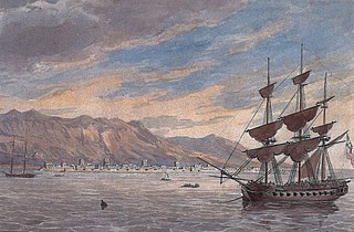
The Persian Gulf Campaign, in 1809, was an operation by the British East India Company backed by the Royal Navy to force the Al Qasimi to cease their raids on British ships in the Persian Gulf, particularly on the Persian and Arab coasts of the Straits of Hormuz. The operation's success was limited as the Royal Navy forces, already heavily involved in the Napoleonic Wars, were unable to permanently suppress the strong fleets of the Al Qasimi of Ras Al Khaimah and Sharjah. The expedition did achieve its short-term goals by destroying three Al Qasimi bases and over 80 vessels, including the largest Al Qasimi ship in the region, the converted merchant ship Minerva. Although operations continued into 1810, the British were unable to destroy every Al Qasimi vessel and by 1811 attacks had resumed, although at a lower intensity than previously.

The Gulf of Mexico is an ocean basin and a marginal sea of the Atlantic Ocean, largely surrounded by the North American continent. It is bounded on the northeast, north and northwest by the Gulf Coast of the United States; on the southwest and south by the Mexican states of Tamaulipas, Veracruz, Tabasco, Campeche, Yucatan, and Quintana Roo; and on the southeast by Cuba. The Southern U.S. states of Texas, Louisiana, Mississippi, Alabama, and Florida, which border the Gulf on the north, are often referred to as the "Third Coast" of the United States.