
Montgomery County is a county in the U.S. state of Georgia. As of the 2010 census, the population was 9,123. The county seat is Mount Vernon.

The Ocmulgee River (ok-MUHL-gee) is a western tributary of the Altamaha River, approximately 255 mi (410 km) long, in the U.S. state of Georgia. It is the westernmost major tributary of the Altamaha.

Ocmulgee Mounds National Historical Park, formerly Ocmulgee National Monument, in present-day Macon, Georgia, United States, preserves traces of over ten millennia of Southeastern Native American culture. Its chief remains are major earthworks built before 1000 CE by the South Appalachian Mississippian culture These include the Great Temple and other ceremonial mounds, a burial mound, and defensive trenches. They represented highly skilled engineering techniques and soil knowledge, and the organization of many laborers. The site has evidence of "17,000 years of continuous human habitation." The 702-acre (2.84 km2) park is located on the east bank of the Ocmulgee River. Present-day Macon, Georgia developed around the site after the United States built Fort Benjamin Hawkins nearby in 1806 to support trading with Native Americans.
The Alcovy River is a 69-mile-long (111 km) tributary of the Ocmulgee River in north-central Georgia in the United States. Via the Ocmulgee River, it is part of the watershed of the Altamaha River, which flows to the Atlantic Ocean.

Little Ocmulgee State Park & Lodge is a 1,360-acre (550 ha) Georgia state park located 2 miles (3.2 km) north of McRae on the Little Ocmulgee River. Part of the park was initially built by the Civilian Conservation Corps during the Great Depression, around the natural diversion of the Little Ocmulgee into a lake. This is a 256-acre (104 ha) lake with beach, and the park includes a 60 room lodge and a championship 18-hole golf course with pro shop, known as the Wallace Adams Memorial Golf Course. The soil around the Ocmulgee River and the Little Ocmulgee is a fine white sand, and therefore the lake has its own "beach sand". Also within the park is the 2.6-mile (4.2 km) long Oak Ridge Trail, allowing visitors to see native wildlife and plants.
Cusseta, also known as Kasihta was a peace town of the Lower Creeks, a division of the Muscogee Creek Confederacy. It was located in what is now the state of Georgia.
The Alabaha River is a 20.6-mile-long (33.2 km) tributary of the Satilla River in the U.S. state of Georgia. It forms in northwestern Pierce County at the junction of Hurricane Creek and Little Hurricane Creek and flows southeast, past the county seat of Blackshear, and joins the Satilla River at the Pierce County/Brantley County boundary.
Alligator Creek is a 48.6-mile-long (78.2 km) tributary of the Little Ocmulgee River in the U.S. state of Georgia.

Big Satilla Creek is a 55.8-mile-long (89.8 km) tributary of the Little Satilla River in the U.S. state of Georgia. It is part of the Satilla River watershed of southeastern Georgia.

The Little Satilla Creek is a 39.3-mile-long (63.2 km) tributary of the Little Satilla River in the U.S. state of Georgia. It is part of the Satilla River watershed in southeastern Georgia.
Rocky Comfort Creek is a 62.4-mile-long (100.4 km) tributary of the Ogeechee River in the U.S. state of Georgia. Rising in Warren County 9 miles (14 km) northwest of Warrenton, it flows southeast, entering Glascock County and passing the town of Gibson, then continuing south into Jefferson County, where it reaches the Ogeechee River at Louisville.
Tobesofkee Creek is a 58.9-mile-long (94.8 km) river in Georgia. It originates near Barnesville and flows roughly southeast across Lamar, Monroe, and Bibb counties to join the Ocmulgee River south of the city of Macon. A dam on this stream forms Lake Tobesofkee.

The Towaliga River is a 52.3-mile-long (84.2 km) tributary of the Ocmulgee River in central Georgia. The Towaliga passes through High Falls State Park in northwestern Monroe County, then traverses the county and joins the Ocmulgee near the town of Juliette. The river is fairly muddy above High Falls Lake, but it clears once below the falls where most of the river is rock bottomed. This region is about 50 miles (80 km) south of Atlanta and about 35 miles (56 km) north of Macon.
The Williamson Swamp Creek is a 52.4-mile-long (84.3 km) tributary of the Ogeechee River in the U.S. state of Georgia. Rising in northwestern Washington County 12 miles (19 km) north of Sandersville, it flows southeast past Davisboro and enters Jefferson County, ending at the Ogeechee River 5 miles (8 km) southeast of Wadley.
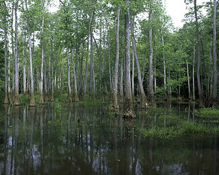
Bond Swamp National Wildlife Refuge, located 6 miles (9.7 km) south of Macon, Georgia, United States, was established in 1989 to protect, maintain and enhance the forested wetland ecosystem of the Ocmulgee River floodplain. It opened to the public in 2000 and currently consists of 6,500 acres (26 km2) situated along the fall line separating the Piedmont and Coastal Plains. The refuge has a diversity of vegetation communities, including mixed hardwood-pine, bottomland hardwoods, tupelo gum swamp forests, creeks, tributaries, beaver swamps and oxbow lakes. The refuge is rich in wildlife diversity including white-tailed deer, wood ducks, black bears, alligators, wild turkey, a nesting pair of bald eagles and excellent wintering habitat for waterfowl. Extensive bottomland hardwoods provide critical habitat for neotropical songbirds of concern, such as Swainson's warbler, wood thrush, prothonotary warbler and yellow-billed cuckoo. The combination of warm weather and wet areas at Bond Swamp provide ideal conditions for a variety of reptile and amphibian species.
Big Indian Creek is a stream in the U.S. state of Georgia. It is a tributary to the Ocmulgee River.
Walnut Creek is a 30-mile-long (48 km) tributary of the South River in the U.S. state of Georgia. It originates in the city of Hampton in Henry County and flows into South River, which is a branch of the Ocmulgee River.
Walnut Creek is a 25-mile-long (40 km) tributary of the Ocmulgee River in the U.S. state of Georgia. It originates in the city of Gray in Jones County and flows into the Ocmulgee River in Macon at the southern corner of Ocmulgee National Monument.


