
Haig
Location of Haig in British Columbia
Haig is a settlement in British Columbia. It was named for Douglas Haig, 1st Earl Haig, a British senior officer during the First World War. [1]
Haig is a settlement in British Columbia. It was named for Douglas Haig, 1st Earl Haig, a British senior officer during the First World War. [1]

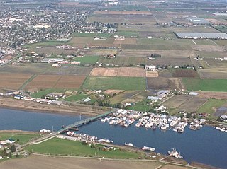
Cache Creek is a historic transportation junction and incorporated village 354 kilometres (220 mi) northeast of Vancouver in British Columbia, Canada. It is on the Trans-Canada Highway in the province of British Columbia at a junction with Highway 97. The same intersection and the town that grew around it was at the point on the Cariboo Wagon Road where a branch road, and previously only a trail, led east to Savona's Ferry on Kamloops Lake. This community is also the point at which a small stream, once known as Riviere de la Cache, joins the Bonaparte River.

Madeira Park is an unincorporated community in the area of Pender Harbour on the Sunshine Coast of southwestern British Columbia, Canada.
Laidlaw is an unincorporated settlement in the Upper Fraser Valley region of British Columbia, Canada, located just west of the westernmost boundary of Hope, British Columbia on the south side of the Fraser River and along the Trans-Canada Highway.
Halfmoon Bay is a small community in British Columbia, Canada, within the shíshálh swiya, and Electoral Area B of the Sunshine Coast Regional District. The population consists of approximately 2,800 people, including a large number of seasonal residents. The community is named for the large scalloped bay on which it sits, which is sheltered by South Thormanby Island and Vancouver Island.
Merville is an unincorporated community in the Comox Valley between the City of Courtenay, Mount Washington, Dove Creek, and Black Creek near the east coast of Vancouver Island. It was named by Canadian World War I soldiers returning to the Island after fighting in France; they named it after Merville-Franceville-Plage, where the Canadians had their first field headquarters.
Norbury Lake Provincial Park is a 97-hectare (240-acre) provincial park in British Columbia, Canada.
Westham Island is an island located near Ladner, British Columbia, Canada within the City of Delta, which in turn is part of Greater Vancouver, Canada. The George C. Reifel Migratory Bird Sanctuary for migratory birds is located at the northern end of the island, home to over 300 bird species. Every year in October, almost 85,000 Lesser Snow Geese arrive as they travel from Wrangel Island to the Atlantic. The Alaksen National Wildlife Area is also located on the island.

Harewood is the name of a lake and a plain of the Canadian province of British Columbia. It is located in Nanaimo, on the east coast of Vancouver Island. Its geographical coordinates are 49°08′N123°57′W The name has been in use since at least 1913, when Harewood referred to a small mining village in the area, no longer existing, having been overtaken by Nanaimo. The mine was owned in part by the seventh son of Henry Lascelles, 3rd Earl of Harewood who served on the BC coast as captain of the gunboat HMS Forward and set up the Harewood Coal Mining Company to work deposits he acquired.
Errington is a small community on Vancouver Island, British Columbia, Canada, located on Errington Road, off Highway 4, just south of Parksville and Qualicum Beach.

De Courcy Island is one of the Gulf Islands of the coast of southwestern British Columbia, Canada, located between the Pylades and Stuart Channels approximately 16 km (9.9 mi) southeast of Nanaimo and approximately 38 km (24 mi) west of Vancouver.
Point Grey is a headland marking the southern entrance to English Bay and Burrard Inlet in British Columbia, Canada. The headland is the site of Wreck Beach, Tower Beach, Point Grey Beach and most notably, since 1925, on its top is the Point Grey Campus of the University of British Columbia.
Douglas, formerly known as "Doug," is a locality in Surrey, British Columbia, Canada. Just southeast and outside of the boundary of White Rock, it is on the Canadian side of the Peace Arch Border Crossing between British Columbia and Whatcom County, Washington State, in the United States. Douglas is the location of the Peace Arch Provincial Park portion of the International Peace Arch Park, which it shares with Peace Arch State Park in Blaine, Washington.
Silverdale is a semi-rural neighbourhood of the District of Mission, British Columbia, Canada, located about 40 km east of Vancouver on the east bank of the Stave River at its confluence with the Fraser. Noted for its historic Italian Canadian community, its economy was farming, fishing and logging based until the general suburbanization of Fraser Valley life in the 1960s and 1970s. Of its Italian community, notable offspring include Phil Gaglardi, former BC Highways minister, and speed-skater Eden Donatelli. Silverdale is also notable as the site of Canada's first train robbery, by the "Gentleman Bandit" Billy Miner, and it is there he is supposed to have first used the polite "Hands Up!" in the course of the robbery.
North Bend is an unincorporated community in the Fraser Canyon region of British Columbia, Canada, located across the Fraser River from the town of Boston Bar. North Bend was originally known as Boston Bar, but that name moved across the Fraser River when the site was renamed North Bend.
Mount Haig-Brown is a mountain on Vancouver Island, British Columbia, Canada, located 22 km (14 mi) east of Gold River and 4 km (2 mi) south of Mount Filberg. The peak, at the north end of Buttle Lake, commemorates noted author and conservationist Roderick Haig-Brown and his wife Anne.

The Ashnola River is a tributary of the Similkameen River, rising in the northeastern part of the North Cascades in Washington, United States, and flowing north into British Columbia, Canada, to join the Similkameen River about halfway along that river's course between the towns of Princeton and Keremeos. The river crosses the international boundary at 49°00′00″N120°19′37″W and transits Cathedral Provincial Park. It has one main tributary, Ewart Creek, which is about 25 kilometres (16 mi) long and begins virtually at the border and is entirely within Cathedral Park.
Boothroyd is a settlement in the Fraser Canyon region of British Columbia, just north of Boston Bar-North Bend. It sits on a flat, alluvial bench which is some of the only flat land in the Fraser Canyon. It was the site of a Cariboo Roadhouse, run by a man named Boothroyd. Later it was a camp for Canadian Pacific Railway Chinese construction workers from 1882 to 1884.
Burton is a settlement on the east shore of Lower Arrow Lake in the West Kootenay region of southeastern British Columbia.
Lowhee Creek is a creek located in the Cariboo region of British Columbia. The creek was discovered in 1861 by Richard Willoughby who struck it rich here in 1861. He named it after a secret society at Yale University. The creek was mined for gold and was productive in the 1860s. The richest ground was where the stream flows into the meadows. This creek has been worked using sluicing, drifting, and hydraulicking.
Webster's Corners is a community in British Columbia, located northeast of Albion in Maple Ridge, British Columbia. Webster's Corners was founded by James Murray Webster who was born in Aberdeen, Scotland. James Webster arrived in 1883 and was the first postmaster. He named the settlement after himself.
49°23′46″N121°27′18″W / 49.396°N 121.455°W
| | This article about a location in the Interior of British Columbia, Canada is a stub. You can help Wikipedia by expanding it. |