
Poling is a village and civil parish in the Arun District of West Sussex, England, 2 miles (3.2 km) southeast of Arundel on a minor road south of the A27. About 25% of the parish is wooded foothill slopes of the South Downs which is the area north of the A27 here.

George Somers Clarke (1841–1926) was an architect and English Egyptologist who worked on the restoration and design of churches and at a number of sites throughout Egypt, notably in El Kab, where he built a house. He was born in Brighton.
Rudgwick is a village and civil parish in the Horsham District of West Sussex, England. The village is 6 miles (10 km) west from Horsham on the north side of the A281 road. The parish's northern boundary forms part of the county boundary between Surrey and West Sussex.
Henry Woodyer (1816–1896) was an English architect, a pupil of William Butterfield and a disciple of A. W. N. Pugin and the Ecclesiologists.

Wiggonholt is a village and former civil parish, now in the parish of Parham, in the Horsham district of West Sussex, England. It is 1.5 miles (2.4 km) southeast of Pulborough on the A283 road. The village consists of a farm, a few houses and a small Church of England parish church. In 1931 the parish had a population of 54. On 1 April 1933 the parish was abolished and merged with Parham.

St Mary de Haura Church is an Anglican church in the ancient "New Shoreham" area of Shoreham-by-Sea in the district of Adur, one of seven local government districts in the English county of West Sussex. It was founded at the end of the 11th century as a large cruciform church which, due to its original scale, has been described as a collegiate church—a reflection of the port of Shoreham's importance at the time. The former east end of that building survives to form the present church, and much 12th-century work remains. It functions as Shoreham-by-Sea's "town church" for major religious and social events, as well as serving as the town-centre parish. English Heritage has listed it at Grade I for its architectural and historical importance.
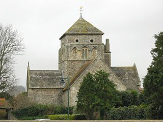
St Nicolas Church is an Anglican church in Old Shoreham, an ancient inland settlement that is now part of the town of Shoreham-by-Sea in the district of Adur, one of seven local government districts in the English county of West Sussex. It was founded on a riverside site by Anglo-Saxons at the start of the 10th century, possibly on the site of a 5th-century predecessor. Some Saxon-era structural elements remain despite 12th-century additions made when Shoreham became prosperous, further extension in the 14th century and a Victorian restoration. The cruciform structure, with its solid central tower, features some unusual Norman-era carving. English Heritage has listed it at Grade I for its architectural and historical importance.
Coombes Church is a Church of England parish church in the rural hamlet of Coombes in the Adur District of West Sussex, England. It has served the rural parish, northwest of Shoreham-by-Sea and next to the River Adur, since the 11th century. Despite several re-buildings, some structural elements remain from that period. An important series of wall paintings, dating from the 12th to the 18th century, were uncovered in 1949. English Heritage has listed the church at Grade I for its architectural and historical importance.
Worthing, a town with borough status in the English county of West Sussex, has 212 buildings with listed status. The Borough of Worthing covers an area of 8,030 acres (3,250 ha) on the south coast of England, facing the English Channel. The town's development in the early 19th century coincided with nearby Brighton's rise as a famous, fashionable resort, and Worthing became a quiet seaside town with a large stock of Victorian buildings. Residential growth in the 20th century absorbed nearby villages, and older houses, churches and mansions became part of the borough. The Town and Country Planning Act 1947, an act of Parliament effective from 1948, introduced the concept of "listing" buildings of architectural and historical interest, and Worthing Borough Council nominated 90 buildings at that time. More have since been added, but others have been demolished. As of 2009, Worthing has three buildings of Grade I status, 11 listed at Grade II*, 196 of Grade II status and three at the equivalent Grade C.
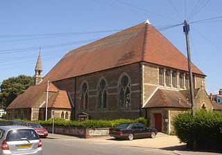
St George's Church is an Anglican church in the East Worthing area of the borough of Worthing, one of seven local government districts in the English county of West Sussex. Built in 1867–68 to serve new residential development in the southeast of the town, the Decorated Gothic-style structure was extended later in the 19th century, and expanded its reach further by founding three mission halls elsewhere in Worthing. English Heritage has listed it at Grade C for its architectural and historical importance.
Rusper Priory was a priory of Benedictine nuns in West Sussex, England.

St John the Baptist's Church is the Church of England parish church of the village of Clayton in Mid Sussex District, one of seven local government districts in the English county of West Sussex. The small and simple Anglo-Saxon building is distinguished by its "remarkable" and extensive set of wall paintings, dating from the early 12th century and rediscovered more than 700 years later. Much of the structural work of the church is 11th-century and has had little alteration. The church, which stands in the middle of a large churchyard and serves the small village of Clayton at the foot of the South Downs, is part of a joint parish with the neighbouring village of Keymer—an arrangement which has existed informally for centuries and which was legally recognised in the 20th century. English Heritage has listed the church at Grade I for its architectural and historical importance.

St Mary Magdalene's Church is the former Anglican parish church of the hamlet of Tortington in the district of Arun, one of seven local government districts in the English county of West Sussex. Founded in the 12th century to serve a priory and villagers in the riverside location, it has experienced little change despite a 19th-century restoration. Its ancient chancel arch and doorway have remarkable carvings with "grotesque, boggle-eyed monsters", rare beakhead figures and chevron ornamentation. Standing in a picturesque setting behind a farm, the flint and Caen stone building was used for worship until 1978, when it was declared redundant. It is now cared for by the Churches Conservation Trust, and English Heritage has listed it at Grade II for its architectural and historical importance. The church is dedicated to Jesus's companion Mary Magdalene.

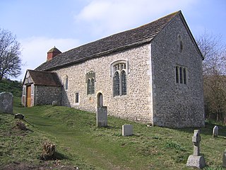
St Botolph's Church is the Church of England parish church of Hardham, West Sussex. It is in Horsham District and is a Grade I listed building. It contains the earliest nearly complete series of wall paintings in England. Among forty individual subjects is the earliest known representation of St George in England. Dating from the 12th century, they were hidden from view until uncovered in 1866 and now "provide a rare and memorable impression of a medieval painted interior". The simple two-cell stone building, with its original medieval whitewashed exterior, has seen little alteration and also has an ancient bell.

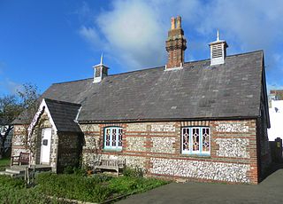
The Elizabeth Almshouses are a collection of four almshouses on Elizabeth Road, Worthing built in 1860 by the architect William Burges. The almshouses were paid for by William's father, Alfred Burges, in memory of Alfred's wife. The building is listed Grade II.
There are more than 130 listed buildings in the town and borough of Eastbourne, a seaside resort on the coast of East Sussex in England. Eastbourne, whose estimated population in 2011 was 99,400, grew from a collection of farming hamlets into a fashionable holiday destination in the mid-19th century; close attention was paid to urban planning and architecture, and the main landowners the Dukes of Devonshire placed restrictions on the types and locations of development. As a result, much of the resort retains its "basic motif" of late Regency and early Victorian houses, hotels and similar buildings, and also has an extensive stock of 19th-century churches. Coastal fortifications have been strategically important for centuries, and structures such as Martello towers and fortresses have survived to be granted listed status. A few older buildings—priories, manor houses and the ancient parish church—are also spread throughout the borough, whose boundaries take in the dramatic cliffs at Beachy Head and its two listed lighthouses.

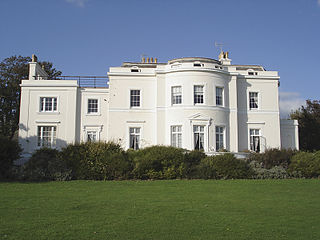
Moulsecoomb Place is a large 18th-century house on Lewes Road in the Moulsecoomb area of the English coastal city of Brighton and Hove. Originally a farmhouse based in an agricultural area in the parish of Patcham, north of Brighton, it was bought and extensively remodelled in 1790 for a long-established local family. It was their seat for over 100 years, but the Neoclassical-style mansion and its grounds were bought by the local council in the interwar period when Moulsecoomb was transformed into a major council estate. Subsequent uses have varied, and Moulsecoomb Place later became part of the University of Brighton's range of buildings. Student housing has been built to the rear; but much of the grounds, the house itself and a much older cottage and barn attached to the rear have been preserved. The house is a Grade II Listed building.

Brickwall House is a country house in Northiam, East Sussex, England, now run as a dyslexia school and also a wedding venue. The timber-framed Tudor house dates to 1617. Brickwall was home to the Frewen family for over three hundred years. The house is a Grade I listed building.
