Related Research Articles

Bretby is a village and civil parish in the south of Derbyshire, England, north of Swadlincote and east of Burton upon Trent, on the border between Derbyshire and Staffordshire. The population of the civil parish as of the 2011 census was 893. The name means "dwelling place of Britons". On the A511 road, there is a secondary settlement, Stanhope Bretby, which was the site of Bretby Colliery.

The A514 road is a road in England. It is a 15-mile (24 km) stretch of single-carriageway road which runs south from Derby city centre (52.9166°N 1.4736°W).

Barrow upon Trent is a village and civil parish in the South Derbyshire district of Derbyshire, England with a business park planned for the outskirts of the village. The village is south of Derby, and between the River Trent and the Trent and Mersey Canal. According to the 2001 census the parish had a population of 546, increasing to 558 at the 2011 Census. Nearby places are Sinfin, Ingleby, Arleston, and Swarkestone.
Boylestone is a village and civil parish in the Derbyshire Dales district of Derbyshire, England. According to the 2001 census it had a population of 165, increasing to 318 at the 2011 Census. The village is situated about eight miles east of Uttoxeter.

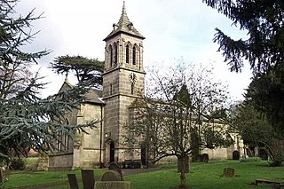
Breadsall is a village and civil parish in the English county of Derbyshire, grid reference SK370397. The population of the civil parish at the 2011 census was 773. Breadsall Priory is nearby.

Creswell railway station serves the village Creswell in Derbyshire, England. The station is on the Robin Hood Line between Nottingham and Worksop. It is also the nearest station to the larger village of Clowne.

Breaston is a large village and civil parish in the Erewash district, in the south-east of Derbyshire in the East Midlands of England near Long Eaton and close to the M1. The population of the civil parish as taken at the 2011 Census was 4,455.

Brailsford is a small red-brick village and civil parish in Derbyshire on the A52 midway between Derby and Ashbourne. The civil parish population at the 2011 Census was 1,118. The village has a pub, a golf club, a post office and a school. There are many fine houses in the district including two 20th-century country houses: Brailsford Hall built in 1905 in Jacobean style, and Culland Hall.

Boylestone is a village in Derbyshire, England.

Burnaston is a village and civil parish in the South Derbyshire district of Derbyshire, England. It is about 4.5 miles (7.2 km) southwest of the city of Derby and has a population of 1,531. It contains the headquarters and vehicle manufacturing plant of Toyota Manufacturing UK, built on the site of the former Derby Airport.

Hemington is a village in Leicestershire, England.

Church Broughton is a village and civil parish in Derbyshire, 13.7 miles (22.0 km) to the west of Derby. It has a church and a Methodist chapel (1828). Badway Green is a piece of common land within the parish. It is an isolated village surrounded by farmland.

Cauldwell is a small village and civil parish in South Derbyshire. Its streets are named Main Street, Church Lane and Sandy Lane. It has a school for children with special needs.

Uttoxeter Road is a cricket ground located along the Uttoxeter Road between the villages of Lower Tean and Checkley in Staffordshire. The ground is surrounded on all sides by countryside.
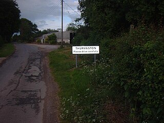
Thurvaston is a small village in South Derbyshire. In 1970 the population was put at 200. This represents a general fall since 1871 when the population was just below 400. As at the census 2011 the population is now listed in the civil parish of Osleston and Thurvaston.

West Hallam railway station was a railway station located between the villages of Stanley and West Hallam in Derbyshire, England. It was opened by the Great Northern Railway on its Derbyshire Extension in 1878.

Lockington is a village in the Leicestershire parish of Lockington-Hemington. The village is close to the Derbyshire border. The population at the 2011 census was included in the civil parish of Lockington-Hemington.
Harehills is an inner-city area of east Leeds, West Yorkshire England.
St John Houghton Catholic Voluntary Academy is a mixed Roman Catholic secondary school located in Kirk Hallam in the English county of Derbyshire. The school is named after Saint John Houghton, a Carthusian hermit and Catholic priest who was the first English Catholic martyr to die as a result of the Act of Supremacy by King Henry VIII of England.
Boylestone is a civil parish in the Derbyshire Dales district of Derbyshire, England. The parish contains six listed buildings that are recorded in the National Heritage List for England. Of these, one is listed at Grade II*, the middle of the three grades, and the others are at Grade II, the lowest grade. The parish contains the village of Boylestone and the hamlet of Harehill, and the surrounding countryside. The listed buildings consist of two houses, a church, a public house, a farmhouse, and a vicarage converted into a private house and an associated water pump.
References
Philip's Street Atlas Derbyshire (page 213) Coordinates: 52°55′00″N1°44′28″W / 52.9166°N 1.7412°W
| Wikimedia Commons has media related to Harehill . |
| | This Derbyshire location article is a stub. You can help Wikipedia by expanding it. |