Hayswood Nature Reserve

Last updated
Park Entrances Hayswood nature reserve sign1.jpg
Park Entrances

The Hayswood Nature Preserve is a county park owned by the Harrison County, Indiana Park and Recreation Board.

Harrison County, Indiana County in the United States

Harrison County is located in the far southern part of the U.S. state of Indiana along the Ohio River. The county was officially established in 1808. As of the 2010 census, the county's population was 39,364, an increase of 6.6% from 2000. The county seat is Corydon, the former capital of Indiana.

Contents

The Samuel P. Hays donation

Duck Pond Hayswood park3.jpg
Duck Pond

The preserve was donated to the citizens of Harrison County in 1969 by Samuel P. Hays, A Corydon native and Professor Emeritus of History at the University of Pittsburgh. [1] The parks board developed a portion of the land in 1973 for public use, but the majority of the land remains in its original condition to be preserved for the future. Although the entire park is open to the public, the nature reserve area is to always kept free of development to continue Hays' dream of natural preservation of the land. [2]

Samuel Pfrimmer Hays was a pioneering environmental, social and political historian. Born in Corydon, Indiana and raised on a local dairy farm. He earned a graduates degree from Swarthmore College in 1948, and a Ph.D. at Harvard University. He authored multiple works including "The Response to Industrialism 1885-1914" in 1957, "Conservation and the Gospel of Efficiency," "Beauty, Health, and Permanence: Environmental Politics in the United States, 1955-1985” and "A History of Environmental Politics since 1945". He established the Archives of Industrial Society at Pittsburgh University, where he served as a professor from 1960 until 1990.

University of Pittsburgh American state-related research university located in Pittsburgh, Pennsylvania

The University of Pittsburgh is a state-related research university in Pittsburgh, Pennsylvania. It was founded as the Pittsburgh Academy in 1787 on the edge of the American frontier. It developed and was renamed as Western University of Pennsylvania by a change to its charter in 1819. After surviving two devastating fires and various relocations within the area, the school moved to its current location in the Oakland neighborhood of the city; it was renamed as the University of Pittsburgh in 1908. Pitt was a private institution until 1966 when it became part of the Commonwealth System of Higher Education.

The park property has a history as interesting as its nature. The property was previously owned by Henry L. Fabrique. In 1820 he constructed a water mill in the curve of Indian Creek. He later sold the mill to John Peter Mauck, the founder of Mauckport, whose family operated the mill until the advent of electricity in the 1920s. The same mill was one of many threatened with burning by Confederate General John Hunt Morgan after the Battle of Corydon. [2]

Mauckport, Indiana Town in Indiana, United States

Mauckport is a town in Heth Township, Harrison County, Indiana, along the Ohio River. The population was 81 at the 2010 census.

John Hunt Morgan Confederate Army general

John Hunt Morgan was a Confederate general in the American Civil War.

Battle of Corydon

The Battle of Corydon was a minor engagement that took place July 9, 1863, just south of Corydon, which had been the original capital of Indiana until 1825, and was the county seat of Harrison County. The attack occurred during Morgan's Raid in the American Civil War as a force of 2,500 cavalry invaded the North in support of the Tullahoma Campaign. It was the only pitched battle of the Civil War that occurred in Indiana, and no battle has occurred within Indiana since.

Park area

Big Indian Creek flows along the southern edge of the park Haywood park4.jpg
Big Indian Creek flows along the southern edge of the park

This park preserve covers 311 acres (1.26 km2) and includes the Pilot Knob, the surrounding forest, and several rock outcrops overlooking Indian Creek that runs along the eastern side of the park. The forest consists largely of oak-hickory forest with beech-maple forest closer to the creek. [3]

The park has a paved looped hiking trail along the north part of the park. There is a large playground on the western side, a fishing lake near the creek, primitive restrooms, and picnic areas. The Doolittle section of the Indian Creek Trail passes through the park and features a walking bridge over the creek.

See also

Related Research Articles

Corydon, Indiana Town in Indiana, United States

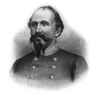
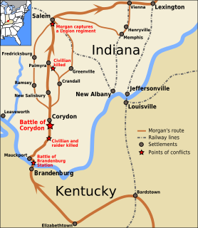
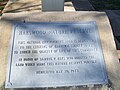
Corydon is a town in Harrison Township, Harrison County, Indiana. Located north of the Ohio River in the extreme southern part of the U.S. state of Indiana, it is the seat of government for Harrison County. Corydon was founded in 1808 and served as the capital of the Indiana Territory from 1813 to 1816. It was the site of Indiana's first constitutional convention, which was held June 10–29, 1816. Forty-three convened to consider statehood for Indiana and drafted its first state constitution. Under Article XI, Section 11, of the Indiana 1816 constitution, Corydon was designated as the capital of the state until 1825, when the seat of state government was moved to Indianapolis. During the American Civil War, Corydon was the site of the Battle of Corydon, the only official pitched battle waged in Indiana during the war. More recently, the town's numerous historic sites have helped it become a tourist destination. A portion of its downtown area is listed in the National Register of Historic Places as the Corydon Historic District. As of the 2010 census, Corydon had a population of 3,122.

Crandall, Indiana Town in Indiana, United States

Crandall is a town in Jackson Township, Harrison County, Indiana, United States. The population was 152 at the 2010 census.

McCormicks Creek State Park

McCormick's Creek State Park is the oldest state park in the U.S. state of Indiana, dedicated on July 4, 1916, as part of the state's centennial celebration. It is located 14 miles (23 km) west of Bloomington in Owen County.

Shades State Park

Shades State Park is a state park in Montgomery, Parke, and Fountain Counties in Indiana. It is located 47 miles (76 km) west-northwest of Indianapolis, Indiana.

Mountains-to-Sea Trail

The Mountains-to-Sea State Trail (MST) is a long-distance trail for hiking and backpacking, that traverses North Carolina from the Great Smoky Mountains to the Outer Banks. The trail's western endpoint is at Clingman's Dome, where it connects to the Appalachian Trail in the Great Smoky Mountains National Park. Its eastern endpoint is in Jockey's Ridge State Park on the tallest sand dune on the east coast. The trail is envisioned as a scenic backbone of an interconnected trail system spanning the state. As such, the trail's route attempts to connect as many trail systems and natural scenic areas as practicable. A little over half of the trail is complete in multiple segments across the state.

Arch Creek, Florida early settlement near Miami, Florida, USA

Arch Creek was an early settlement in Miami-Dade County, Florida, in present-day metropolitan Miami. Tequesta Indians thrived here before the first Europeans arrived in the early 16th century. The name is derived from the natural limestone bridge spanning 40 feet (12 m) across the creek. It is part of the Arch Creek Memorial Park at 1855 Northeast 135th Street, on Biscayne Boulevard. It was added to the U.S. National Register of Historic Places on July 15, 1986.

Western Pennsylvania Conservancy non-profit organisation in the USA

The Western Pennsylvania Conservancy (WPC) is a private nonprofit conservation organization founded in 1932 and headquartered in Pittsburgh, PA. WPC has contributed land to 12 state parks and conserved more than a quarter million acres of natural lands. The Conservancy plants and maintains more than 132 gardens in 20 Western Pennsylvania counties, as well as planting thousands of trees through its community forestry program. WPC has protected or restored more than 3,000 miles (4,800 km) of rivers and streams. In 1963, Edgar Kaufmann Jr. entrusted Frank Lloyd Wright's masterwork Fallingwater to the Conservancy. The house was called the most important building of the 20th century by the American Institute of Architects.

The Office of Kentucky Nature Preserves is an agency of the Commonwealth of Kentucky in the United States dedicated to the protection of Kentucky's natural heritage. It oversees a statewide program of nature preserves, Kentucky Wild Rivers Program, and the "Nature's Finest" license plate program of the Kentucky Heritage Land Conservation Fund Board. The program was formerly known as the "Kentucky State Nature Preserves Commission", from 1976 until a reorganization in 2018.

Harrison Township, Harrison County, Indiana Township in Indiana, United States

Harrison Township is one of twelve townships in Harrison County, Indiana, United States. As of the 2010 census, its population was 12,484 and it contained 5,282 housing units. Corydon, the county seat of Harrison County, is in Harrison Township.

Pilot Knob, Indiana Unincorporated community in Indiana, United States

Pilot Knob is an unincorporated community in Jennings Township, Crawford County, Indiana.

Muscatatuck County Park, formerly known as Vinegar Mills State Park and Muscatatuck State Park, is a recreational park located by the town of Vernon, Indiana in Jennings County.

Autrey Mill Nature Preserve & Heritage Center

The Autrey Mill Nature Preserve & Heritage Center is located in Johns Creek, Georgia, U.S.A.

Parks and Greenways in Huntsville

An extension collection of parks and greenways exists in Huntsville, Alabama for the public's recreational use.

Corydon Junction is an unincorporated community in Harrison County, Indiana, in the United States.

References

Coordinates: 38°12′29″N86°08′35″W / 38.208°N 86.143°W / 38.208; -86.143

Geographic coordinate system Coordinate system

A geographic coordinate system is a coordinate system that enables every location on Earth to be specified by a set of numbers, letters or symbols. The coordinates are often chosen such that one of the numbers represents a vertical position and two or three of the numbers represent a horizontal position; alternatively, a geographic position may be expressed in a combined three-dimensional Cartesian vector. A common choice of coordinates is latitude, longitude and elevation. To specify a location on a plane requires a map projection.