
East Hertfordshire is a local government district in Hertfordshire, England. The main settlement is Bishop's Stortford.

The Diocese of St Albans forms part of the Province of Canterbury in England and is part of the wider Church of England, in turn part of the worldwide Anglican Communion.
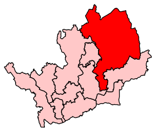
North East Hertfordshire is a constituency represented in the House of Commons of the UK Parliament since 1997 by Oliver Heald, a Conservative.
Bayford is a village and civil parish in the East Hertfordshire district of Hertfordshire, England. According to the 2001 census it had a population of 435, increasing to 466 at the 2011 Census. The village is about three miles south of Hertford, and is served by Bayford railway station.
Bengeo Rural is a civil parish in the East Hertfordshire district of Hertfordshire, England. According to the 2001 census it had a population of 601, increasing at the 2011 Census to 644. The parish includes the villages of Tonwell and Chapmore End.

East Hertfordshire District Council is the local authority for the East Hertfordshire non-metropolitan district of England, the United Kingdom. East Hertfordshire covers most of the eastern third of Hertfordshire, in the East of England region. The Council itself is based in Bishop's Stortford, the largest settlement in the district, with a secondary council office in Hertford, the county town.
The A602 is a road linking Hitchin in Hertfordshire, England, with A10 at Ware in Hertfordshire, via Stevenage.

Hertford Heath is a small village and civil parish near the county town of Hertford in Hertfordshire, England. The population at the 2011 Census was 2,672.

The Kingsmead Viaduct is a raised dual-carriageway viaduct of the A10 road on the eastern outskirts of Ware, Hertfordshire, England. It carries the A10 over the River Lea, the New River and the Hertford East railway.

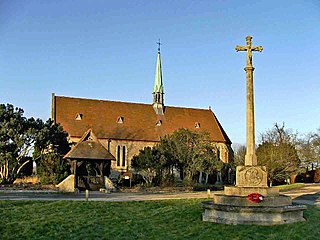
The Church of Saint Leonard is a Norman church in Bengeo, Hertfordshire. Located on the hillside overlooking the shared Beane and Lea valley, the Grade I Listed church dates from about 1120, and is the oldest building in Hertford. The church served as the parish church of Bengeo until the larger Holy Trinity Church was opened in 1855. St. Leonard's was stripped of its fittings and stood empty and unused for some years, until the Gosselin family of nearby Bengeo Hall commissioned its restoration and refitting between 1884 and 1894.
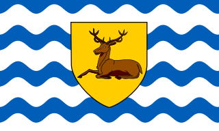
The flag of Hertfordshire is the flag of the English county of Hertfordshire. The flag is a banner of the arms of Hertfordshire County Council. On 19 November 2008 the Council passed a resolution that the design is a fitting and proper emblem for the county and its people. The council subsequently registered the banner of arms as the flag of the county with the Flag Institute and it now appears on the latter's registry of local flags.

Hertford Museum is a local museum in Hertford, the county town of Hertfordshire, England.

Balls Park in Hertford is a Grade I Listed mid-17th-century house. The estate and house are set in over 63 acres of parkland which is listed Grade II on the English Heritage Register of Parks and Gardens of Special Historic Interest. The estate and house are believed to have been the inspiration for some of Jane Austen’s novel Pride and Prejudice, which is set in Hertfordshire.

Bramfield is a village and civil parish in the East Hertfordshire district, in the county of Hertfordshire, England. Nearby settlements include Hertford, Waterford and Stapleford. Bramfield has a church dedicated to St Andrew.

Aston Bury is a manor house near Aston, Hertfordshire, England. It is Grade I listed building.
St Mary's Church of England High School is a mixed secondary school and sixth form located in Cheshunt, Hertfordshire, England. It is a Church of England school under the direction of the Diocese of St Albans.

Youngsbury House is a Grade II listed house near Wadesmill, Hertfordshire, England. The stable block is Grade II* listed.

The Court House, sometimes known as the Old Town Hall, is a 19th-century building in St Albans, Hertfordshire, England. It no longer serves a judicial function. In 2018 the local museum, which had been closed for some years, was rehoused in the building.

The Shire Hall in Hertford, the county town of Hertfordshire, England, is an 18th-century building. It was designed to provide assembly rooms, courts and a council chamber. It also housed the town's corn exchange until the mid-nineteenth century. It was proposed as a joint project by Robert Adam and his younger brother James Adam, but James took charge of the commission and the design is credited to him. Built around 1768–9, the building was expanded several times in subsequent years.

The County Hall is a municipal building complex in Hertford, Hertfordshire, that is the seat of Hertfordshire County Council.


