
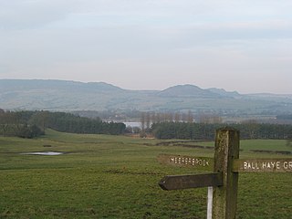
The Peak District is an upland area in England, at the southern end of the Pennines. Mostly in Derbyshire, it extends into Cheshire, Greater Manchester, Staffordshire, West Yorkshire and South Yorkshire. It is subdivided into the Dark Peak, moorland dominated by gritstone, and the White Peak, a limestone area with valleys and gorges. The Dark Peak forms an arc on the north, east and west of the district, and the White Peak covers central and southern areas. The highest point is Kinder Scout. Most of the area is within the Peak District National Park, a protected landscape designated in 1951.

Derbyshire is a ceremonial county in the East Midlands of England. It borders Greater Manchester, West Yorkshire, and South Yorkshire to the north, Nottinghamshire to the east, Leicestershire to the south-east, Staffordshire to the south and west, and Cheshire to the west. Derby is the largest settlement, and Matlock is the county town.

The Pennines, also known as the Pennine Chain or Pennine Hills, are a range of uplands mainly located in Northern England. Commonly described as the "backbone of England" because of its length and position, the range runs from the north Midlands to North East England, near the Anglo-Scottish border. The Peak District is the southern end of the range, rising northwards from its foothills near the Trent Valley in northern Staffordshire, and further north into eastern Cheshire and southern Derbyshire. Beyond this are the South Pennines, Yorkshire Dales, and North Pennines, ending at the Tyne Gap. Beyond the gap are the Border Moors and Cheviot Hills, which are included in some definitions of the range.

High Peak is a local government district with borough status in Derbyshire, England, covering a high moorland plateau in the Dark Peak area of the Peak District National Park. The district stretches from Holme Moss in the north to Sterndale Moor in the south, and from Hague Bar in the west to Bamford in the east. The population of the borough taken at the 2011 Census was 90,892. The borough is unusual in having two administrative centres for its council, High Peak Borough Council; the offices are in Buxton and Glossop. Other towns include Chapel-en-le-Frith, Hadfield, New Mills and Whaley Bridge.
Staffordshire Moorlands is a local government district in Staffordshire, England. Its council is based in Leek, the district's largest town. The district also contains the towns of Biddulph and Cheadle, along with a large rural area containing many villages. North-eastern parts of the district lie within the Peak District National Park.

The Dark Peak is the higher and wilder part of the Peak District in England, mostly forming the northern section but also extending south into its eastern and western margins. It is mainly in Derbyshire but parts are in Staffordshire, Cheshire, Greater Manchester, West Yorkshire and South Yorkshire.
Bleaklow is a high, largely peat-covered, gritstone moorland in the Derbyshire High Peak near the town of Glossop. It is north of Kinder Scout, across the Snake Pass (A57), and south of the A628 Woodhead Pass. Much of it is nearly 2,000 feet (610 m) above sea level and the shallow bowl of Swains Greave on its eastern side is the source of the River Derwent.
Winter Hill is a hill on which the three boroughs of Chorley, Blackburn with Darwen and Bolton meet in North West England. It is located on Rivington Moor, Chorley and is 1,496 feet (456 m) high. Part of the West Pennine Moors, it is a popular walking area, and has been the site of mining activity, aeroplane disasters and murders.

Alston Moor, formerly known as Alston with Garrigill, is a civil parish and electoral ward in the Westmorland and Furness district, in the ceremonial county of Cumbria, England, based around the small town of Alston. It is set in the moorlands of the North Pennines, mostly at an altitude of over 1000 feet. The parish/ward had a population of 2,088 at the 2011 census. As well as the town of Alston, the parish includes the villages of Garrigill and Nenthead, along with the hamlets of Nenthall, Nentsberry, Galligill, Blagill, Ashgill, Leadgate, Bayles and Raise. Alston Moor is part of the North Pennines Area of Outstanding Natural Beauty (AONB), the second largest of the 40 AONBs in England and Wales.

The Manifold Way is a footpath and cycle way in Staffordshire, England. Some 8 miles (13 km) in length, it runs from Hulme End (53.1307°N 1.8480°W) in the north to Waterhouses (53.0480°N 1.8654°W) in the south, mostly through the Manifold Valley and the valley of its only tributary, the River Hamps, following the route of the former Leek and Manifold Valley Light Railway, a 2 ft 6 in gauge line which closed in 1934 after a short life.

Derwent Edge is a Millstone Grit escarpment that lies above the Upper Derwent Valley in the Peak District National Park in the English county of Derbyshire. An Ordnance Survey column marks the highest point of the Edge at Back Tor. North of Back Tor the edge extends into Howden Edge and enters the county of South Yorkshire.

Longshaw Estate is an area of moorland, woodland and farmland within the Peak District National Park in Derbyshire, England.
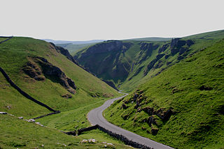
Winnats Pass is a hill pass and limestone gorge in the Peak District of Derbyshire, England. The name is a corruption of 'wind gates' due to the swirling winds through the pass. It lies west of the village of Castleton, in the National Trust's High Peak Estate and the High Peak borough of Derbyshire. The road winds through a cleft, surrounded by high limestone ridges. At the foot of the pass is the entrance to Speedwell Cavern, a karst cave accessed through a flooded lead mine, and which is a popular tourist attraction.

The Marsden Moor Estate is a large expanse of moorland in the South Pennines, between the conurbations of West Yorkshire and Greater Manchester in the north of England. It is named after the adjacent town of Marsden, and is owned and administered by the National Trust to whom it was conveyed in 1955 by the Radcliffe family in lieu of death duties.

The South Pennines is a region of moorland and hill country in northern England lying towards the southern end of the Pennines. In the west it includes the Rossendale Valley and the West Pennine Moors. It is bounded by the Greater Manchester conurbation in the west and the Bowland Fells and Yorkshire Dales to the north. To the east it is fringed by the towns of West Yorkshire whilst to the south it is bounded by the Peak District. The rural South Pennine Moors constitutes both a Site of Special Scientific Interest and Special Area of Conservation.
Esclusham Mountain is an area in Wrexham County Borough, Wales, United Kingdom, and is part of the Ruabon Moors. It rises to a height of 460 m, with the nearby spur of Cyrn-y-Brain, to the west, reaching 473 m. It lies mostly within the community of Esclusham. A smaller spur to the north, known as Minera Mountain, is within the neighbouring community of Minera.

Brown Knoll is one of the highest hills in the Peak District in central England. It rises to a height of 569 metres (1,867 ft) above the head of the Edale valley and about 3 kilometres (1.9 mi) south-southwest of the Peak's highest point, Kinder Scout.

Totley Moor is an open moorland hill to the west of the Sheffield suburb of Totley, in the Derbyshire Peak District. The summit is 395 metres (1,296 ft) above sea level.

Bradwell Moor is a moorland hill above the village of Bradwell, Derbyshire in the Peak District. The summit is 471 metres (1,545 ft) above sea level.

Jacob's Ladder is a bridleway between Kinder Scout plateau and the hamlet of Upper Booth in the Vale of Edale, in the Derbyshire Peak District of England.

