
The Karwendel is the largest mountain range of the Northern Limestone Alps. It is located on the Austria–Germany border. The major part belongs to the Austrian federal state of Tyrol, while the adjacent area in the north is part of Bavaria, Germany. Four chains stretch from west to east; in addition, there are a number of fringe ranges and an extensive promontory (Vorkarwendel) in the north.

Zofingen is a city in the canton of Aargau in Switzerland. It is the capital of the district of Zofingen. Zofingen is a walled city and home of an ancient monastic settlement.

Heroldstatt is a village in the district of Alb-Donau in Baden-Württemberg in Germany.

Hirrlingen is a municipality in the district of Tübingen in Baden-Württemberg in Germany. Hirrlingen is located about 15 kilometers southwest from Tübingen.

The Uri Alps are a mountain range in Central Switzerland and part of the Western Alps. They extend into the cantons of Obwalden, Valais, Bern, Uri and Nidwalden and are bordered by the Bernese Alps and the Emmental Alps to the west, the Schwyzer Alps to the north, the Lepontine Alps to the south and the Glarus Alps to the east (Reuss).
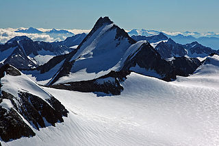
Hintere Schwärze is a mountain on the border between Austria and Italy. At 3,628 metres (11,903 ft), it is the fourth highest peak in the Ötztal Alps.
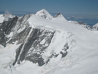
Hinteres Fiescherhorn is a summit of the Bernese Alps and build together with Grosses and Kleines Fiescherhorn the Fiescherhörner. It is located in the Swiss canton of Valais near the border with the canton of Berne. The southern rock-tower pt 3,981 m (13,061 ft) is a prominent sub-peak.

The County of Sponheim was an independent territory in the Holy Roman Empire that lasted from the 11th century until the early 19th century. The name comes from the municipality of Sponheim, where the counts had their original residence.

The Hintere Schöntaufspitze is a mountain in the Ortler Alps in South Tyrol, Italy.
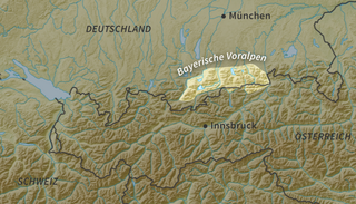
The Bavarian Prealps are a mountain range within the Northern Limestone Alps along the Austria–Germany border. They include the Bavarian Prealp region between the river Loisach to the west and the river Inn to the east; the range is about 80 kilometres (50 mi) long and 20–30 kilometres (12–19 mi) wide. The term is not defined politically, but alpine-geographically because, although the range is mostly located in Bavaria, southeast Germany, small areas of the Bavarian Prealps lie in the state of Tyrol, Austria.

The Seefelder Aach is a river in the districts of Sigmaringen and Bodenseekreis, Tübingen region, southern Baden-Württemberg, Germany. It is approximately 55 kilometres long and flows into Lake Constance. It has a catchment area of 279 km2 and is part of the Rhine river system. It starts as Salemer Aach and becomes the Seefelder Aach after the conjunction with the Deggenhauser Aach, further down from Salem. The upper part – near Aach-Linz – it is also colloquially called Linzer Aach or Hintere Aach.
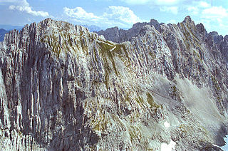
The Hintere Bachofenspitze in the Karwendel mountains of Tyrol is 2,668 metres (8,753 ft) high and forms the northernmost point of the parish of Thaur in the Inn Valley. Since the erection of a summit cross, that was set up in October 2003 by Franz Brunner and Fritz Gostner, this summit has enjoyed growing popularity.
The Goinger Halt is a mountain in the Kaisergebirge range in the Northern Limestone Alps in Austria. It has a double summit: a northern top to the rear, the Hintere Goinger Halt, and a higher, southern top in front, the Vordere Goinger Halt. The name "Halt" means something like Alpine meadow and refers therefore to the peak over the meadow areas, that belong to the parish of Going.

The Karlspitzen is a twin-peaked mountain in the middle of the Kaisergebirge range of the Northern Limestone Alps in Austria. The two peaks are the northern Hintere Karlspitze and the southern Vordere Karlspitze with its summit cross; they are linked by a sharp, exposed, rocky arête. Seen from the south the Vordere Karlspitze is a huge and very prominent block of rock, whereas the Hintere Karlspitze is hidden behind other (lower) neighbouring mountains.

Vorstadt was a quarter of southern Königsberg, Germany. Its territory is now part of the Moskovsky District of Kaliningrad, Russia.
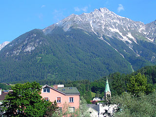
The Vordere Brandjochspitze is a peak, 2,559 m (AA) high, in the Nordkette in the Karwendel range and is one of its highest and most striking peaks. In its immediate vicinity to the north-northwest is its sister summit, the Hintere Brandjochspitze, which is about 40 metres higher. To the south a prominent arête runs over to the Brandjochkreuz and the Achselkopf and down to the Innsbruck quarter of Hötting. To the east, the main ridge of the Nordkette runs over to Frau Hitt.

On the island of Lindau in the eastern Lake Constance is the Altstadt of the Bavarian county town of Lindau, which occupies the eastern part of the island. The island of Lindau, which forms 2% of the area and 12% of the population of the entire town, is one of the town's ten administrative districts. The district is just called Insel ("Island").

The Hinterer Tajakopf is a mountain, 2,408 metres high, in the Mieming Range in the Austrian state of Tyrol.

