Related Research Articles

Huntingdonshire is a local government district in Cambridgeshire, England, which was historically a county in its own right. It borders Peterborough to the north, Fenland to the north-east, East Cambridgeshire to the east, South Cambridgeshire to the south-east, Central Bedfordshire and Bedford to the south-west, and North Northamptonshire to the west.
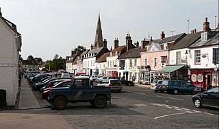
Kimbolton is a town and civil parish in the Huntingdonshire district of Cambridgeshire, England. Kimbolton is about 9 miles (14 km) west of Huntingdon and 14 miles (23 km) north of Bedford.
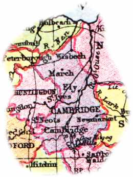
The English county of Cambridgeshire has a long history.

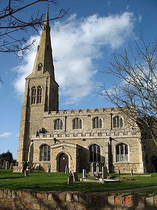
Hemingford Grey is a village and civil parish in Cambridgeshire, England. Hemingford Grey lies approximately 4 miles (6 km) east of Huntingdon. Hemingford Grey is situated within Huntingdonshire which is a non-metropolitan district of Cambridgeshire as well as being a historic county of England.

Molesworth is a village and former civil parish, now in the parish of Brington and Molesworth in Cambridgeshire, England, historically in the county of Huntingdonshire. Molesworth is 10 miles (16 km) north-west of Huntingdon. The neighbouring village of Brington is 0.7 miles (1.1 km) from Molesworth. Molesworth is situated within Huntingdonshire which is a non-metropolitan district of Cambridgeshire as well as being a historic county of England. In 1931 the parish had a population of 114. The civil parish of Brington and Molesworth covers an area of 2,842 acres. Just to the north of Molesworth and within the civil parish is RAF Molesworth. The village of Molesworth was designated a conservation area by Huntingdon District Council largely due to its typically rural English character that includes several listed buildings.

Bythorn is a village and former civil parish, now in the parish of Bythorn and Keyston, in Cambridgeshire, England. Bythorn lies approximately 11 miles (18 km) west of Huntingdon near Molesworth. Bythorn is situated within Huntingdonshire which is a non-metropolitan district of Cambridgeshire as well as being a historic county of England. In 1931 the parish had a population of 129.

Keyston is a village and former civil parish, now in the parish of Bythorn and Keyston, in Cambridgeshire, England. Keyston lies approximately 12 miles (19 km) west of Huntingdon, near Molesworth. Keyston is situated within Huntingdonshire which is a non-metropolitan district of Cambridgeshire as well as being a historic county of England. In 1931 the parish had a population of 151.
Great Paxton is a village and civil parish in Cambridgeshire, England. It is in Huntingdonshire which is a non-metropolitan district of Cambridgeshire as well as being a historic county of England. The village lies 2.6 miles (4.2 km) north of St Neots in the Great Ouse river valley.

Hemingford Abbots is a village and civil parish in Cambridgeshire, England. Hemingford Abbots lies approximately 3 miles (5 km) east of Huntingdon, and is almost continuous with neighbouring Hemingford Grey. Hemingford Abbots is situated within Huntingdonshire which is a non-metropolitan district of Cambridgeshire as well as being a historic county of England.

Old Weston – in Huntingdonshire, England – is a village near Molesworth west of Huntingdon.
Catworth is a village and civil parish in Cambridgeshire, England. Catworth lies approximately 9 miles (14 km) west of Huntingdon. The civil parish covers an area of 3,094 acres. Catworth village has two parts, Catworth, at the top of the hill, and Little Catworth, at the bottom. Catworth is situated within Huntingdonshire which is a non-metropolitan district of Cambridgeshire as well as being a historic county of England.

Covington is a village and civil parish in Cambridgeshire, England. Covington lies approximately 10 miles (16 km) west of Huntingdon near to Catworth and close to the county borders with both Bedfordshire and Northamptonshire. Covington is situated within Huntingdonshire which is a non-metropolitan district of Cambridgeshire as well as being a historic county of England. Covington. The civil parish covers an area of 1,294 acres. At the 2011 Census the population of the village was found to be less than 100 and was included in the civil parish of Tilbrook.

Grafham is a village and civil parish in Cambridgeshire, England. The village lies approximately 5 miles (8 km) south-west of Huntingdon. Grafham is situated within Huntingdonshire which is a non-metropolitan district of Cambridgeshire as well as being a historic county of England. The village gives its name to the nearby reservoir, Grafham Water. The village recently successfully raised funds as a community venture and via external funding sources to open a community convenience store located in the grounds of the village hall.

Hail Weston is a village and civil parish in Cambridgeshire, England. Hail Weston lies approximately 7 miles (11 km) south of Huntingdon. Hail Weston is situated within Huntingdonshire which is a non-metropolitan district of Cambridgeshire as well as being a historic county of England.
Ellington is a village and civil parish in Cambridgeshire, England, 4 miles (6 km) west of Huntingdon in Huntingdonshire, a non-metropolitan district of Cambridgeshire and historic county of England. The civil parish covers an area of 2,700 acres ; much of it is grassland with some small woods in the south of the parish.

Woolley is a hamlet and former civil parish, now in the parish of Barham and Woolley, in Cambridgeshire, England. Woolley lies approximately 5 miles (8 km) west of Huntingdon. The hamlet is in Huntingdonshire, which is a non-metropolitan district of Cambridgeshire as well as being a historic county of England. In 1931 the parish had a population of 29.

Brington is a village and former civil parish, now in the parish of Brington and Molesworth, in Cambridgeshire, England. Brington lies approximately 9 miles (14 km) north-west of Huntingdon. Brington is situated within Huntingdonshire which is a non-metropolitan district of Cambridgeshire as well as being a historic county of England. In 1931 the parish had a population of 75.
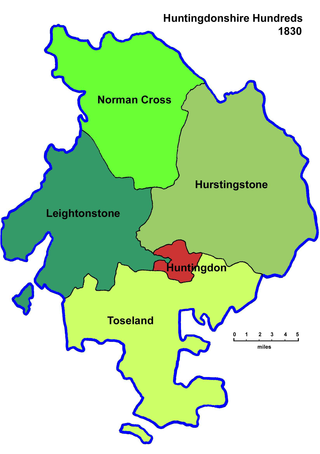
Between Anglo-Saxon times and the nineteenth century Huntingdonshire was divided for administrative purposes into 4 hundreds, plus the borough of Huntingdon. Each hundred had a separate council that met each month to rule on local judicial and taxation matters.

Leightonstone was a hundred of Huntingdonshire mentioned in the Domesday Book of 1086. It took its name from the stone at Leighton Bromswold where the area's moot was held. In modern times it was an ecclesiastical administrative area within the Diocese of Ely.
Hurstingstone was a hundred of Huntingdonshire, England that was mentioned in the Domesday Book of 1086.
References
This article incorporates text from a publication now in the public domain : Chisholm, Hugh, ed. (1911). "Huntingdonshire". Encyclopædia Britannica . Vol. 13 (11th ed.). Cambridge University Press. pp. 951–953.