Polk County is a county located in the southeastern corner of the U.S. state of Tennessee. As of the 2020 United States census, its population was 17,544. Its county seat is Benton. The county was created on November 28, 1839, from parts of Bradley and McMinn counties, after final removal of most Cherokee from the region that year. The county was named after then-governor James K. Polk. Polk County is included in the Cleveland, Tennessee Metropolitan Area Statistical Area, which is also included in the Chattanooga–Cleveland–Dalton, TN–GA–AL Combined Statistical Area.

Fannin County is a county located in the north central portion of the U.S. state of Georgia. As of the 2020 census, the population was 25,319. It is one of the most rural counties in Georgia due its location in the Appalachian Mountain Range, with about 90% of the population of Fannin County living in unincorporated lands. The county seat is Blue Ridge. The county was created on January 21, 1854, and is named after James Fannin, a veteran who fought in the Texas Revolution.

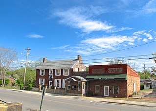
Charleston is a city in Bradley County, Tennessee, United States. The population was 664 at the 2020 census. It is included in the Cleveland Metropolitan Statistical Area.
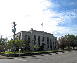
Benton is a town in Polk County, Tennessee, United States. The population was 1,532 at the 2020 census. It is the county seat.

Copperhill is a city in Polk County, Tennessee, United States. The population was 443 at the 2020 census. It is included in the Cleveland Metropolitan Statistical Area.

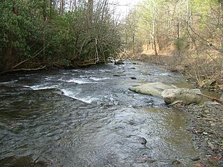
The Toccoa River and Ocoee River are the names in use for a single 93-mile-long (150 km) river that flows northwestward through the southern Appalachian Mountains of the southeastern United States. It is a tributary of the Hiwassee River, which it joins in Polk County, Tennessee, near the town of Benton. Three power generating dams are operated along it.
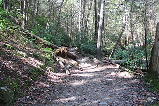
The North River of Tennessee is a major tributary of the Tellico River. It rises in the Unicoi Range, which are geologically related to the Smoky Mountains to the north, in Monroe County, Tennessee inside Cherokee National Forest. Its entire course is located in a very scenic, very isolated area; for the vast majority of its length it is parallel by Forest Road 217, also called North River Road, managed by the Forest Service of the United States Department of Agriculture. It flows very roughly east to west. There is a Forest Service campground located near its confluence with the Tellico, which is located upstream and opposite that of the Tellico's other major tributary, the Bald River.

The Hiwassee River originates from a spring on the north slope of Rocky Mountain in Towns County in the northern area of the State of Georgia. It flows northward into North Carolina before turning westward into Tennessee, flowing into the Tennessee River a few miles west of what is now State Route 58 in Meigs County, Tennessee. The river is about 147 miles (237 km) long.

The Tennessee Valley Railroad Museum is a railroad museum and heritage railroad in Chattanooga, Tennessee.
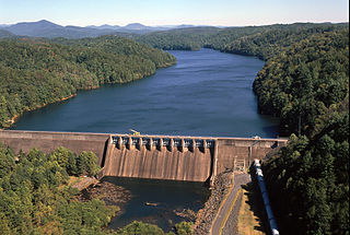
Apalachia Dam is a hydroelectric dam on the Hiwassee River in Cherokee County, in the U.S. state of North Carolina. The dam is the lowermost of three dams on the river owned and operated by the Tennessee Valley Authority, which built the dam in the early 1940s to provide emergency power for aluminum production during World War II. While the dam is in North Carolina, an 8.3-mile (13.4 km) underground conduit carries water from the dam's reservoir to the powerhouse located 12 miles (19 km) downstream across the state line in Polk County, Tennessee. The dam and associated infrastructure were listed on the National Register of Historic Places in 2017.

Overhill Cherokee was the term for the Cherokee people located in their historic settlements in what is now the U.S. state of Tennessee in the Southeastern United States, on the western side of the Appalachian Mountains. This name was used by 18th-century European traders and explorers from British colonies along the Atlantic coast, as they had to cross the mountains to reach these settlements.
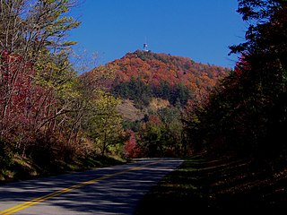
Chilhowee Mountain is the name of two non-contiguous low ridges in the U.S. state of Tennessee. The northern section is at the outer edge of the Great Smoky Mountains, stretching between the Little Tennessee River and Chilhowee Dam to the west, and the Little Pigeon River watershed to the east. The southern section is within the outer edge of the Unicoi Mountains in Polk County. While not entirely within the Great Smoky Mountains National Park, the northernmost mountain's crest is traversed by the westernmost section of the Foothills Parkway.
The Tri-County Veterans Bridge located in Tennessee, carries Tennessee State Route 60 over Chickamauga Lake on the Tennessee River. It connects Meigs and Rhea counties just north of Hamilton County. It is located just south of the confluence of the Tennessee and Hiwassee River as well as Hiwassee Island near descending river mile 500. It replaced Blythe Ferry upon its completion in 1994.
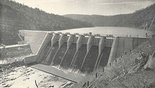
Ocoee Dam No. 3 is a hydroelectric dam on the Ocoee River in Polk County, in the U.S. state of Tennessee. It is one of four dams on the Toccoa/Ocoee River owned and operated by the Tennessee Valley Authority, which built the dam in the early 1940s to meet emergency demands for electricity during World War II. The dam impounds the 360-acre (150 ha) Ocoee No. 3 Reservoir, which stretches 11 miles (18 km) upriver to the Tennessee-Georgia state line. Ocoee No. 3's powerhouse is actually located several miles downstream from the dam, and is fed by a 2.5-mile (4.0 km) conduit that carries water to it from the reservoir.

The Ocoee Whitewater Center, near Ducktown, Tennessee, United States, was the canoe slalom venue for the 1996 Summer Olympics in Atlanta, and is the only in-river course to be used for Olympic slalom competition. A 1,640 foot stretch of the Upper Ocoee River was narrowed by two-thirds to create the drops and eddies needed for a slalom course. Today, the course is watered only on summer weekends, 34 days a year, for use by guided rafts and private boaters. When the river has water, 24 commercial rafting companies take more than 750 raft passengers through the course each day.

Ocoee is an unincorporated community in Polk County, Tennessee, United States and named after the Cherokee settlement located in the area. It has a post office with the ZIP code 37361.

State Route 33 is a primary and secondary route in East Tennessee. It runs 176 miles, from the Georgia state line in Polk County, northeast to the Virginia state line north of Kyles Ford in Hancock County. South of Maryville, SR 33 is a "hidden" route which shares a concurrency with US 411.

State Route 30 is an east-west state highway in the central and eastern portions of the U.S. state of Tennessee. It runs generally west to east, connecting McMinnville in Warren County with Parksville along the Ocoee River in Polk County. It crosses several major geographic features in Tennessee, including the Cumberland Plateau, the Sequatchie Valley, the Tennessee River, and parts of the Cherokee National Forest.