
Table Rock Lake is an artificial lake or reservoir in the Ozarks of southwestern Missouri and northwestern Arkansas in the United States. Designed, built and operated by the U.S. Army Corps of Engineers, the lake is impounded by Table Rock Dam, which was constructed from 1954 to 1958 on the White River.

The Midstate Trail is a scenic footpath which runs 92 miles (148 km) through Worcester County, Massachusetts, from the Rhode Island border to the New Hampshire border, approximately 45 miles (72 km) west of Boston. The trail is considered highly accessible, scenic, and remarkably rural despite its proximity to urban Boston. The trail includes the summits of Mount Wachusett and Mount Watatic, as well as many interesting geologic, historic, and natural features.
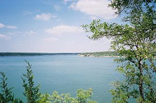
Lake Georgetown is a reservoir on the north fork of the San Gabriel River in central Texas in the United States. Lake Georgetown is a U.S. Army Corps of Engineers reservoir formed on the San Gabriel by the North San Gabriel Dam, which is located about three miles west of Georgetown, Texas. The dam, lake, and all adjacent property are managed by the Fort Worth District of the U.S. Army Corps of Engineers. The dam was officially completed on October 5, 1979, and serves to provide flood control for the community of Georgetown. Lake Georgetown is also a source of drinking water for Georgetown and the nearby city of Round Rock. The lake is also a popular recreational destination.

Perry Lake is a US Army Corps of Engineers operated reservoir in northeast Kansas. Its primary purposes are flood control, water reserve for nearby areas and regional recreation. The lake is approximately 11,150 acres (45 km²) in size, with over 160 miles (260 km) of shoreline. Perry Lake's full multi-purpose pool elevation is 891.5 feet (271.7 m) above sea level. Perry Lake is located about 40 miles (64 km) west of Kansas City, just northwest of Lawrence, Kansas. Its close proximity to Kansas City, Lawrence, and the state capitol, Topeka, make it a very popular destination, with the nickname "Paradise on the Plains".

Lake Dennison Recreation Area is a 121-acre (49 ha) Massachusetts state park located in the town of Winchendon. It comprises a small portion of the 4,221 acres (1,708 ha) of the U.S. Army Corps of Engineers' Birch Hill Flood Control Project that are managed by the Department of Conservation and Recreation and that also include Otter River State Forest.

Lost Creek Lake is a reservoir located on the Rogue River in Jackson County, Oregon, United States. The lake is impounded by William L. Jess Dam which was constructed by the U.S. Army Corps of Engineers in 1977 for flood control and fisheries enhancement. The lake and dam were the first completed elements of the multi-purpose Rogue River Basin Project, consisting of Lost Creek Lake, Applegate Lake and the Elk Creek project. The lake is located approximately 27 miles (43 km) northeast of Medford.

Mansfield Hollow Lake is a reservoir resting on the border of Windham County and Tolland County, Connecticut. The reservoir provides drinking water for Willimantic and helps control flooding in the 159-square-mile Thames River watershed. It was created by the Mansfield Hollow Dam and is entirely contained within Mansfield Hollow State Park and the Mansfield Hollow Wildlife Area. Designed and constructed by the United States Army Corps of Engineers, the dam substantially reduces flooding along the Quinebaug, Shetucket, and Thames rivers. Construction of the project began in 1949 with completion in 1952 at a cost of US$6.5 million. The Mansfield Hollow reservoir is located within the Shetucket River Watershed and is part of the Thames River Basin. Access to the site is available from US Route 6 and State Route 195. The damsite, covering an area of 25 acres (10 ha), was listed on the National Register of Historic Places in 2003.

The Conant Brook Dam is located on Conant Brook in Monson, Massachusetts, about 7.4 miles (11.9 km) upstream from the confluence of Conant Brook and the Quaboag River. It is approximately 15 miles (24 km) east of Springfield, Massachusetts.

Royalston Falls is a 50 foot (15 m) waterfall and granite gorge located in Royalston, Massachusetts along Falls Brook, a tributary of the Tully River which in turn is a tributary of the Millers River. The falls are part of a 217-acre (88 ha) open space preserve acquired in 1951 by the land conservation non-profit organization The Trustees of Reservations. The 22-mile (35 km) Tully Trail and the 110-mile (180 km) Metacomet-Monadnock Trail, a National Recreation Trail, pass through the property.

Buffumville Lake is a 200-acre (0.81 km2), 5.2-billion-US-gallon (20,000,000 m3) capacity United States Army Corps of Engineers flood control lake project located in Charlton, Massachusetts. The lake and surrounding grounds are open to the public for hiking, boating, fishing, and hunting. A 27-hole frisbee golf course is located next to the lake. Buffumville Lake is managed as a unit with the nearby Hodges Village Dam flood control project.

West Hill Dam Reserve is a United States Army Corps of Engineers flood control project with a recreational park and wildlife management area located at Uxbridge, Massachusetts. The West Hill Dam Project was completed in 1960. It is located on the West River, one of the branches of the Blackstone River which flows from Worcester, MA to Providence, RI. The West River originates in Grafton, Massachusetts, at Cider Mill Pond and Silver Lake, near Upton, Massachusetts, and the Upton State Forest. The dam is unusual in that it isn't filled unless there is a flood. West Hill Dam was built after devastating floods during the 1950s; it is intended to protect the Blackstone Valley from future destructive flooding. The cities and towns downriver from Uxbridge, including Millville, Blackstone, Woonsocket, North Smithfield, Cumberland, Lincoln, Central Falls, Pawtucket and Providence, Rhode Island, suffered extensive flooding from the Blackstone during Hurricane Diane in 1955. Hurricane Donna tested this new dam in 1960 as the eyewall passed over. The West Hill Dam is located in the Blackstone River Valley National Heritage Corridor near the Blackstone River and Canal Heritage State Park. Park rangers provide visitor assistance and offer scheduled interpretative programs. Fishing, hunting, and wildlife viewing opportunities are available year-round. The park has a recreation area, 34 picnic sites, one playground, a swimming area and five miles of hiking trails. However, access to the park from West Hill Road is currently blocked as of 2021 because of landowner disagreements. West Hill Dam is also the field office for the Charles River Natural Valley Storage Area. It consists of scattered wetlands in the upper and middle Charles River watershed, between the towns of Bellingham and Needham. The wetlands provide flood storage area, fisheries, wildlife management, and recreation. The Charles River is the well-known watercourse that flows into Boston Harbor.
The West River, in the US state of Massachusetts, is a 13.4-mile-long (21.6 km) tributary of the Blackstone River.

Doane's Falls is a series of five waterfalls located in Royalston, Massachusetts along an 0.2-mile (0.32 km) section of Lawrence Brook, a tributary of the Millers River that originates from Laurel Lake in Fitzwilliam. The falls are part of a 46-acre (19 ha) open space preserve acquired in 1959 by the land conservation non-profit organization The Trustees of Reservations. The 22-mile (35 km) Tully Trail passes through the property.
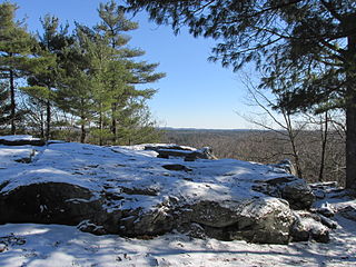
Jacobs Hill is a 173-acre (70 ha) open space preserve in Royalston, Massachusetts acquired in 1975 by the land conservation non-profit organization The Trustees of Reservations. The preserve includes scenic vistas, ledges, woodlands, a northern bog, and Spirit Falls, a 30 foot (9.1 m) waterfall. The 22-mile (35 km) Tully Trail passes through the property. Views from the ledges include the Berkshires as well as nearby Long Pond and the Tully River Valley, Tully Mountain, and Mount Grace.

Quinebaug Woods is a 36-acre (15 ha) open space preserve located in Holland, Massachusetts. The property, acquired in 2001 by the land conservation non-profit organization The Trustees of Reservations, is named for the Quinebaug River, which runs through the reservation.

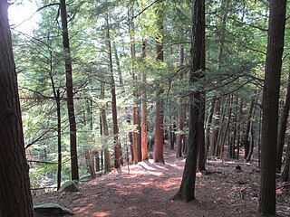
Tully Lake, of Royalston, Massachusetts, is a 1,262-acre (511 ha) reservoir and flood control project constructed by the United States Army Corps of Engineers (USACE) in 1949 for 1.6 million dollars. The project prevents flooding of the greater Connecticut River and Millers River valleys and provides a variety of recreational opportunities, including a campground operated by The Trustees of Reservations. Tully Lake is an important link in the 22-mile (35 km) Tully Trail.
Noon Hill is a 204-acre (83 ha) open space preserve located in Medfield, Massachusetts and centered on 370-foot (110 m) Noon Hill, a prominent summit and scenic vista. It is managed by the land conservation non-profit organization The Trustees of Reservations and offers 4.5 miles (7.2 km) of trails available for hiking, horseback riding, mountain biking, and cross country skiing. Oak-hickory forest, wetlands, vernal pools, steep ravines, boulders, and rocky ledges characterize the preserve. Noon Hill is a link in the 200-mile (320 km) Bay Circuit Trail. Holt Pond, a constructed mill pond, is located on the property.

John Redmond Reservoir is a reservoir on the Neosho River in eastern Kansas. Built and managed by the U.S. Army Corps of Engineers, it is used for flood control, recreation, water supply, and wildlife management. It borders the Flint Hills National Wildlife Refuge to the northwest.

The Four Mile Run Trail is a 7-mile long, paved shared use path in Arlington County, Virginia. It runs along Four Mile Run from Benjamin Banneker Park in Falls Church to the Mount Vernon Trail near Ronald Reagan Washington National Airport, where Four Mile Run empties into the Potomac River. The trail runs roughly parallel to parts of the Washington & Old Dominion Railroad Trail as it follows Four Mile Run, sometimes on the other side of the stream.
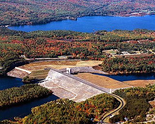
The Franklin Falls Dam is located on the Pemigewasset River in the city of Franklin, New Hampshire, in the United States. The dam was constructed between 1939 and 1943 by the Army Corps of Engineers and extends for 0.75 miles (1.21 km) across the river. During its construction, the neighboring residents of the town of Hill were forced to relocate to higher ground due to rising water levels created by the dam. The reservoir formed by the dam has a permanent pool covering 440 acres (180 ha), and the total flood storage capacity is 2,800 acres (1,100 ha). The total area of the project, including surrounding managed lands, is 3,683 acres (1,490 ha). The stretch of the Pemigewasset River potentially impounded by the dam extends 12.5 miles (20 km) north to Ayers Island Dam in the town of Bristol, and the watershed flowing to the dam extends north all the way into the White Mountains.
