Buckinghamshire is a ceremonial county in South East England and one of the home counties. It is bordered by Northamptonshire to the north, Bedfordshire to the north-east, Hertfordshire to the east, Greater London to the south-east, Berkshire to the south, and Oxfordshire to the west. The largest settlement is the city of Milton Keynes, and the county town is Aylesbury.

Milton Keynes is a city in Buckinghamshire, England, about 50 miles (80 km) north-west of London. At the 2021 Census, the population of its urban area was 264,349. The River Great Ouse forms the northern boundary of the urban area; a tributary, the River Ouzel, meanders through its linear parks and balancing lakes. Approximately 25% of the urban area is parkland or woodland and includes two Sites of Special Scientific Interest (SSSIs).
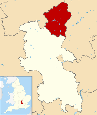
The City of Milton Keynes is a unitary authority area with both borough and city status, in Buckinghamshire. It is the northernmost district of the South East England Region. The borough abuts Bedfordshire, Northamptonshire and the remainder of Buckinghamshire.
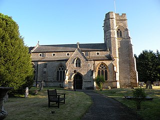
Emberton is a village and civil parish in the unitary authority area of the City of Milton Keynes, in Buckinghamshire, England. The village is near the borders with Northamptonshire and Bedfordshire, just to the south of Olney, 4 miles (6.4 km) north of Newport Pagnell, and 7 miles (11 km) north-east of Central Milton Keynes.

Great Linford is a historic village, district and wider civil parish in the north of Milton Keynes, England, between Wolverton and Newport Pagnell, and roughly 2 miles (3.2 km) north of Central Milton Keynes.
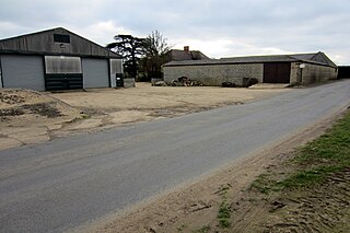
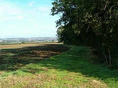
Little Linford is a village and former civil parish, now in the parish of Haversham-cum-Little Linford, in the City of Milton Keynes, Buckinghamshire, England. Located near the M1 motorway, the village is about 2 miles (3.2 km) north-west of Newport Pagnell and 3.5 miles (5.6 km) north of Central Milton Keynes. The village is separated from its neighbour and namesake Great Linford by the floodplain of the River Great Ouse. In 1931 the parish had a population of 45. On 1 April 1934 the parish was abolished and merged with Haversham to form "Haversham cum Little Linford".
Shenley Brook End is a village, district and wider civil parish in Milton Keynes, Buckinghamshire, England, located about 2 miles (3.2 km) north-west of Bletchley, and 2.5 miles (4.0 km) south-west of Central Milton Keynes. Together with its neighbouring districts of Shenley Church End, Shenley Wood and Shenley Lodge, the districts are collectively known as "The Shenleys".

Walton was historically a hamlet and now a district and civil parish in Milton Keynes, Buckinghamshire, England. For local government purposes, it is part of the Danesborough and Walton electoral ward. At the 2021 census, the parish had a population of 12,100.

Milton Keynes Dons Football Club, usually abbreviated to MK Dons, is a professional association football club based in Milton Keynes, Buckinghamshire, England. The team competes in EFL League Two, the fourth level of the English football league system. The club was founded in 2004, following Wimbledon F.C.'s controversial relocation to Milton Keynes from south London, when it adopted its present name, badge and home colours.

Milton Keynes Central railway station serves Milton Keynes and surrounding parts of Bedfordshire, Buckinghamshire and Northamptonshire (England). The station is located on the West Coast Main Line about 50 miles (80 km) northwest of London. The station is served by Avanti West Coast intercity services, and by West Midlands Trains regional services.

Stadium MK is a football stadium in the Denbigh district of Bletchley in Milton Keynes, Buckinghamshire, England. Designed by Populous and opened in 2007, it is the home ground of EFL League Two side Milton Keynes Dons and FA Women's National League South side Milton Keynes Dons Women. In 2022, the stadium hosted several matches during the UEFA Women's Euro 2022.

Milton Keynes University Hospital is a district general hospital serving the City of Milton Keynes and the surrounding area of Buckinghamshire, Northamptonshire, Bedfordshire and Oxfordshire. It is located in the Eaglestone neighbourhood, and opened in 1984. It is managed by Milton Keynes University Hospital NHS Foundation Trust. The hospital has an association with the University of Buckingham Medical School.

This history of Milton Keynes details its development from the earliest human settlements, through the plans for a 'new city' for 250,000 people in northern Southeast England, its subsequent urban design and development, to the present day. Milton Keynes, founded in 1967, is the largest settlement and only city in Buckinghamshire. At the 2021 census, the population of its urban area was estimated to have exceeded 256,000.

Milton Keynes City Council is the local authority for the City of Milton Keynes, a local government district in Buckinghamshire, England. The council was established in 1974 as Milton Keynes Borough Council. Since 1997 it has been a unitary authority, being a district council which also performs the functions of a county council; it is independent of Buckinghamshire Council, the unitary authority which administers the rest of the county.

The Milton Keynes grid road system is a network of predominantly national speed limit, fully landscaped routes that form the top layer of the street hierarchy for both private and public transport in Milton Keynes, Buckinghamshire. The system is unique in the United Kingdom for its innovative use of street hierarchy principles: the grid roads run in between districts rather than through them. This arrangement permits higher speed limits due to the absence of buildings close to the roads – although more recently some have been limited in part to 40 mph (64 km/h). The grid road system also serves an important purpose of discouraging through-traffic from travelling through neighbourhoods and thus reduces traffic noise and pollution in pedestrian areas. Motor traffic is segregated from pedestrian and leisure cycling traffic, which uses the alternative Milton Keynes redway system. Almost all grid junctions are roundabouts, and the absence of traffic lights enables free and efficient movement of traffic.

The Milton Keynes urban area or Milton Keynes Built-up Area is a designation established by the United Kingdom's Office for National Statistics. Milton Keynes has no statutory boundary: the 1967 designated area only determined the area assigned to the Milton Keynes Development Corporation for development. The wider urban area outside that designation includes Newport Pagnell and Woburn Sands as well as Aspley Guise (Bedfordshire) and part of Stoke Hammond civil parish.
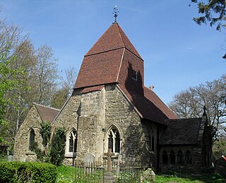
Church in the Wood, officially known as St Leonard's Church and originally as St Rumbold's Church, is an Anglican church in the Hollington area of the town and borough of Hastings, one of six local government districts in the English county of East Sussex. Although Hollington is now a large suburb, consisting mostly of postwar residential development, the church has stood in isolation in the middle of an ancient wood since it was founded in the 13th century—almost certainly as the successor to an 11th-century chapel. Restoration work in the Victorian era has given the Early English Gothic-style building its present appearance, but some medieval work remains. Legends and miraculous events have been associated with the church, and its secluded situation has been praised by writers including Charles Lamb. The church is a Grade II Listed building.

The Parks Trust is a British registered charity formed in 1992 by Milton Keynes Development Corporation to take over the public parks in Milton Keynes, Buckinghamshire.

Howe Park Wood is a 21.4-hectare (53-acre) Site of Special Scientific Interest in Tattenhoe, a district of Milton Keynes in Buckinghamshire. It is owned by Milton Keynes City Council and managed by Milton Keynes Parks Trust.