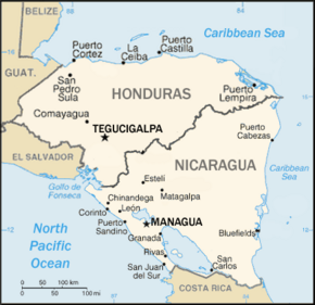
Central America is a subregion of North America. Its political boundaries are defined as bordering Mexico to the north, Colombia to the south, the Caribbean Sea to the east, and the Pacific Ocean to the west. Central America is usually defined as consisting of seven countries: Belize, Costa Rica, El Salvador, Guatemala, Honduras, Nicaragua, and Panama. Within Central America is the Mesoamerican biodiversity hotspot, which extends from northern Guatemala to central Panama. Due to the presence of several active geologic faults and the Central America Volcanic Arc, there is a high amount of seismic activity in the region, such as volcanic eruptions and earthquakes, which has resulted in death, injury, and property damage.

Central America is commonly said to include Guatemala, Belize, El Salvador, Honduras, Nicaragua, Costa Rica, and Panama. This definition matches modern political borders. Central America begins geographically in Mexico, at the Isthmus of Tehuantepec, Mexico's narrowest point, and the former country of Yucatán (1841–1848) was part of Central America. At the other end, before its independence in 1903 Panama was part of South America, as it was a Department of Colombia. At times Belize, a British colony until 1981, where English instead of Spanish is spoken, and where the population is primarily of African origin, has been considered not part of (Spanish-speaking) Central America.

The Adams–Onís Treaty of 1819, also known as the Transcontinental Treaty, the Spanish Cession, the Florida Purchase Treaty, or the Florida Treaty, was a treaty between the United States and Spain in 1819 that ceded Florida to the U.S. and defined the boundary between the U.S. and Mexico. It settled a standing border dispute between the two countries and was considered a triumph of American diplomacy. It came during the successful Spanish American wars of independence against Spain.

Choluteca is one of the 18 departments (departamentos) into which Honduras is divided. The departmental capital is the city of Choluteca. The Choluteca River runs through the department.

Serranilla Bank is a partially submerged reef, with small uninhabited islets, in the western Caribbean Sea. It is situated about 350 kilometres (220 mi) northeast of Punta Gorda, Nicaragua, and roughly 280 kilometres (170 mi) southwest of Jamaica. The closest neighbouring land feature is Bajo Nuevo Bank, located 110 kilometres (68 mi) to the east.

Bajo Nuevo Bank, also known as the Petrel Islands, is a small, uninhabited reef with some small grass-covered islets, located in the western Caribbean Sea at 15°53′N78°38′W, with a lighthouse on Low Cay at 15°51′N78°38′W. The closest neighbouring land feature is Serranilla Bank, located 110 kilometres to the west.
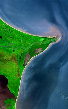
The Gulf of Fonseca, a part of the Pacific Ocean, is a gulf in Central America, bordering El Salvador, Honduras, and Nicaragua.

During Spain's New World Empire, its mainland coastal possessions surrounding the Caribbean Sea and the Gulf of Mexico were referred to collectively as the Spanish Main. The southern portion of these coastal possessions were known as the Province of Tierra Firme, or the "Mainland Province". The Province of Tierra Firme, or simply Tierra Firme, was also called Costa Firme.
Territorial disputes of Nicaragua include the territorial dispute with Colombia over the Archipelago of San Andrés, Providencia and Santa Catalina and Quita Sueño Bank. Nicaragua also has a maritime boundary dispute with Honduras in the Caribbean Sea and a boundary dispute over the Rio San Juan with Costa Rica.
Honduras has been inhabited by a number of indigenous peoples, the most powerful of which, until the ninth century CE, were the Maya. The western-central part of Honduras was inhabited by the Lenca while other indigenous peoples settled in the northeast and coastal regions. These peoples had their conflicts but maintained commercial relationships with each other and with other populations as distant as Panama and Mexico.

El Salvador became independent from Spain in 1821. It has produced its own stamps since 1867.

The Association football competition at the 2010 Central American and Caribbean Games were set to start 21 July, although qualification took take place beforehand. All participants had to be born on or after 1 January 1989. On 13 July 2010, the organizing committee for the games (Comaz) announced that the event would not be held because CONCACAF had threatened to sanction countries that participated.

The Spanish conquest of Honduras was a 16th-century conflict during the Spanish colonization of the Americas in which the territory that now comprises the Republic of Honduras, one of the seven states of Central America, was incorporated into the Spanish Empire. In 1502, the territory was claimed for the king of Spain by Christopher Columbus on his fourth and final trip to the New World. The territory that now comprises Honduras was inhabited by a mix of indigenous peoples straddling a transitional cultural zone between Mesoamerica to the northwest, and the Intermediate Area to the southeast. Indigenous groups included Maya, Lenca, Pech, Miskitu, Mayangna (Sumu), Jicaque, Pipil and Chorotega. Two indigenous leaders are particularly notable for their resistance against the Spanish; the Maya leader Sicumba, and the Lenca ruler referred to as Lempira.

The Spanish conquest of El Salvador was the campaign undertaken by the Spanish conquistadores against the Late Postclassic Mesoamerican polities in the territory that is now incorporated into the modern Central American country of El Salvador. El Salvador is the smallest country in Central America, and is dominated by two mountain ranges running east–west. Its climate is tropical, and the year is divided into wet and dry seasons. Before the conquest the country formed a part of the Mesoamerican cultural region, and was inhabited by a number of indigenous peoples, including the Pipil, the Lenca, the Xinca, and Maya. Native weaponry consisted of spears, bows and arrows, and wooden swords with inset stone blades; they wore padded cotton armour.
The Spanish conquest of Nicaragua was the campaign undertaken by the Spanish conquistadores against the natives of the territory now incorporated into the modern Central American republic of Nicaragua during the colonisation of the Americas. Before European contact in the early 16th century, Nicaragua was inhabited by a number of indigenous peoples. In the west, these included Mesoamerican groups such as the Chorotega, the Nicarao, and the Subtiaba. Other groups included the Matagalpa and the Tacacho.