
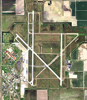
Ellington Airport is a public and military use airport in Harris County, Texas, United States. It is owned by the City of Houston and located 15 nautical miles southeast of downtown Houston. Formerly known as Ellington Field, then Ellington Air Force Base, then again as Ellington Field it is included in the National Plan of Integrated Airport Systems for 2011–2015, which categorized it as a general aviation reliever airport. The airport does not have scheduled commercial passenger service. On October 17, 2018, the City of Houston approved Phase 1 of the Houston Spaceport project on the Ellington Airport site.
Valley International Airport (VIA) is owned by the City of Harlingen, in Cameron County, Texas. It is operated by a nine-member airport board appointed by the mayor. HRL is centrally located in the Rio Grande Valley and is referred to as the "Gateway to South Padre Island" with travel amenities and door to door transportation to South Padre Island. With over 2,400 acres HRL is the largest airport in the RGV with room for future expansion. HRL has the longest runways in the area with modern aircraft approach systems that minimize chances of delays during bad weather.

Tyler Pounds Regional Airport is three miles west of Tyler, in Smith County, Texas.
Robert Gray Army Airfield is a military joint-use airport that operates alongside Killeen–Fort Hood Regional Airport. The airport is based inside the south end of the Fort Hood Military Reservation, six nautical miles southwest of the central business district of Killeen, Texas, in unincorporated Bell County.

Arlington Municipal Airport is a public use airport located four nautical miles (7 km) south of the central business district of Arlington, a city in Tarrant County, Texas, United States. The airport is at the intersection of Interstate 20 and South Collins Road. This airport is publicly owned by the City of Arlington and serves as a reliever airport for Dallas/Fort Worth International Airport and Dallas Love Field.

Fort Morgan Municipal Airport is six miles north of Fort Morgan, in Morgan County, Colorado. The airport is in the city limits in a detached section of the city. The National Plan of Integrated Airport Systems for 2011–2015 categorized it as a general aviation facility.
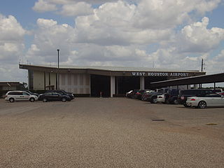
West Houston Airport is a privately owned, public use airport in Harris County, Texas, United States. It is located 13 nautical miles west of Downtown Houston, in an unincorporated area of the county, immediately west of the Houston city limits in the Greater Katy area. It was established in 1962 and was formerly called Lakeside Airport up until the early 1980s, which was in reference to its location near the edge of Addicks reservoir.

Houston Southwest Airport or Houston-Southwest Airport is a public-use airport located in Arcola, a city in Fort Bend County, Texas, United States, 15 miles (24 km) southwest of the central business district of Houston. It is privately owned by James Griffith, Jr.
Liberty Municipal Airport is a public use airport in Liberty County, Texas, United States. It is owned by the City of Liberty and is located six nautical miles (11 km) northeast of its central business district.
Fish River Seaplane Base is a public-use seaplane base on Fish River in Baldwin County, Alabama, United States. The facility is located nine nautical miles southeast of the central business district of Fairhope, Alabama. It has one seaplane landing area designated 16W/34W which measures 4,395 by 200 feet.

Cardiff Brothers Airport was an airport located in unincorporated Fort Bend County, Texas, United States, east of the city of Fulshear and south of the city of Katy.

Ridge Landing Airpark, also known as Ridge Landing Airport, is a private use airpark located four nautical miles west of the central business district of Frostproof, a city in Polk County, Florida, United States. Ridge Landing is an airpark community located between Lake Wales and Sebring, Ridge Landing offers pilots airport homes with private airstrips. Ridge Landing is centrally located between Orlando and Tampa and equidistant to Miami and Jacksonville. It is privately owned by John Fazzini.
Elizabeth Field is a public use airport located on Fishers Island, in Suffolk County, New York, United States. It is owned by the Town of Southold. According to the FAA's National Plan of Integrated Airport Systems for 2009-2013, Elizabeth Field is classified as a general aviation airport.
Vashon Municipal Airport is a municipal airport on Vashon Island in King County, Washington, United States. The airport is unique in being one of the few public airports in Washington State with only a grass runway. Other state-owned public grass-only runway airports exist in Washington, but these are actually more accurately landing strips, as they are not equipped with hangars.
Hubbard Landing Seaplane Base is a privately owned public-use seaplane base in Baldwin County, Alabama, United States. It is located five nautical miles southeast of the central business district of Stockton, Alabama.
Cleburne Regional Airport is a city-owned, public-use airport located two nautical miles (4 km) northwest of the central business district of Cleburne, a city in Johnson County, Texas, United States. Formerly known as Cleburne Municipal Airport, it is included in the National Plan of Integrated Airport Systems for 2011–2015, which categorized it as a general aviation facility.
McCampbell–Porter Airport is a county-owned, public-use airport in San Patricio County, Texas, United States. It is located two nautical miles (4 km) north of the central business district of Ingleside, Texas. Formerly known as T. P. McCampbell Airport, it is included in the National Plan of Integrated Airport Systems for 2011–2015, which categorized it as a general aviation facility.
Rockin' M Airport is a privately owned, public use airport located three nautical miles (6 km) northeast of the central business district of Quinlan, a city in Hunt County, Texas, United States.
Horseshoe Bend Airport is a privately owned public airport in Weatherford, Parker County, Texas, United States, located approximately 12 nautical miles (22 km) southwest of the central business district. The airport has no IATA or ICAO designation.
Bishop's Landing Airport is a privately owned public airport in Celina, Collin County, Texas, United States, located approximately 5 nautical miles (9.3 km) northeast of the central business district. The airport has no IATA or ICAO designation.


