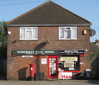
Atherton is a town in the Metropolitan Borough of Wigan, in Greater Manchester, England and historically was a part of Lancashire. The town, including Hindsford, Howe Bridge and Hag Fold, is 5 miles (8.0 km) east of Wigan, 2 miles (3.2 km) north of Leigh, and 10.7 miles (17.2 km) northwest of Manchester. From the 17th century, for about 300 years, Atherton was known as Chowbent, which was frequently shortened to Bent, the town's old nickname.

A pit village, colliery village or mining village is a settlement built by colliery owners to house their workers. The villages were built on the coalfields of Britain during the Industrial Revolution where new coal mines in isolated or unpopulated areas needed accommodation for the incoming workers.

The Pretoria Pit disaster was a mining accident on 21 December 1910, when an underground explosion occurred at the Hulton Colliery Bank Pit No. 3, known as the Pretoria Pit, in Over Hulton, Westhoughton, then in the historic county of Lancashire, in North West England. A total of 344 men & boys lost their lives.
Agecroft Colliery was a coal mine on the Manchester Coalfield that opened in 1844 in the Agecroft district of Pendlebury, Lancashire, England. It exploited the coal seams of the Middle Coal Measures of the Lancashire Coalfield. The colliery had two spells of use; the first between 1844 and 1932, when the most accessible coal seams were exploited, and a second lease of life after extensive development in the late 1950s to access the deepest seams.
The Astley and Tyldesley Collieries Company formed in 1900 owned coal mines on the Lancashire Coalfield south of the railway in Astley and Tyldesley, then in the historic county of Lancashire, England. The company became part of Manchester Collieries in 1929 and some of its collieries were nationalised in 1947.
Bedford Colliery, also known as Wood End Pit, was a coal mine on the Manchester Coalfield in Bedford, Leigh, Lancashire, England. The colliery was owned by John Speakman, who started sinking two shafts on land at Wood End Farm in the northeast part of Bedford, south of the London and North Western Railway's Tyldesley Loopline in about 1874. Speakman's father owned Priestners, Bankfield, and Broadoak collieries in Westleigh. Bedford Colliery remained in the possession of the Speakman family until it was amalgamated with Manchester Collieries in 1929.

The Manchester Coalfield is part of the South Lancashire Coalfield, the coal seams of which were laid down in the Carboniferous Period. Some easily accessible seams were worked on a small scale from the Middle Ages, and extensively from the beginning of the Industrial Revolution in the early 19th century until the last quarter of the 20th century. The Coal Measures lie above a bed of Millstone Grit and are interspersed with sandstones, mudstones, shales, and fireclays. The Lower Coal Measures occupy the high ground of the West Pennine Moors above Bolton and are not worked in the Manchester Coalfield. The most productive of the coal measures are the lower two thirds of the Middle Coal Measures where coal is mined from seams between the Worsley Four Foot and Arley mines. The deepest and most productive collieries were to the south of the coalfield. The coalfield is affected by the northwest to southeast aligned Pendleton Fault along the Irwell Valley and the Rossendale Anticline. The Coal Measures generally dip towards the south and west. Numerous other smaller faults affect the coalfield. The Upper Coal Measures are not worked in the Manchester Coalfield.
Manchester Collieries was a coal mining company with headquarters in Walkden formed from a group of independent companies operating on the Manchester Coalfield in 1929. The Mining Industry Act of 1926 attempted to stem the post-war decline in coal mining and encourage independent companies to merge in order to modernise and better survive the economic conditions of the day. Robert Burrows of the Atherton company Fletcher Burrows proposed a merger of several independent companies operating to the west of Manchester. The merger was agreed and took place in March 1929.
Fletcher, Burrows and Company was a coal mining company that owned collieries and cotton mills in Atherton, Greater Manchester, England. Gibfield, Howe Bridge and Chanters collieries exploited the coal mines (seams) of the middle coal measures in the Manchester Coalfield. The Fletchers built company housing at Hindsford and a model village at Howe Bridge which included pit head baths and a social club for its workers. The company became part of Manchester Collieries in 1929. The collieries were nationalised in 1947 becoming part of the National Coal Board.

Astley Green Colliery was a coal mine in Astley, Greater Manchester, then in the historic county of Lancashire, England. It was the last colliery to be sunk in Astley. Sinking commenced in 1908 by the Pilkington Colliery Company, a subsidiary of the Clifton and Kersley Coal Company, at the southern edge of the Manchester Coalfield, working the Middle Coal Measures where they dipped under the Permian age rocks under Chat Moss. The colliery was north of the Bridgewater Canal. In 1929 it became part of Manchester Collieries, and in 1947 was nationalised and integrated into the National Coal Board. It closed in 1970, and is now Astley Green Colliery Museum.

Gibfield Colliery was a coal mine owned by Fletcher, Burrows and Company in Atherton, then in the historic county of Lancashire, England.

Howe Bridge Colliery was a coal mine which was part of the Fletcher, Burrows and Company's collieries at Howe Bridge in Atherton, Greater Manchester, then in the historic county of Lancashire, England.
Chanters Colliery was a coal mine which was part of the Fletcher, Burrows and Company's collieries at Hindsford in Atherton, Greater Manchester, then in the historic county of Lancashire, England.

The Maypole Colliery disaster was a mining accident on 18 August 1908, when an underground explosion occurred at the Maypole Colliery, in Abram, near Wigan, then in the historic county of Lancashire, in North West England. The final death toll was 76.

The Burnley Coalfield is the most northerly portion of the Lancashire Coalfield. Surrounding Burnley, Nelson, Blackburn and Accrington, it is separated from the larger southern part by an area of Millstone Grit that forms the Rossendale anticline. Occupying a syncline, it stretches from Blackburn past Colne to the Yorkshire border where its eastern flank is the Pennine anticline.