The Northwest Passage (NWP) is the sea lane between the Atlantic and Pacific oceans through the Arctic Ocean, along the northern coast of North America via waterways through the Arctic Archipelago of Canada. The eastern route along the Arctic coasts of Norway and Siberia is accordingly called the Northeast Passage (NEP). The various islands of the archipelago are separated from one another and from Mainland Canada by a series of Arctic waterways collectively known as the Northwest Passages, Northwestern Passages or the Canadian Internal Waters.
Robert Bylot was an English explorer who made four voyages to the Arctic. He was uneducated and from a working-class background, but was able to rise to rank of master in the English Royal Navy.

Hudson Strait in Nunavut links the Atlantic Ocean and the Labrador Sea to Hudson Bay in Canada. This strait lies between Baffin Island and Nunavik, with its eastern entrance marked by Cape Chidley in Newfoundland and Labrador and Nunavut and Resolution Island, off Baffin Island. The strait is about 750 km (470 mi) long with an average width of 125 km (78 mi), varying from 70 km (43 mi) at the eastern entrance to 240 km (150 mi) at Deception Bay.

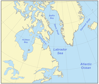
Baffin Bay, located between Baffin Island and the west coast of Greenland, is defined by the International Hydrographic Organization as a marginal sea of the Arctic Ocean. It is sometimes considered a sea of the North Atlantic Ocean. It is connected to the Atlantic via Davis Strait and the Labrador Sea. The narrower Nares Strait connects Baffin Bay with the Arctic Ocean. The bay is not navigable most of the year because of the ice cover and high density of floating ice and icebergs in the open areas. However, a polynya of about 80,000 km2 (31,000 sq mi), known as the North Water, opens in summer on the north near Smith Sound. Most of the aquatic life of the bay is concentrated near that region.

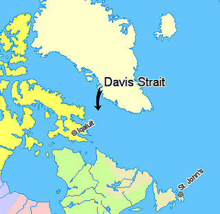
The Davis Strait is a southern arm of the Arctic Ocean that lies north of the Labrador Sea. It lies between mid-western Greenland and Baffin Island in Nunavut, Canada. To the north is Baffin Bay. The strait was named for the English explorer John Davis (1550–1605), who explored the area while seeking a Northwest Passage. By the 1650s it was used for whale hunting.

The Labrador Sea is an arm of the North Atlantic Ocean between the Labrador Peninsula and Greenland. The sea is flanked by continental shelves to the southwest, northwest, and northeast. It connects to the north with Baffin Bay through the Davis Strait. It is a marginal sea of the Atlantic.

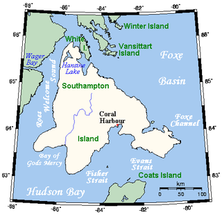
Southampton Island is a large island at the entrance to Hudson Bay at Foxe Basin. One of the larger members of the Arctic Archipelago, Southampton Island is part of the Kivalliq Region in Nunavut, Canada. The area of the island is stated as 41,214 km2 (15,913 sq mi) by Statistics Canada. It is the 34th largest island in the world and Canada's ninth largest island. The only settlement on Southampton Island is Coral Harbour, called Salliq in Inuktitut.

Melville Peninsula is a large peninsula in the Canadian Arctic north of Hudson Bay. To the east is Foxe Basin and to the west the Gulf of Boothia. To the north the Fury and Hecla Strait separates it from Baffin Island. To the south Repulse Bay and Frozen Strait separate it from Southampton Island at the north end of Hudson Bay. On the southwest it is connected to the mainland by the Rae Isthmus, named after the Arctic explorer John Rae.

Foxe Basin is a shallow oceanic basin north of Hudson Bay, in Nunavut, Canada, located between Baffin Island and the Melville Peninsula. For most of the year, it is blocked by sea ice and drift ice made up of multiple ice floes.

Fury and Hecla Strait is a narrow Arctic seawater channel located in the Qikiqtaaluk Region of Nunavut, Canada.

The Arctic realm is one of the planet's twelve marine realms, as designated by the WWF and Nature Conservancy. It includes the coastal regions and continental shelves of the Arctic Ocean and adjacent seas, including the Arctic Archipelago, Hudson Bay, and the Labrador Sea of northern Canada, the seas surrounding Greenland, the northern and eastern coasts of Iceland, and the eastern Bering Sea.

The Arctic Archipelago Marine Ecozone, as defined by the Commission for Environmental Cooperation (CEC), is a marine ecozone in the Canadian Arctic, encompassing Hudson Bay, James Bay, the internal waters and some shores of the islands in the Canadian Arctic Archipelago, and the shores of the territories, northern Ontario and western Quebec. Early exploration of these waters by Europeans were conducted to find a passage to the Orient, now referred to as the Northwest Passage.

The Northwest Atlantic Marine Ecozone, as defined by the Commission for Environmental Cooperation (CEC), is a Canadian marine ecozone forming a transitional region between the cold northern waters of the Arctic Ocean and the more temperate waters in its southern extent.

The Western Indo-Pacific is a biogeographic region of the Earth's seas, comprising the tropical waters of the eastern and central Indian Ocean. It is part of the larger Indo-Pacific, which includes the tropical Indian Ocean, the western and central Pacific Ocean, and the seas connecting the two in the general area of Indonesia. The Western Indo-Pacific may be classified as a marine realm, one of the great biogeographic divisions of the world's ocean basins, or as a subrealm of the Indo-Pacific.

The Parry Channel is a natural waterway through the central Canadian Arctic Archipelago. Its eastern two-thirds lie in the territory of Nunavut, while its western third lies in the Northwest Territories. It runs east to west, connecting Baffin Bay in the east with the Beaufort Sea in the west. Its eastern end is the only practical entrance to the Northwest Passage. Its western end would be a natural exit from the archipelago were it not filled with ice. The channel separates the Queen Elizabeth Islands to the north from the rest of Nunavut.
The Hozier Islands are a Baffin Island offshore island group located in the Arctic Archipelago in the territory of Nunavut's Qikiqtaaluk Region. The uninhabited island group lies in the Labrador Sea, east of Hall Peninsula. The Leybourne Islands are 5 km (3.1 mi) to the north. The largest of the Hozier Islands is about 5 miles (8.0 km) long.

The Canadian Arctic Rift System is a major North American geological structure extending from the Labrador Sea in the southeast through Davis Strait, Baffin Bay and the Arctic Archipelago in the northwest. It consists of a series of interconnected rifts that formed during the Paleozoic, Mesozoic and Cenozoic eras. Extensional stresses along the entire length of the rift system have resulted in a variety of tectonic features, including grabens, half-grabens, basins and faults.


