
The Oregon Trail was a 2,170-mile (3,490 km) east-west, large-wheeled wagon route and emigrant trail in the United States that connected the Missouri River to valleys in Oregon. The eastern part of the Oregon Trail spanned part of what is now the state of Kansas and nearly all of what are now the states of Nebraska and Wyoming. The western half of the trail spanned most of the current states of Idaho and Oregon.
Klamath County is one of the 36 counties in the U.S. state of Oregon. As of the 2010 census, the population was 66,380. The county seat is Klamath Falls. The county was named for the Klamath, the tribe of Native Americans living in the area at the time the first European explorers entered the region. Klamath County comprises the Klamath Falls, OR Micropolitan Statistical Area.

The Modoc are a Native American people who originally lived in the area which is now northeastern California and central Southern Oregon. They are currently divided between Oregon and Oklahoma and are enrolled in either of two federally recognized tribes, the Klamath Tribes in Oregon and the Modoc Tribe of Oklahoma, now known as the Modoc Nation.
Fort Hall was a fort that was built in 1834 as a fur trading post by Nathaniel Jarvis Wyeth. It was located on the Snake River in the eastern Oregon Country, now part of present-day Bannock County in southeastern Idaho, United States. Mr. Wyeth was an inventor and businessman from Boston, Massachusetts, who also founded a post at Fort William, in present-day Portland, Oregon, as part of a plan for a new trading and fisheries company. Unable to compete with the powerful British Hudson's Bay Company, based at Fort Vancouver, in 1837 Wyeth sold both posts to it. Great Britain and the United States both operated in the Oregon Country in these years.

Fort Laramie was a significant 19th-century trading post, diplomatic site, and military installation located at the confluence of the Laramie and the North Platte rivers. They joined in the upper Platte River Valley in the eastern part of the U.S. state of Wyoming. The fort was founded as a private trading post in the 1830s to service the overland fur trade; in 1849, it was purchased by the United States Army. It was located east of the long climb leading to the best and lowest crossing point of the Rocky Mountains at South Pass and became a popular stopping point for migrants on the Oregon Trail. Along with Bent's Fort on the Arkansas River, the trading post and its supporting industries and businesses were the most significant economic hub of commerce in the region.

Fort Kearny was a historic outpost of the United States Army founded in 1848 in the western U.S. during the middle and late 19th century. The fort was named after Col. and later General Stephen Watts Kearny. The outpost was located along the Oregon Trail near Kearney, Nebraska. The town of Kearney took its name from the fort. The "e" was added to Kearny by postmen who consistently misspelled the town name. A portion of the original site is preserved as Fort Kearny State Historical Park by the Nebraska Game and Parks Commission.

The Bozeman Trail was an overland route in the western United States, connecting the gold rush territory of southern Montana to the Oregon Trail in eastern Wyoming. Its most important period was from 1863–68. Despite the fact that "the major part of the route in Wyoming used by all Bozeman Trail travelers in 1864 was pioneered by Allen Hurlbut", it was named after John Bozeman. Many miles of the Bozeman Trail in present Montana followed the tracks of Bridger Trail, opened by Jim Bridger in 1864.
The Snake War (1864–1868) was an irregular war fought by the United States of America against the "Snake Indians," the settlers' term for Northern Paiute, Bannock and Western Shoshone bands who lived along the Snake River. Fighting took place in the states of Oregon, Nevada, and California, and in Idaho Territory. Total casualties from both sides of the conflict numbered 1,762 dead, wounded, or captured.

Meek Cutoff was a horse trail road that branched off the Oregon Trail in northeastern Oregon and was used as an alternate emigrant route to the Willamette Valley in the mid-19th century. The road was named for frontiersman Stephen Meek, who was hired to lead the first wagon train along it in 1845. The journey was a particularly hard one, and many of the pioneers lost their lives.
The Klamath Tribes, formerly the Klamath Indian Tribe of Oregon, are a federally recognized Native American Nation consisting of three Native American tribes who traditionally inhabited Southern Oregon and Northern California in the United States: the Klamath, Modoc, and Yahooskin. The tribal government is based in Chiloquin, Oregon.

The Elliott Cutoff was a covered wagon road that branched off the Oregon Trail at the Malheur River where present-day Vale, Oregon, United States is today. The first portion of the road was originally known as the Meek Cutoff after Stephen Meek, a former trapper who led over 1,000 emigrants into the Harney Basin in 1845. There were considerable difficulties for the 1845 train, and after reaching a hill known as Wagontire, the people left Meek and split into groups. They turned north at the Deschutes River and finally returned to the traditional Oregon Trail near The Dalles.
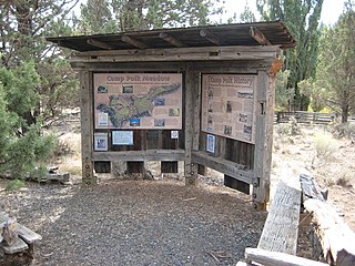
Camp Polk was a former army camp in the U.S. state of Oregon that was established in Deschutes County in 1865. It was a post of the District of Oregon. One of nine camps created during a time of conflict between settlers and Native Americans, it was located three miles northeast of the present-day city of Sisters. The camp was intended to house troops who would protect settlers on the Santiam Wagon Road from Indian attack. Part of Company A, a group of volunteer soldiers from the Willamette Valley under the command of Captain Charles La Follette, were stationed at the post. The camp was named for Polk County, which was the home of most of the soldiers and their captain. No attacks occurred, and the troops received orders before winter in 1865 to leave the camp. A portion of the troops remained at the post until the spring of 1866 when Camp Polk was abandoned.
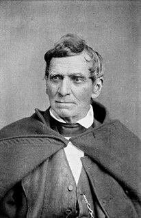
Lindsay Applegate was a pioneer known for his participation in blazing the Applegate Trail, an alternative route of the Oregon Trail. The trail was blazed with his brothers Charles and Jesse in 1846. Charles Applegate was not a member of the party that blazed the Applegate Trail from the Willamette Valley to the Humboldt River. According to an original manuscript written by Lindsay Applegate in 1877, the members of the expedition were: Capt. Levi Scott, John Scott, Henry Boygus, Lindsay Applegate, Jesse Applegate, Benjamin Burch, John Owens, John Jones, Robert Smith, Samuel Goodhue, Moses "Black" Harris, David Goff, Benit Osburn, William Sportsman, and William Parker.
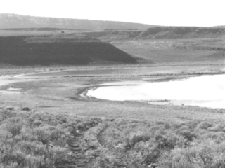
The Stone Bridge is a causeway built by the United States Army in 1867. It crosses the marshy channel that connects Hart Lake and Crump Lake in a remote area of Lake County in eastern Oregon, United States. It was later incorporated into the Oregon Central Military Wagon Road which was completed in 1872. The wagon road eventually became the subject of scandal and litigation ending with a United States Supreme Court decision in 1893. The Stone Bridge and the Oregon Central Military Wagon Road were listed together on the National Register of Historic Places in 1974. Today, the Stone Bridge is located on land claimed by the State of Oregon under riparian rights. The wagon road adjacent to the Stone Bridge is owned by the United States Government and is administered by Bureau of Land Management.

At the outbreak of the American Civil War in 1861, regular U.S. Army troops in the District of Oregon were withdrawn from posts in Oregon and Washington Territory and sent east. Volunteer cavalry and infantry were recruited in California and sent north to Oregon to replace the Federal troops and keep the peace and protect the populace. Oregon also raised the 1st Oregon Cavalry that was activated in 1862 and served until June 1865. During the Civil War, emigrants to the newfound gold fields in Idaho and Oregon continued to clash with the Paiute, Shoshone and Bannock tribes of Oregon, Idaho and Nevada until relations degenerated into the bloody 1864 - 1868 Snake War. The 1st Oregon Volunteer Infantry Regiment was formed in 1864 and its last company was mustered out of service in July 1867. Both units were used to guard travel routes and Indian reservations, escort emigrant wagon trains, and protect settlers from Indian raiders. Several infantry detachments also accompanied survey parties and built roads in central and southern Oregon.
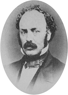
Charles Stewart Drew, also known as C.S. Drew, was a representative in the legislature of the Oregon Territory of the United States and quartermaster general of the territorial militia in the 1850s. During the American Civil War, he was a Union Army officer, serving in the 1st Oregon Cavalry regiment. He eventually reached the rank of lieutenant colonel. In 1864, he led an Army reconnaissance party into southeastern Oregon. The expedition, known as the Owyhee Reconnaissance, traveled through uncharted country from Fort Klamath to Fort Boise and back. Drew was the author of two historically important military reports; one documented Indian attacks on American settlers in the Oregon Territory and the other was his report of the Owyhee Reconnaissance.

Central Oregon Irrigation District is a municipal corporation to provide irrigation water for Central Oregon, U.S. The canals serve agricultural and industrial users in the arid lands between Alfalfa, Bend, Redmond, Terrebonne, and Powell Butte. Among its 4,000 or so individual customer accounts, it also provides municipal water to the city of Redmond, neighboring subdivisions, and parks and schools in Bend. The district manages more than 700 miles (1,100 km) of canals serving about 70.3 square miles (182 km2) of lands within a rough area of 280 square miles (730 km2).
Ady is an unincorporated historic locale in Klamath County, Oregon, United States.

Joseph Sherar was a 19th-century wagon road builder who, with his wife, Jane, owned and operated a Deschutes River toll bridge and a nearby stagecoach station and hotel in Wasco County in the U.S. state of Oregon. The bridge and buildings were slightly downstream of the river's lowermost waterfall, a traditional fishing spot for the native inhabitants of the region.

Redmond–Bend Juniper State Scenic Corridor is a collection of ten unimproved land parcels administered for the Oregon Parks and Recreation Department. The parcels are located along U.S. Route 97 between Bend and Redmond, Oregon, United States. It is named for the large western juniper trees found on the parcels. The scenic corridor is completely undeveloped with no trails or park facilities of any kind.
